First timer? In this formerly once-a-day blog (and now more-or-less a twice a week blog), I have my computer select a random latitude and longitude that puts me somewhere in the continental United States (the lower 48). I call this “landing.” I keep track of the watersheds I land in, as well as the town I land near. I do some internet research to hopefully find something of interest about my landing location. To find out more about A Landing A Day (like who “Dan” is and what the various numbers and abbreviations mean in the first paragraph), please see “About Landing,” (and “Abbreviations” and “Cryptic Numbers”) above.
Landing number 2103; A Landing A Day blog post number 531.
Dan – USers, two out of three. I’ll take it, thanks to this landing . . . FL; 30/45 (serious USer!); 4/10; 148.4. Here’s my regional landing map:
My local map shows my proximity to my titular town:
My streams-only map shows that I landed in the watershed of the Chipola River (1st hit); on to the Apalachicola (9th hit).
My Google Earth (GE) shot shows a farm field landing:
And yes! There is Street View coverage for the small country road just east of my landing. Here’s a look southwest towards my landing from that road:

Zooming back, you can see an agricultural / wooded landscape:
Note the wooded area to the west. That surrounds the Chipola R. Just to the southwest of my landing (in the woods) is the Florida Caverns State Park. More about that later.
So I landed near Marianna. It’s a substantial town (pop near 10,000). It has some history (like a Civil War battle), but not much else of the “hook” variety. Here’s some info about the Civil War battle, from the Explore Southern History website:
On September 27, 1864, Union troops (led by Gen. Asboth) struck the small Northwest Florida city of Marianna. The result was a bloody event remembered today as the Battle of Marianna.
The Battle of Marianna was deadly and fierce and has been labeled by some as “Florida’s Alamo.” An outnumbered force of Southern militia, reserves, volunteers, wounded soldiers home on leave and a few regulars tried to defend against the Union attack. One veteran participant described it as the “most severe fight of the war” for its size.
The battle developed when Southern Union sympathizers brought word to General Asboth that Federal prisoners were being held at Marianna. Leaving Pensacola on September 18, 1864, he led 700 mounted men and reached Marianna on the morning of September 27, 1864, when intense street fighting began.
Asboth was severely wounded as were “nearly every officer and man” at the head of his column. His principal regiment, the 2nd Maine Cavalry, suffered its greatest losses of the war that day. Unfortunately for Marianna’s defenders, it was not enough.
The main body of the Union force, however turned on the Marianna Home Guard with a fury. The Confederates were virtually all either killed, wounded or captured.
The Battle of Marianna ended with a brutal fight in the cemetery behind the church. The battling forces fired at each other from just yards away. Even after the main body of the Home Guard surrendered, Union troops fired a volley into their ranks. Seeing this, Confederates firing from the windows of the church and two nearby homes refused to surrender and continued to fight.
The church and both homes were burned to the ground. Four men and boys died in the flames.
As the smoke from the burning buildings diminished and the sounds of gunshots ended, the women of Marianna flooded into the streets to care for the wounded. Bodies littered the main street of the town.
The city itself was subjected to an evening of intense raiding. Soldiers and liberated slaves broke into homes, carried off items of value, destroyed stocks of food and rounded up livestock.
Some minor skirmishing continued along the banks of the Chipola River as Confederate soldiers on the east bank exchanged fire with Union soldiers on the west bank. During the night, however, the Federal skirmishers disappeared and the intermittent fighting ended. Southern reinforcements continued to arrive through the night and by morning several hundred Confederate soldiers were gathered on the east bank of the Chipola.
They reentered town shortly after sunrise, but found that the Union troops had been gone for hours.
By the time the battle was over, both sides had been severely bloodied. More than 25% of the male population of Marianna had been either killed, wounded or captured.
And the point of this battle was supposedly freeing Federal prisoners. None of the accounts of the battle even mentioned if that objective was met (I suspect not).
Of course, this was a minor battle that we’ve never heard of . . .
Moving right along to more pleasant turf – the Florida Caverns State Park. According to the Park website, this is the only Florida cave that is significantly dry and therefore open to the public. All of Florida is underlain by limestone which slowly dissolves, resulting in caves and sinkholes (i.e., karst topography); but all other caves have high water that prevents easy access.
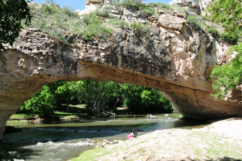
Before showing some pretty pictures, there was a particular feature of interest in the Park: the natural bridge over the Chipola River. When we hear “natural bridge”, we likely imagine something that might look like this:
The above photo is a Wiki shot of Ayres Natural Bridge in Wyoming. Really cool spot!
But hey, that’s Wyoming, and this is Florida. In case you’ve forgotten, Florida is flat. So, instead of the bridge raised above the river like the photo, in Florida, the “bridge” is at the same elevation as the surrounding land. The river dips down below the ground (in an underground channel). So when you come upon it, there really isn’t much to see.
Here’s a picture (once again, from the Explore Southern History website) of where the river appears to end. Of course, it’s really just briefly disappearing into the subsurface:
Here’s a little write-up from the same website:
In 1818, Andrew Jackson’s army crossed the Natural Bridge of the Chipola during the First Seminole War. Captain Hugh Young, a topographer assigned to the army, wrote:
The Natural Bridge is in the center of a large swamp and appears to be a deposit of earth on a raft or some similar obstruction. The passage is narrow and the creek, with a rapid current is visible both above and below.
Captain Young was wrong, of course, about the nature of the bridge. It actually is formed by the unique karst topography of the area. The river flows down into a sink, travels under the ground for a short distance and then rises back to the surface.
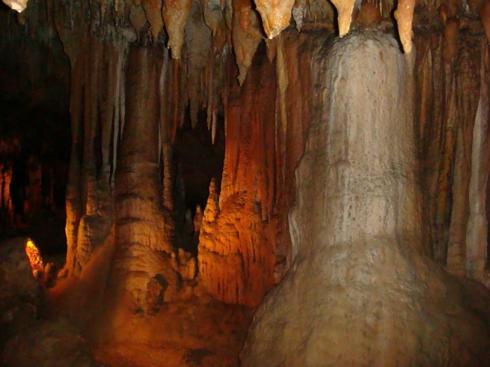
OK, time for some GE Panoramio pictures. I’ll start with some cave shots, with a couple by LJG Speer:
Here’s another by mihs 74:
Pretty cool cave, eh? Moving right along, here’s a Chipola River shot by Magry Diaz:
I’ll close with this photo taken by someone with the appropriate handle of Chipola. The picture is of (what else?) the Chipola River (at a very similar setting as the above photo):
That’ll do it.
KS
Greg
© 2014 A Landing A Day


