A Landing a Day

A geography blog where random is king . . .

Archive for September, 2014

Doland, South Dakota

Posted by graywacke on September 29, 2014

First timer?  In this formerly once-a-day blog (and now more-or-less a once or twice a week blog), I have my computer select a random latitude and longitude that puts me somewhere in the continental United States (the lower 48).  I call this “landing.”  I keep track of the watersheds I land in, as well as the town I land near.  I do some internet research to hopefully find something of interest about my landing location.  To find out more about A Landing A Day (like who “Dan” is and what the various numbers and abbreviations mean in the first paragraph), please see “About Landing,” (and “Abbreviations” and “Cryptic Numbers”) above.

 Landing number 2123; A Landing A Day blog post number 551.

Dan:  Back to the dark side (now 7 of the last 9), thanks to this OSer . . . SD; 58/53; 3/10; 9; 148.8.  Here’s my regional landing map:

 landing 1

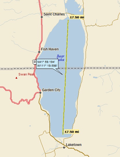
My local landing map shows my titular town (and the fact that I landed in the Timber Creek watershed):

 landing 2

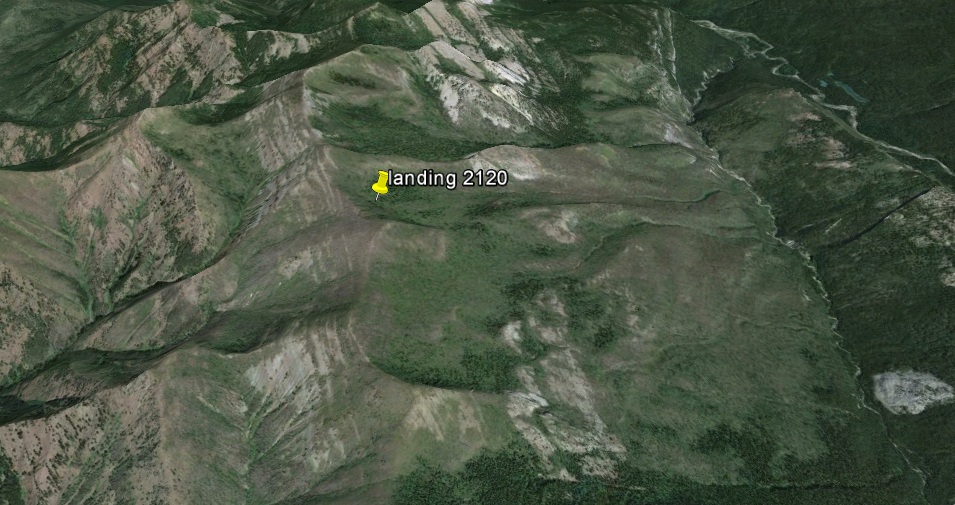
My Google Earth (GE) shot shows (of course), an agricultural setting:

 GE 1


Expanding a streams-only map, you can see that I landed in the James River watershed (19th hit); on to the Missouri (384th hit); on to the MM (832nd hit).

 landing 3a

Moving along to Doland (pop 180).  It has quite the famous son – Hubert Horatio Humphrey.  Consider this:

  • He served as a U.S. Senator from Minnesota from 1949 to 1965 and 1971 to 1978.
  • He was Vice President of the United States from 1965 to 1969 (under Lyndon Johnson).
  • He was the 1968 Democratic Party’s candidate for President, losing narrowly to Republican Richard Nixon.
  • His father ran a pharmacy in Doland from 1915 to 1929, and served as the town’s mayor for several years.

I remember him well, especially as candidate for President in 1968.

Boomer alert!  Mention 1968 and the memories start flowing.  In my life, it was that uniquely memorable year when high school is finished and college begins, but man – what a crazy year.  In today’s world (which is certainly crazy enough), it’s hard to convey just how crazy it was back then.  I’ll get to the 1968 election and Hubert Humphrey in a bit, but let me start with some bare facts about what went on in 1968:

  • The Vietnam War was in full bloom. The Tet offensive (the largest Communist campaign of the entire war) was launched in January.
  • One week after the Tet Offensive was launched, the North Koreans captured the USS Pueblo, a Naval intelligence ship and held 83 Americans as spies for 11 months. Interesting fact:  the North Koreans are still in possession of the ship. 
  • In March, US Troops massacred 347 civilians in Viet Nam (the My Lai massacre).
  • In April, Martin Luther King was assassinated.
  • Also in April, Columbia University students took over the Administration Building and closed down the University.
  • In June, Robert Kennedy was assassinated (and I graduated from High School).
  • In August, Czechoslovakia was invaded by Russia, crushing the “Prague Spring” liberalization movement, led by Alexander Dubcek.
  • Also in August, the Democractic Convention in Chicago (where Humphrey was nominated) was disrupted by massive protests.
  • In October, the famous black-fisted salute was performed on the medal podium at the Summer Olympics in Mexico City.
  • Three Apollo missions (6, 7 & 8) were launched during 1968, culminating in a manned lunar orbiting mission in December.

I was visiting a website that contained “Images of 1968.”  The images are very powerful, and for the most part disturbing, except for this memorable, uplifting photo from Apollo 8:

 GD*4927643

But then again, the spring of ’70 was even crazier.  Not to worry, I’ll probably have to land near Kent, Ohio to head off in that direction.  Anyway, getting back to Hubert Humphrey & the 1968 election.  I’ll start with a screen shot from Wiki:

 wiki candidate gallery

How about Eugene McCarthy?  From Wiki:

Running as an anti-war candidate in the New Hampshire primary, McCarthy hoped to pressure the Democrats into publicly opposing the Vietnam War. Since New Hampshire was the first presidential primary of 1968, McCarthy poured most of his limited resources into the state. He was boosted by thousands of young college students who shaved their beards and cut their hair to be “Clean for Gene”. These students organized get-out-the-vote drives, rang doorbells, distributed McCarthy buttons and leaflets, and worked hard in New Hampshire for McCarthy. On March 12, McCarthy won 42 percent of the primary vote to Johnson’s 49 percent, a shockingly strong showing against an incumbent president.

And then,

On March 31, 1968, following the New Hampshire primary and Kennedy’s entry into the election, the president announced to the nation in a televised speech that he was suspending all bombing of North Vietnam in favor of peace talks. Johnson concluded his speech and startled the nation by announcing “With America’s sons in the fields far away, with America’s future under challenge right here at home, with our hopes and the world’s hopes for peace in the balance every day, I do not believe that I should devote an hour or a day of my time to any personal partisan causes or to any duties other than the awesome duties of this office—the presidency of your country. Accordingly, I shall not seek, and I will not accept, the nomination of my party for another term as your President.”

Oh my.  Continuing . . .

After Johnson’s withdrawal, Vice-President Hubert Humphrey announced his candidacy. Kennedy was successful in four state primaries (Indiana, Nebraska, South Dakota, and California) and McCarthy won six (Wisconsin, Pennsylvania, Massachusetts, Oregon, New Jersey, and Illinois).  Humphrey did not actively campaign in these states.

The political landscape was different back then.  The delegates were not lock-step with the results of the primary voting like they are now.  Humphrey was biding his time, but he still put out this campaign poster:

humphrey campaign poster

Back to Wiki:

California was the next key contest.  Kennedy campaigned in the ghettos and barrios of the state’s larger cities, where he was mobbed by enthusiastic supporters. Kennedy and McCarthy engaged in a television debate a few days before the primary; it was generally considered a draw. On June 4, Kennedy narrowly defeated McCarthy in California, 46%–42%.

However, McCarthy refused to withdraw from the race and made it clear that he would contest Kennedy in the upcoming New York primary, where McCarthy had much support from anti-war activists in New York City.

The New York primary quickly became a moot point, however, for in the early morning of June 5, Kennedy was shot shortly after midnight; he died twenty-six hours later. Kennedy had just given his victory speech in a crowded ballroom of the Ambassador Hotel in Los Angeles.

Obviously, Robert Kennedy’s death drastically altered the dynamics of the race. Although Humphrey appeared the prohibitive favorite [in spite of his lack of primary victories] for the nomination, thanks to his support from the traditional power blocs of the party, he was an unpopular choice with many of the anti-war elements within the party, who identified him with Johnson’s controversial position on the Vietnam War.

However, Kennedy’s delegates failed to unite behind a single candidate who could have prevented Humphrey from getting the nomination. Some of Kennedy’s support went to McCarthy, but many of Kennedy’s delegates, remembering their bitter primary battles with McCarthy, refused to vote for him. Instead, these delegates rallied around the late-starting candidacy of Senator George McGovern of South Dakota, a Kennedy supporter in the spring primaries who had presidential ambitions himself. This division of the anti-war votes at the Democratic Convention made it easier for Humphrey to gather the delegates he needed to win the nomination.

Note:  You can really see that this was when the infamous cigar-smoke-filled-back-rooms made a difference in who was nominated.  Humphrey never had near as many popular votes as Kennedy or McCarthy.  Oh, well . . .

When the 1968 Democratic National Convention opened in Chicago, thousands of young activists from around the nation gathered in the city to protest the Vietnam War. On the evening of August 28, in a clash which was covered on live television, Americans were shocked to see Chicago police brutally beating anti-war protesters in the streets of Chicago in front of the Conrad Hilton Hotel. While the protesters chanted “The whole world’s watching,” the police used clubs and tear gas to beat back or arrest the protesters, leaving many of them bloody and dazed.

Oh man.  I remember the scene and the chant . . .

Anyway, Richard Nixon was the Republican candidate, and George Wallace joined the fray.  George was a serious candidate:

The American Independent Party nominated former Alabama Governor George Wallace – whose pro-segregation policies had been rejected by the mainstream of the Democratic Party – as the party’s candidate for president. The impact of the Wallace campaign was substantial, winning the electoral votes of several states in the Deep South. Wallace was the most popular 1968 presidential candidate among young men.  Wallace also proved to be popular among blue-collar workers in the North and Midwest, and he took many votes which might have gone to Humphrey.

Politics have changed a little, eh?

But at the end of the day, here’s the vote:

Nixon:        31,783,783

Humphrey:  31,271,839

Wallace:   9,901,118

The Electoral College tally:

Nixon:  301

Humphey:  191

Wallace:  46

I would call Nixon an OSer and both Humphrey & Wallace, USers . . .

By the way, I think that the Electoral College is an abomination!

One last word about Humphrey.  He returned to the Senate in 1970, where he remained until his death (of bladder cancer).  After his diagnosis with the terminal disease (while in the final weeks of his life), he called on Richard Nixon to personally invite him to his funeral. 

Enough already.  Back to my landing location!  Take a look at this GE shot.  You can see that I was lucky enough to land near a cluster of Panoramio photos (just three miles away):

 GE 2 - pano shots

Except for the more isolated photo to the southeast, we have pictures of the Mayer Farm (taken by an excellent photographer, Devan Mayer).  I’ll start with her shot of Timber Creek:

 pano devan mayer stream

What’s a farm without a big red barn?

 pano devan mayer barn

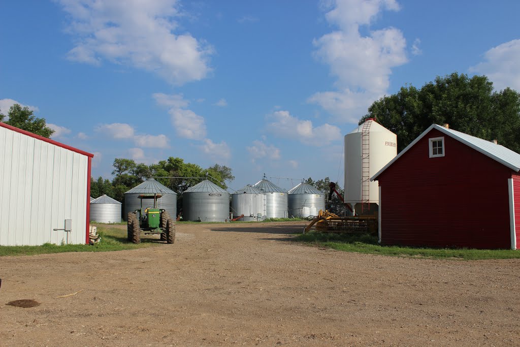
Here’s another of the business end of the farm:

 pano devan mayer farm

Devan wandered across the road (to the southeast, as mentioned earlier) to take this shot of an old abandoned house:

 pano devan mayer old house

It turns out that the same old house caught the eye of another photographer, Bennett2904:

 pano bennett2904

Notice how the angle of each photo is the same, and the sun is behind the house in both shots.  But what incredibly different photos!

I’ll come back to Devan with this sunset shot from the Mayer farm:

 pano devan mayer sunset

That’ll do it.

KS

Greg


© 2014 A Landing A Day


Posted in Uncategorized | Tagged: , , , , | Leave a Comment »

New Castle, Indiana

Posted by graywacke on September 22, 2014

First timer?  In this formerly once-a-day blog (and now more-or-less a once or twice a week blog), I have my computer select a random latitude and longitude that puts me somewhere in the continental United States (the lower 48).  I call this “landing.”  I keep track of the watersheds I land in, as well as the town I land near.  I do some internet research to hopefully find something of interest about my landing location.  To find out more about A Landing A Day (like who “Dan” is and what the various numbers and abbreviations mean in the first paragraph), please see “About Landing,” (and “Abbreviations” and “Cryptic Numbers”) above.

 Landing number 2122; A Landing A Day blog post number 550.

Dan:  After six for seven in the wrong direction (i.e., OSers), I broke out with this USer . . . IN; 22/25; 4/10; 8; 148.5.

Here’s my regional landing map:

 landing 1

My local landing map shows why I had no indecision about my titular town:

 landing 2

Here’s the first part of my watershed analysis:

 landing 3

I landed in the watershed of the Flatrock River (1st hit ever!); on to the East Fork of the White River (5th hit, making it the 155th river on my list of 5 or more hits).

Here’s the second part of my watershed analysis:

 landing 3a

From the E Fk of the White, on to the White (9th hit); to the Wabash (23rd hit); to the Ohio (131 hits); and finally, inevitably, to the Mighty Mississip (831 hits).

 Even though I landed close to New Castle, you wouldn’t know it from this close-in Google Earth shot:

 GE 1

Zooming back a little, here’s the entire town:

 GE 2

By the way, my new feature (the Google Earth trip from my last landing) is bothering me.  For some reason, my screen capture software makes the trip so jerky as to be annoying.  So, until further notice, these trips will be suspended . . .

Moving right along to New Castle.  It’s quite the substantial town, with a population approaching 20,000.  I’m having a little trouble finding a good hook, but three Wiki items caught my eye.  First, it turns out that New Castle is home to the “largest high school gymnasium in the world.”  Hey.  If Wiki says it’s so, it must be so.  Here’s a picture:

 fieldhouse

It seats just a little below 10,000 people.  Wow.  Half of the town population would fit!

Then, there’s a young baseball prospect from New Castle with a name that absolutely grabs your attention:  Trey Ball.

He’s only 20 years old, and is currently a pitcher for the Red Sox Class A Minor league franchise in Greenville NC.  If Trey makes “The Show,” we’ll all no doubt remember we first learned about him on A Landing A Day.  One can only imagine the fun that Major League announcers will have with his name. 

And then, I see where New Castle is the hometown of one Robert Indiana.  Now, I’ve never heard of Robert Indiana, but (speaking of catchy names) he certainly has a catchy name, eh?  So why does Wiki even mention him?  Well, his claim to fame is the iconic rendition of the word “LOVE.”  Here’s the 1975 postage stamp version:

 wiki love stamp

Anyway, Mr. Indiana (sounds like a body-building champion, eh?) was born “Robert Clark.”  In 1958 (at the age of 30), he changed his last name to Indiana paying homage to his home state (I guess).  Makes me think of John Denver.  He was born Henry John Deutschendorf, but changed his name to John Denver (after the capital of his favorite state) early in his career.

Of course, there are numerous “Love” statues around the world (the first one was placed in Indianapolis in 1970).  I’m familiar with this one in Philadelphia (put up as part of the Bicentennial celebration of 1976):

 Love park philly wiki

According to Wiki, there are 17 of the statues in the U.S., two in Canada, seven in Europe and 11 in Asia.  A couple aren’t in English.  Here’s an Italian “Amor” statue:

 italian amor

And this, digitally-enhanced version (color-added) of a Love statue in Israel (in Hebrew):

 israel hebrew

Moving right along –  I stumbled on one additional item of local interest.  Here’s a Panoramio shot by AlanCrab of a statue in front of the Ice House Tavern in New Castle:

 pano AlanCrab Giant Blue Man

It is what it is.  (Not my favorite expression.  I’ll try not to use it again.)

I’ll close with this Panaoramio shot of a barn (by Sebass 10) about 7 miles SE of my landing:

 pano sebass 10 (Thomas) barn 7 mi se

That’ll do it.

KS

Greg


© 2014 A Landing A Day


Posted in Uncategorized | Tagged: , , , , | Leave a Comment »

Hazen, Nevada

Posted by graywacke on September 17, 2014

First timer?  In this formerly once-a-day blog (and now more-or-less a once or twice a week blog), I have my computer select a random latitude and longitude that puts me somewhere in the continental United States (the lower 48).  I call this “landing.”  I keep track of the watersheds I land in, as well as the town I land near.  I do some internet research to hopefully find something of interest about my landing location.  To find out more about A Landing A Day (like who “Dan” is and what the various numbers and abbreviations mean in the first paragraph), please see “About Landing,” (and “Abbreviations” and “Cryptic Numbers”) above.

 Landing number 2121; A Landing A Day blog post number 549.

Dan:  I’m staying out west and staying with the OSers (in fact, 6 of my last 7 landings have been OSers), thanks to this landing in . . . NV; 83/77; 4/10; 7; 149.0.

Here’s my regional landing map:

 landing 1

And my local landing map:

 landing 2

Fasten your seatbelts and let’s go via Google Earth from Swan Lake MT (my last landing) to this one:


Here’s a ground-level GE shot looking general east past my landing.  Pretty cool, eh?

 GE 2

Zooming back a little, you can see I landed on a double-humped hill:

GE - island

This is one of the landings (like Drummond Island MI), where a quick elevation trace on Google Earth (GE) shows my drainage pathway.  It goes in a fairly straight line between my landing and a local low point about two miles away:

 GE - drainage

OK, so if it was a huge rain and the local low filled up, I suppose I could extend the drainage analysis, but I’m in the Nevada desert and we all know any rain ain’t goin’ nowhere.

So, I checked out Fernley.  Not much in the way of a hook.  But let me tell you, this is a thriving community.  Just like I did 12 posts ago for Lonerock and Hardman, Oregon, I’ll present a population trend analysis.  By the way – before I do Fernley, let me remind you that Lonerock and Hardman peaked at less than 200 folks back in 1920 and have been going downhill ever since.  But check out Fernley:

 Fernley pop

OK, so an Amazon.com distribution center just announced it was relocating from Fernley to nearby Reno (about 30 miles away), but obviously, Fernley has more going for it than just Amazon . . .

So, I looked at Wadsworth. Wiki tells me that Joe Conforte was the owner of the first legal brothel in the United States (the Mustang Ranch in 1967).  But the Mustang Ranch was not in Wadsworth.  Back in 1957 or so, he opened the Triangle River Ranch in Wadsworth, with some questionable (read illegal) activities going on.  In 1959, Conforte served 22 months in jail after attempting to blackmail Washoe County District Attorney Bill Raggio, who summarily had the ranch burned down.

Now wait a second.  This scoundrel . . . er – I mean entrepreneur . . . is arrested and convicted of blackmailing a DA (and operating an illegal brothel).  And then, a mere 8 years later, the State of Nevada decides that he’s the right guy to open the first legal brothel.  Yea, right . . .

OK, moving right along.  How about Hazen?  Well, I had to use Hazen as my titular town, because . . . 

It's happening in Hazen

So let’s see.  Well, Hazen is the site of the last lynching in Nevada (a gentlemen named Red Wood in 1905), but that’s no hook. 

OK, there’s a Hazen site on the National Register of Historic Places.  Here’s a Wiki picture of the Hazen Store:

 800px-HazenStore2 wiki

Part of it was built in 1904, then moved to its current location in 1944, when the rest of the structure was built.  According to Wiki, it’s on the Register “as an illustration of a commercial property on the Reno Highway.”  Yea but – so’s the Dunkin’ Donuts in Fernley . . .

So it turns out that there’s no hook at all.  But there are some cool back-in-the-day pictures.  First this old Lincoln Highway road sign (taken on Route 50 about halfway between Fernley & Hazen):

 hazen motorcities.org lincoln highway sign

And this 1911 shot of the Palace Hotel.  Quite the place . . .

 HAZEN-PALACE_HOTEL-1911-PH175-6

With a very nice lobby!

 HAZEN-PALACE_HOTEL-PH635-7

Here’s a shot of the Recreation Inn Café & Bar.  I wonder what sort of recreation goes on at the inn?

 hazen - old time

And this shot (most prevalent on the web) of “Saloons and Disreputable Places of Hazen, 1905”:

 hazen- Saloons_and_disreputable_places_of_Hazen_(Nev.)_June_24,_1905.-_By_Lubkin_-_NARA_-_

Moving right along.  Of course, I checked out Panoramio photos close to my landing.  The closest one is this, posted by Robert Stolting (of Fernley) with an intriguing title:  “Sculptor’s Work, High and Dry.”

 pano robert stolting .67 mi se tufa

The caption for the photo:  “Tufa formation, formed thousands of years ago from calcium carbonate precipitating out of a spring entering an ancient crash water lake.”

Right out of the gate, I had to see what a “crash water lake” is.  I mean, I’m a geologist and that’s an expression I’ve never run across.  After a quick Google search, it looks like no one else has ever run across it, either.  I think that Mr. Stolting intended to say “fresh water lake.”

Once that change is made, the caption makes perfect sense.  Tufa is a limestone rock formed when spring water, enriched with calcium carbonate (the stuff of limestone), discharges underwater into a fresh water lake.  The calcium carbonate precipitates out of solution, progressively forming tufa one microscopic layer at a time (all of this under water).  When the water levels retreat, out pops the tufa!  Tufa can result in some very interesting-looking formations. 

Here are two tufa shots (or is that tu twofa shots) at Pyramid Lake (located about 30 mi NW of my landing; just NW of Nixon on my local landing map above).  First this, from Photo River Blog (Hammon Photography):

 hammon photography photo river blog

And this, from Rachid Photo:

 rachid photo

Any question why it’s called Pyramid lake?  

So, we need a big ol’ lake near my landing.  As discussed in my Susanville CA post, the lake is Lake Lahontan, of which Pyramid Lake is a remnant.  Here’s a map of the lake (from Stanford U.):  

 stanford lake lanohan

You can see that my landing was right on the shoreline (more about that later).  Also – see the portion of the lake that crosses the border into California?  That’s near Susanville (mentioned above).

Here’s what Wiki has to say about the lake:

At its peak approximately 12,700 years ago (as the continental glaciers were in retreat), the lake had a surface area of over 8,500 square miles. The depth of the lake was about 900 feet at present day Pyramid Lake, and 500 feet at the Black Rock Desert. Lake.  At its peak, Lahontan, would have been one of the largest lakes in North America.

So let’s look a little closer at my landing location (thanks to a USGS map), and the location of the tufa deposit in Robert Stolting’s Pano photo:

 usgs lahonton map

Note that the lake elevation is 4370, and my landing elevation is 18′ above that.  So, I landed right on the shore of the lake, or even more likely, on an off-shore island (the double-humped hill shown on the GE shot near the beginning of the post).  The tufa (and its associated underwater spring) was less than a mile to the south of the island (in about 140’ of water, at the deepest).  

There you have it.

Moving right along (and keeping with Robert Stolting).  The second closest Pano shot to my landing is another of his photos, about 1.5 mi NE of my landing:

 pano robert stolting 2 mi NE

I’ll close with this shot by SlakingFool, about 12 mi SW of my landing:

 pano slakingfool, e of fernley looking towards hazen

That’ll do it.

KS

Greg


© 2014 A Landing A Day


Posted in Uncategorized | Tagged: , , , , , , | Leave a Comment »

Swan Lake, Montana

Posted by graywacke on September 12, 2014

First timer?  In this formerly once-a-day blog (and now more-or-less a once or twice a week blog), I have my computer select a random latitude and longitude that puts me somewhere in the continental United States (the lower 48).  I call this “landing.”  I keep track of the watersheds I land in, as well as the town I land near.  I do some internet research to hopefully find something of interest about my landing location.  To find out more about A Landing A Day (like who “Dan” is and what the various numbers and abbreviations mean in the first paragraph), please see “About Landing,” (and “Abbreviations” and “Cryptic Numbers”) above.

 Landing number 2120; A Landing A Day blog post number 548.

 Dan:  Gee whiz.  I can’t get out of the greater Northern Utah / Idaho / Western Montana region (four in a row!).  Here’s my second recent visit to OSer . . . MT; 121/102; 4/10; 6; 148.7. 

Here’s my regional landing map:

 landing 1

Here’s a regional map showing my last four landings:

 landing 1a

My local landing map shows my proximity to Swan Lake:

 landing 2

Zooming back a little, you can see how close today’s landing (2120) is to landing 2117:

 landing 2a

Here’s a map showing my more local watersheds:

 landing 3

You can see that I landed in the watershed of Silvertip Creek; on to the Spotted Bear River (1st hit!); on to the South Fork of the Flathead River (2nd hit – and the first hit was the nearby landing 2117!).  Moving back a little, we can see more of the watershed story:

 landing 3a

 From the South Fork of the Flathead River, on to the Flathead River (12th hit); to the Clark Fork (20th hit); to the Pend Oreille (22nd hit); to the Mighty Columbia (152nd hit).

OK, so you can’t see it on the map, but you’ll have to trust me that south of Flathead Lake, the Flathead flows into the Clark Fork . . .

It’s time for the Google Earth trip from Yellow Pine to Swan Lake:


Here’s a static oblique GE shot, looking north – what a cool spot!

 GE1

Moving back, we see a fascinating geological landscape (still looking north):

 GE2

Wow.  There’s some awesome geology going on here.  I wish I knew the story so I could relate it everyone.  It looks like the white beds are tilted, sloping upward to the west (that would be dipping east, to use correct terminology).  The rocks are totally different moving west, but it’s tough to figure out the structure.  Oh, well.

So, on to Swan Lake.  From SwanLakeMontana.org:

In the early 1900’s Swan Lake began as a community of loggers cutting timber for lumber and the ties to build the Great Northern Railroad. Some say that our name comes from the trumpeter swans that used to populate the lake.  Others say that it was named after Emmett Swan, an early resident. Others simply say the name comes from the mountains to our east. No matter how we got the name, Swan Lake is known today as home to those who enjoy everything this part of Montana has to offer.

I couldn’t really find a geographical, geological or historical hook.  The lake valley was dug out / dammed up by the glaciers (no surprise there).  So where to go with this post?  How about back to Pyotr Ilyich Tchaikovsky, or, more specifically, his best-known ballet piece, none other than Swan Lake.  Here’s ol’ Pyotr’s picture (from Wiki):
640px-Tchaikovsky_1906_Evans

True confessions:  I had no clue what this incredibly famous composer looked like!

Continuing my true confession, I had no clue what “Swan Lake” is all about.  So, I lifted a synopsis of the story line from the Houston Ballet website.  Right up front, let me apologize for the irreverent comments that I’ve inserted.  Hey – I’m just being honest (and left-brained).  Well, here goes:

 Act I

 Scene I: Deep in a Dark Wood

Odette, a young maiden, is in the forest.  The evil knight Rothbart appears and captures her, turning her into a white swan.

[“Ho Hum. I think I’ll turn this woman into a swan.  Why?  Because I can.”]

She is cursed to remain a swan during the day, and a maiden at night.

[Why not the other way around?  Why not a full-time swan?  Oh, well.]

Scene II: A Royal Hunt at the Edge of the Wilderness

Later, the young Prince Siegfried and his entourage arrive in the forest and set up camp, celebrating the day’s hunt.  The Queen calls her son aside and reminds him that tomorrow is an important day, as he is now a man and eligible for marriage.

She introduces him to four eligible young princesses, but he is distant and uninterested.

[Why would any healthy, red-blooded young man be disinterested??  Did he have a premonition that his one true love was soon to appear?]

The Queen sternly warns him that this is the last night of his youth and that he must soon take on the responsibility of adulthood.  Upset, Siegfried decides to leave the camp and venture out into the woods alone.

 Scene III: In the Forest

Deep in the forest that evening along the edge of a lake, Siegfried sees a young maiden.  Odette is beautiful, and he falls instantly in love.

[Oh, all right.  Love at first sight.  I get that.]

However, she is terrified, and begs him to leave, to no avail.  Charmed by his bravery, Odette finds herself falling in love with him.

As the sun begins to rise, the evil knight Rothbart summons Odette.  She goes to him and is transformed into a swan and flies away.  Soon thereafter, a large flock of swans lands on the lake.  Hunters from the royal party see the flock and prepare to shoot, but the Prince intervenes and orders them not to shoot.  Siegfried notices that one of the swans is Odette and he professes his love to her.

[Odette’s a swan.  How does Siegfried recognize her?  A distinctive birth mark?  Also – he professes his love to her!  Can Odette the swan understand Russian?]


Act II

The next night, the Queen hosts a ball and presents eligible princesses to her son, but the Prince pays little attention.  Suddenly, Rothbart and a maiden dressed in black arrive.

[Rothbart can crash the Queen’s party?  What about security?]

It is Odile.  She is the mirror image of Odette.

[The old “mirror image” trick.]

The Prince is smitten with the mysterious woman in black and begs his mother to consider the new arrival.

[Are you kidding me?  So quickly, he has forgotten about Odette?]

Siegfried and Odile dance and he proclaims his love for her; he tells his mother that he wants to marry Odile.

[I’m sorry, Sieggy’s a loser.]

Just then, Siegfried sees Odette in the crowd.  She is horrified by the betrayal and runs out.  The prince runs to Odile and realizes that she is one of Rothbart’s swans and that he has been fooled.

[Fooled?  Lousy excuse for abandoning your true love!]

The devastated prince chases Rothbart as he flees the court.


Act III

While it’s still dark, the Prince arrives at the edge of the lake in the forest and begs the distraught Odette for forgiveness.

The sun comes up and the maidens turn back into swans in the morning mist.

Before long, Rothbart and his black swans appear and he summons all of the swans, including Odette.  The Prince, desperate to be with his love, grabs his crossbow to kill Rothbart. The Prince shoots, but his arrow hits Odette (the swan) instead.

[I hate it when that happens.  Imagine if his aim were better – the ballet sure would have a different ending . . .]

Rothbart holds Odette in his arms but when she falls, she is a maiden.  The spell Rothbart cast on Odette is broken, and the Prince runs to her.  Odette, as a woman, dies in the Prince’s arms.

He picks up her body and walks into the lake, drowning himself.  Young maidens appear from the forest, forever changed.

Phew.  OK – so, maybe with beautiful music and beautiful dancing, I wouldn’t be so cynical.  Speaking of beautiful music and beautiful dancing, I’ll move right along to some of both.  This is Four Little Swans, performed by the Marlinsky Ballet and posted by ClassicClips10:


I’ll then move right along to this clip of a performance by the Great Chinese State Circus (posted by Alyaz).  Note that there have been nearly 26 million views:


Enough classical music & ballet!  Time for some Panoramio pictures.  Once again, I’ll stay as close to my landing as possible.  I’ll start with this shot of the Spotted Bear River, about 4 mi NW of my landing (by AngKillian):

 pano angkillian spotted bear 4 mi NW

I wonder if the river bed with potholes looks like a spotted bear from some vantage point?  

All the rest of the pictures are by MontanaBackPacker.  Here’s a shot taken two miles east of my landing, looking east towards Pentagon Mountain:

 pano montanbackpacker 2 mi E looking E

Here’s another shot, also about two miles east, looking SW towards Silvertip Mountain:

 pano montanabackpacker 2 mi E looking SW towards silvertip peak

I’ll close with this stunning shot (from the same area), looking north:

 pano montanabackpacker 2 mi E looking N


KS

Greg


© 2014 A Landing A Day


Posted in Uncategorized | Tagged: , , , | Leave a Comment »

Yellow Pine, Idaho (revisited)

Posted by graywacke on September 8, 2014

First timer?  In this formerly once-a-day blog (and now more-or-less a once or twice a week blog), I have my computer select a random latitude and longitude that puts me somewhere in the continental United States (the lower 48).  I call this “landing.”  I keep track of the watersheds I land in, as well as the town I land near.  I do some internet research to hopefully find something of interest about my landing location.  To find out more about A Landing A Day (like who “Dan” is and what the various numbers and abbreviations mean in the first paragraph), please see “About Landing,” (and “Abbreviations” and “Cryptic Numbers”) above.

 Landing number 2119; A Landing A Day blog post number 547.

Dan –  My last landing (Bear Lake Utah) just missed Idaho by a mile – landing in the OSer UT as opposed to the USer ID.  I didn’t miss a second time . . .ID; 50/58; 4/10; 148.3.  Here’s my regional landing map:

 landing 1

I’ve had three landings in a row are in the same neck of the woods: western Montana, then northeast Utah, and now central ID:

 landing 1a

My local landing map shows my proximity to Yellow Pine:

 landing 2

Yellow Pine!  AYKM*?  My very first blog post (landing 1583 in November 2008) was Yellow Pine!  And that landing was my third landing near Yellow Pine (the first being landing 492 in July of 2004 and the second, landing 1355 in February of 2008)!  And I had another blog post where I landed near Yellow Pine, but featured another town – Roseberry – instead (landing 1858 in February of 2010)!

       *Are You Kidding Me?

So, this is my fifth Yellow Pine landing, which may not sound extraordinary to you, but it certainly sounds extraordinary to me!  (OK, OK, I promise:  no more exclamation points this post!) 

 Here’s a map showing my five Yellow Pine landings:

 landing 4

Let’s head up to Yellow Pine from Bear Lake, courtesy Google Earth (GE):

Before I forget, here’s my watershed map:

landing 3

My landing drains to Johnson Creek, on to the East Fork of the South Fork of the Salmon River (1st hit!); on to the South Fork of the Salmon River (2nd hit); to the Salmon River (13th hit); to the Snake River (75th hit); to the Columbia River (151st hit).  

Here’s a static, oblique GE shot of my landing, looking north:

 GE 1

So anyway, Yellow Pine it is.  I’m not going to wander off, and hook up with some other town.  No sir, not this time.  Here’s the GE trip from my landing to the town:

First off, I want to stress just how isolated this town is.  Here’s a slightly expanded landing map – the roads coming in from the south and west are both dirt roads:

 landing 5 isolation

I did a quick route map on Google Maps from Yellow Pine to McCall (the closest town).  Here ‘tis:

 google maps yellow pine to mcCall

Fifty miles takes three hours & ten minutes!!  Wow.  So, according to Google Maps, you average less than 20 mph on that road.  I have a feeling that with a tough pick-up, the trip can be made quite a bit faster (and generally is).

So, let’s have a listen to local resident Darwin DeBois for some history, some insights on wildlife management and local color:

In fact, it was the very same harmonica fest that I featured on the very first post of A Landing A Day.  Now I could update that post with news of the 2014 Harmonica Fest, but I think that the following from my original post captures the essence of the town and the Fest  just fine:

 yellow pine


chipmunk


            This is a  picture of Harmonica Fest 2008.  Wow!  Look at the crowds!  They actually close down Main Street for three days!!

 old post fest crowds

From the same website, this about the Village of Yellow Pine:

The village of Yellow Pine is high in the Idaho mountains (alt. 4,765 ft), 150 miles north of Boise, surrounded by national forests… and is known as the “Gateway to the Central Idaho Wilderness Area.”  You’ll see dirt streets, a real live “little red schoolhouse” (fondly known as The University of Yellow Pine), a wooded RV park, rustic cabins, country store, hotel, gas pumps, three tavern/cafes, and the Community Hall and Fire Hall.

The Pioneer Cemetery (which contains many historic grave stones) is in the forest near the Yellow Pine campground, about 1/4 mile from town.

old post cemetery


I love that “Dead End Road” has equal billing to the cemetery.

 If there’s a fire in Yellow Pine, don’t worry, this fine fire truck will be zooming to the scene:

 old post firetruck

Back to me in the here and now . . .

What I failed to mention back in ’08 is that there is no admission charge!  All you gotta do is figure out how to get yourself to Yellow Pine in early August, find yourself a place to camp, and then you’re all set for the time of your life!

I found the following video of an act at the 2014 Music & Harmonica Fest – a piece by the Half Fast Hillbillies:

And then this act, from the 2010 fest, entitled “Cirque du Saloon by Ali and Dylan.”  I mean where else will you find a woman performing with a hoola hoop, accompanied by a guitar and harmonica version of Sweet Georgia Brown?

While checking out You Tube, I noticed the following video by SunFlyer65, which shows a take-off and landing at a private airstrip near Yellow PIne.  This is very cool, and I highly recommend that you stay with it for the entire 4 minutes:

They’re flying over the East Fork of the South Fork of the Salmon River, not far from where Johnson Creek comes in.  Anyway, here’s a GE shot of the airstrip:

airport


Time for some Panoramio shots close to my landing.  I’ll start out 7 miles south, with this shot along Johnson Creek by ElkBender257:

pano elkbender257 on Johnson ck 7 mi n


Here’s one by Ralph Maughan (a familiar name) about 5 miles east:

pano ralph maughan  5 miles east


I used three of Ralph’s pictures in my Jackson Hole (part 2) post and one in my Cherry Creek NV post.


I’ll close with this shot by Jason Abbott of Johnson Creek about 2 miles north:

pano jason abbott 2 mi n johnson creek


That’ll do it.

KS

Greg


© 2014 A Landing A Day


Posted in Uncategorized | Tagged: , , , , , | Leave a Comment »

Bear Lake, Utah (and Idaho)

Posted by graywacke on September 3, 2014

First timer?  In this formerly once-a-day blog (and now more-or-less a once or twice a week blog), I have my computer select a random latitude and longitude that puts me somewhere in the continental United States (the lower 48).  I call this “landing.”  I keep track of the watersheds I land in, as well as the town I land near.  I do some internet research to hopefully find something of interest about my landing location.  To find out more about A Landing A Day (like who “Dan” is and what the various numbers and abbreviations mean in the first paragraph), please see “About Landing,” (and “Abbreviations” and “Cryptic Numbers”) above.

 Landing number 2118; A Landing A Day blog post number 546.

Dan –  Give me a break.  Five OSers in a row, then three USers in a row, and now, four OSers in a row, thanks to this landing in . . . UT; 76/59; 3/10; 148.9.  Here’s my regional landing map, which looks like a toss-up between UT & ID:

 landing 1

But as you may have suspected by the post title, I actually landed in the middle of Bear Lake, in UT:

 landing 2

I landed almost exactly one lousy mile south of ID, which is, of course, a solid USer.  So, let’s look at UT & ID:  Although adjacent states,  UT is 76/59 (over-subscribed by 17) while ID is 49/58 (under-subscribed by 9).  Oh well, the Landing God works in mysterious ways . . .

It’s time to fly with me from Seeley Lake to Bear Lake:


Here’s a static, oblique GE shot looking north:

 GE 1

Here’s a GE Street View shot from the east shore of the lake looking out at my landing:

 GE SV landing from East shore

Below is a streams-only shot that more-or-less shows that a drop of Bear Lake water heads north out of the lake into a canal that feeds the Bear River (3rd hit); which flows into the Great Salt Lake (14th hit); from Great Salt Lake, my drop has little choice but to evaporate . . .

landing 3


For this post, I’ve decided to feature the Lake and only the Lake –  as a geologist sees it.  I shan’t be writing anything about people or towns.  So here goes:

As my regular readers know, I enjoy learning about lakes, and what excuse they have for existing at all.  After all, lakes don’t come into existence during the course of normal landscape development.  If you take a big patch of high ground and start eroding it with millions of years of rainfall, you don’t get a lake – you get a dissected landscape, with every surface sloping down towards a stream, which leads to another stream, etc.

Something else needs to happen, like a glacier needs to dump a bunch of dirt and rocks and block up a stream.  Or maybe it’s a landslide that blocks the stream.  Or, a glacier simply gouges out a hole. 

Or maybe, the earth is splitting apart thanks to deep-seated tectonic forces, and a huge block of the earth is sinking.  And maybe the big hole that results fills up with water.  And maybe the block of the earth is sinking at a faster rate than it’s filling up with sediment.  And maybe Bear Lake is the result of that very sinking block of earth.

So, the eastern shoreline of the lake is marked by a fault, with (obviously), the lake side of the fault going down.  The west side of the lake is more like a hinge, so the basin slopes down from west to east.  Here’s a screen shot of a page from a wonderful pamphlet put out by the Utah Geological Survey (no need to read the words unless you’d like to – more about the pamphlet later):

 cross section

The total movement along the fault has been about three miles!  There’s way less than three miles of elevation difference, because the mountain has been busily eroding at the same time (over millions of years) that the fault has been moving.

Not surprisingly, the deepest part of the lake is just off the eastern shore.  Here’s a bathymetric contour map from Utah State University:

 lake depth utah state u

These are 5-meter contours; the deepest part of the lake is about 60 meters (about 200 feet) deep.

I mentioned the Utah Geological Survey pamphlet above.  Here’s the cover:

 why is bear lake so blue utah.gov

So, I guess I have to let you know why the lake is so blue:

 why is bear lake so blue utah.gov 2

Also in the pamphlet is information about the relationship between the Bear River and the Lake.  Here’s a picture showing variations on a theme over the past 220,000+ years (the current situation is in the lower right):

 bear river hydrology from utah.gov

For those curious, detail-oriented folks, here’s some additional information about the comings and goings of Bear River:

 time line, open & closed; utah.gov

To check out the entirety of this pamphlet, click HERE.

Because the lake is important for both flood control and agricultural water supply, folks have messed with the natural system a little.  There are hydraulic controls for the incoming water from the Bear River (via Mud Lake, part of the wetlands system north of the lake) and for the outgoing water (via a canal that goes back to the river). 

Here’s a GE shot showing that the two structures are close together along the north shore of the lake:

 GE 2 lake out & in

GE Street View coverage is available on the road that crosses both structures.  Here’s a view of the outlet structure looking towards the lake:

 GE SV lake outlet 1

And away from the lake:

 GE SV lake outlet 2

Here’s a view of the inlet structure, with Bear Lake off to the right out of the picture:

 GE SV lake inlet

As usual, I’m going to close with some pretty pictures.  Here’s a lovely Wiki shot of the lake with its very blue water:

 wiki cool shot of bear lake

And a Panoramio shot of the east shore of the lake, looking south (by Layne Parmenter):

 pano layne parmenter e shore of lake looking south

I’ll close with a Pano sunset shot over the lake by Carl Hancock:

 pano carl hancock sunset over lake

That’ll do it.

KS

Greg


© 2014 A Landing A Day


Posted in Uncategorized | Tagged: , , , , | Leave a Comment »