A Landing a Day

A geography blog where random is king . . .

Archive for May, 2015

Terre Haute, Indiana

Posted by graywacke on May 28, 2015

First timer?  In this formerly once-a-day blog (and now pretty much a once-every-three-or-four days blog), I have my computer select a random latitude and longitude that puts me somewhere in the continental United States (the lower 48).  I call this “landing.”  I keep track of the watersheds I land in, as well as the town I land near.  I do some internet research to hopefully find something of interest about my landing location.  To find out more about A Landing A Day (like who “Dan” is and what the various numbers and abbreviations mean in the first paragraph), please see “About Landing,” (and “Abbreviations” and “Cryptic Numbers”) above.

Landing number 2185; A Landing A Day blog post number 613.

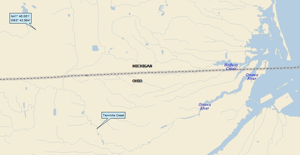
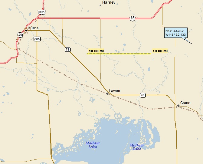
Dan:  Phew.  A USer . . . IN; 24/26; 3/10; 7; 151.0.  My regional landing map:

 landing 1

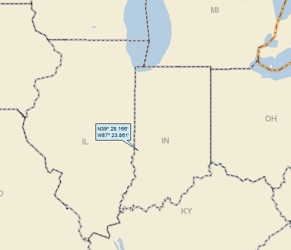
My local landing might give you a clue as to why Terre Haute made it as my titular town:

 landing 2a

To remove all doubt, I’ll zoom back a little:

 landing 2b

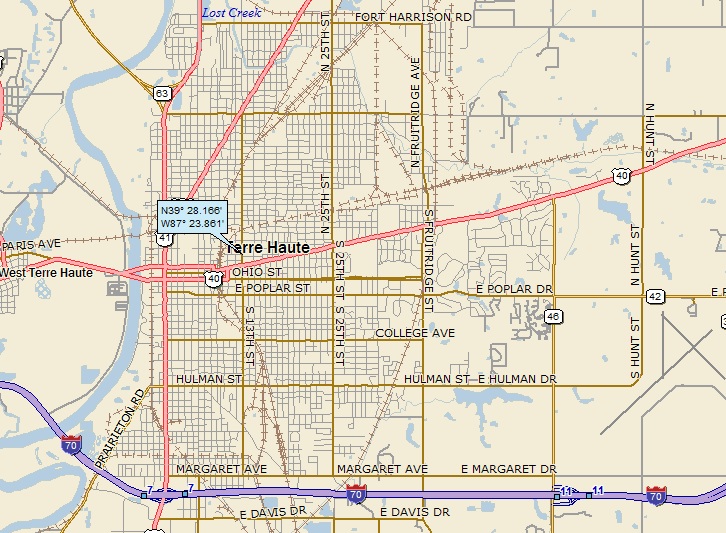
Before moving on to Google Earth (and yes, Street View is very exciting!), I’ll finish up my watershed analysis.  Terre Haute is a river town, and that’s the Wabash River on the above map (25th hit).  Here’s a streams-only map, showing that the Wabash at Terre Haute is not the state boundary line, but is just north of where that happens:

 landing 3a

Expanding the view by quite a lot, we see the following:

 landing 3b

The Wabash discharges into the Ohio (135th hit); on, of course, to the MM (855th hit).  Staying with the above map, notice how rivers and state lines coincide all over the place?

 Here’s the breakdown:

Wabash R
IN / IL

Mississippi R
MO / IL
MO / KY
AK / TN

Ohio R
KY / IN

KY / IL

Tennessee R
KY / TN

St. Francis R
AK / MO

There are four triple points on the map:

IN / KY / IL      (river river river)
KY / MO / IL     (river river river)
MO / TN / KY   (river river straight line)
AK / MO / TN   (river river straight line)

Triple point trivia:  There are 56 triple points (not counting international boundaries) among the lower 48.  Missouri and Tennessee are tied with the most triple points, at 8 apiece.  Kentucky is in second place with 7.  Last, with zero, is Maine.  (I didn’t look this up.  I did all of the leg work myself!)

Moving right along to my GE trip:


My next order of business is to get a GE close-up:

 ge 1

If you think that I should have an excellent Street View shot of my landing, you’re right.  Looking north on N 13th Street, here ‘tis:

 ge sv landing

Looking south on N 13th Street, here ‘tis:

 ge sv landing 2

I tried to find something about “Hair Machine,” but couldn’t really find anything.  They don’t have a website, and I couldn’t find any reviews.  Oh, well.

When I land near (or in, as in the case) a large town or city, it’s often a little tough to decided what to write about.  But I realized how close I was to Indiana State University, as you see below:

 ge 2 ISU

This isn’t the more famous Indiana University in Bloomington; I suspect that ISU plays second fiddle to IU (as Ohio University does to Ohio State University).

But as I familiarized myself with the campus, I grew to like it.  Although it’s right in the middle of Terre Haute, it has some beautiful open green spaces that I captured with GE Street View.  Here’s one:

 ge sv ISU 1

And in a different part of the campus, here’s another:

 ge sv ISU 2

While perusing the campus with GE, I saw this peculiar location (highlighted in yellow), not far from my landing:

 ge 3 trike course 1

Here’s a closer-in view.  It’s still peculiar and mysterious looking:

 ge 3 trike course 2

I went to a campus map and discovered that the building is called the Michael Simmons Student Activity Center, and the area with the track is known as “Recreation East.”  From the college website, here’s a picture:

 TrikeStartingLine2011

What in the heck is going on?!?  Is that someone on a tricycle?  Yes it is, and Cindy May (historian) wrote a piece on the university website about the annual Sycamore Tricycle Derby (aka the Trike Derby).  I’ve done some editing for briefness’ sake, but here’s some of the story:

On October 11, 1963 at 3:15 p.m. the students, faculty and staff of Indiana State College witnessed an event destined to become one of the university’s most enduring traditions—The Sycamore Tricycle Derby. “The spectator interest in the Derby was very high,” reported the Indiana Statesman. “[People] were lined up four and five deep all around the track, hanging out of classroom windows, and standing on top of buildings so that they could get a good view of the race.”

The race was run on the sidewalk around the main Quad for four years using children’s tricycles. Teams consisted of both men’s and women’s organizations, derived from sororities, fraternities, and residence hall students. During the four years on the small tricycles, students began to take the race seriously. They sought a more competitive challenge and wanted a faster paced race. Although no one knew it at the time, the “Trike Race” would become an integral part of Indiana State University’s homecoming tradition.

[Through the years, the venue changed and the tricycles were larger and more serious racing machines.  The popularity of the event only grew through the years.  Eventually, in 2000, the race moved to its current location.]

In 2004 the Trike Committee in collaboration with Indiana State University’s Facilities Management Staff painted permanent pit and racing lines on the track at Recreation East.

The Michael Simmons Student Activities Center stands in testament to the endurance of a homecoming tradition. Dedicated on October 21, 2005, the building contains the Susan Bareford Memorial Classroom, storage for the trikes, restrooms, bleachers for onlookers, and a covered observation deck.

The impact of the Sycamore Tricycle Derby on its proponents is indelible. Riders across the decades speak passionately of the experience. Dedication, hard work, persistence, courage, cooperation, camaraderie, bonds that last a lifetime, all describe the meaning of trike to its participants

From its “kick-in-the-butt” origins in 1963 to its sophisticated organization in the twenty-first century, the Sycamore Tricycle Derby endures as a homecoming tradition at Indiana State University.

How about that?  ISU actually built the facility for the once-a-year tricycle race!  Check this out – it’s pretty intense:


Among people who no doubt enjoyed the Trike Derby is Indiana State University alumnus Larry Bird.  From Wiki:

Bird received a scholarship to play college basketball for the Indiana Hoosiers in 1974.  After less than a month on campus, he dropped out of school, finding the adjustment between his small hometown and the large student population of Bloomington to be overwhelming.

[Take that, Indiana Hoosiers!]

He returned to French Lick, enrolling in a community college and working municipal jobs for a year before enrolling at Indiana State University in 1975.

[And he went to ISU!  In your face, Indiana!]

He had a hugely successful three-year career with the Sycamores, helping them reach the NCAA tournament for the first time in school history and leading them to the championship game against Michigan State in 1979.

[Indiana wasn’t even in the tournament that year!]

Indiana State would lose the game 75–64.  The game achieved the highest ever rating for a college basketball game in large part because of the match-up between Bird and Spartans’ point guard Earvin “Magic” Johnson,  a rivalry that lasted throughout their professional careers.

Despite failing to win the championship, Bird earned a slew of year-end awards and honors for his outstanding play including the Naismith College Player of the Year Award.

For his college career, he averaged 30.3 points, 13.3 rebounds, and 4.6 assists per game, leading the Sycamores to an 81–13 record during his tenure.

Just a side note.  I’m a Philly guy, and I remember that during the 1979 tournament, the University of Pennsylvania (Penn, not Penn State) did incredibly well, considering their lowly basketball status as an Ivy League team.  They beat Iona (sorry, Iona, but no big deal).  But they then went on to beat North Carolina (#1 seed), Syracuse and St. John’s, making it to the Final Four.  Then they got blown away by Magic Johnson and Michigan State.  Still – a great run!

I’ll leave Larry Bird now, and not continue with his great Boston Celtics pro career.  But I’ll close this segment with a November 1977 Sports Illustrated cover featuring Bird (his Junior year):

 Larry Bird 3

The infamous SI jinx did not hold true for Larry . . .

Before leaving basketball altogether, let me mention that the legendary UCLA basketball coach John Wooden spent two years as coach at ISU (1946 – 1948).  He went on to UCLA from ISU.

While perusing GE Panoramio shots, I found this, by Robert Maihofer II:

 pano robert maihofer II debs house

This is the home of Eugene V. Debs, famous Union Leader and Socialist (5-times Socialist Party candidate for President of the U.S.), and it’s right on the campus.  From Wiki:

The Eugene V. Debs House, on the campus of Indiana State University in Terre Haute, Indiana, was a home of the famous union leader. It was declared a National Historic Landmark in 1966.

Debs and his wife, Kate, built the two-story frame house in 1890, after their fifth wedding anniversary. Debs was criticized for the house not portraying working-class lifestyle; his wife was a beneficiary of her wealthy aunt’s will and could furnish the house affluently.

After Debs’ death, the house would see different owners. One was a professor at Indiana State University. It was used as the Theta Chi fraternity house from 1948–1961, and briefly was let as apartments. In 1962 the home was bought by the Eugene V. Debs Foundation, which continues to own the house.

Amazing that the house survived its tenure as a frat house . . .

Debs was quite the character.  An outspoken socialist his entire life, he spent some years in prison.  From Wiki:

Debs’ speeches against the Wilson administration and the war (WW I) earned the enmity of President Woodrow Wilson, who later called Debs a “traitor to his country.”  On June 16, 1918, Debs made a speech in Canton, Ohio, urging resistance to the military draft of World War I. He was arrested on June 30 and charged with ten counts of sedition.  He went to jail in April 1919.

While Debs was in prison, Wilson wrote:

“While the flower of American youth was pouring out its blood to vindicate the cause of civilization, this man, Debs, stood behind the lines sniping, attacking, and denouncing them….This man was a traitor to his country and he will never be pardoned during my administration.”

In January 1921, Attorney General Mitchell Palmer, citing Debs’ deteriorating health, proposed to Wilson that Debs receive a presidential pardon freeing him on February 12, Lincoln’s birthday. Wilson returned the paperwork after writing “Denied” across it.

On December 23, 1921, President Harding commuted Debs’ sentence to time served, effective Christmas Day. He did not issue a pardon. A White House statement summarized the administration’s view of Debs’ case:

“There is no question of his guilt….He was by no means as rabid and outspoken in his expressions as many others, and but for his prominence and the resulting far-reaching effect of his words, very probably might not have received the sentence he did. He is an old man, not strong physically. He is a man of much personal charm and impressive personality, which qualifications make him a dangerous man calculated to mislead the unthinking and affording excuse for those with criminal intent.”

When Debs was released from the Atlanta Penitentiary, the other prisoners sent him off with “a roar of cheers” and a crowd of 50,000 greeted his return to Terre Haute to the accompaniment of band music.  En route home, Debs was warmly received at the White House by Harding, who greeted him by saying: “Well, I’ve heard so damned much about you, Mr. Debs, that I am now glad to meet you personally.”

I’ll close with this GE Panoramio shot of a sunset over the Wabash River, shot from Fairbanks Park (by Michael Gerringer):

 pano michael gerringer sunset

That’ll do it.

KS

Greg


© 2015 A Landing A Day


Posted in Uncategorized | Tagged: , , , , , , , | 1 Comment »

Beowawe, Nevada (revisited)

Posted by graywacke on May 25, 2015

First timer?  In this formerly once-a-day blog (and now pretty much a once-every-three-or-four days blog), I have my computer select a random latitude and longitude that puts me somewhere in the continental United States (the lower 48).  I call this “landing.”  I keep track of the watersheds I land in, as well as the town I land near.  I do some internet research to hopefully find something of interest about my landing location.  To find out more about A Landing A Day (like who “Dan” is and what the various numbers and abbreviations mean in the first paragraph), please see “About Landing,” (and “Abbreviations” and “Cryptic Numbers”) above.

Landing number 2184; A Landing A Day blog post number 612.

Dan:  Yo Landing God!  Give me a break!  Six OSers in a row and my highest Score since November 2013, thanks to this landing in NV; 90/79; 3/10; 6; 151.5.  Plus, enough of Nevada, already.  Check this out:

Between landing 2121 and landing 2184 (64 landings), I’ve landed in NV 8 times!  8 is 12.5% of 64.  Nevada’s area is 110,567 sq mi; that of the lower 48 is 3,061,363 sq. mi.  Nevada’s area is 3.6% of that of the lower 48.  So I’ve landed in Nevada at about 4 times the rate that I should have over the last 64 landings.  That’s what Over-Subscribed (OS) is all about . . .

Anyway, enough bellyaching.  Here’s my regional landing map:

 landing 1

My local landing shows that I’m out in the middle of nowhere (I’ve been using that phrase a lot lately):

 landing 2

I’ll jump right to my Google Earth (GE) spaceflight aboard the yellow push pin:


I’ll stick with GE, showing you this shot of my local drainage pathway (the blue line).  Obviously, I landed in the Humboldt River watershed (26th hit):

 ge drainage

Showing that the Humboldt River is to Nevada what the Snake is to Idaho, here’s a map of the Humboldt River system:

 landing 3

As any regular reader might guess, I went looking on GE for StreetView coverage of a bridge over the Humboldt.  The closest spot with such coverage was in (not surprisingly) Beowawe:

 ge sv map bridge

Here’s the Street View shot of the river:

ge sv bridge

As you can see below, it was a gray day (maybe raining), unusual for Beowawe, I’m sure.  The road was wet, and the Google Cam driver must have been going at a good speed, because he was kicking up so much spray behind him that the rear-looking shot is obscured:

 ge sv bridge 2

I continued my Street View tour, jumping right into downtown Beowawe:

 ge sv map beowawe

Here’s the Street View:

 ge sv beowawe

Wait a minute!  It’s a rainy winter’s day when we’re on the bridge.  We’re a mile up the same road, and it’s a beautiful, sunny day.  What’s going on? 

The following clip is a Street View trip from the railroad tracks in Beowawe (seen above), north towards the bridge over the river.  You’ll see what happens:


Moving right along . . . I clearly remembered that I wrote a Beowawe post some time back, although I was surprised to learn that it was posted in March of 2009.  I quoted Wiki in that post, as follows:

Beowawe (pronounced bay-o-WAH-wee) is an unincorporated area and ghost town in Eureka County, in northeastern Nevada in the western United States.  Beowawe is a Paiute Native American word meaning “gate”.

Times have changed.  Right out of the gate, here’s what Wiki says now:

Beowawe (bay-ə-wah-wee) is a small town, misnomered on the internet as a ghost town.

Wait a second.  Microsoft Word puts a squiggly red line under Beowawe (signifying that it’s not in Word’s dictionary), but it also puts a squiggly red line under “misnomered.”  Every on-line dictionary I looked at confirms this, showing only the noun “misnomer.” 

So let me try:  Beowawe is a small town, mistakenly identified as a ghost town on the internet.  Better?

The updated Wiki entry also definitively says that Beowawe mean “gate” in Paiute.  However, the next Google entry after Wiki has the salacious title:  “Nevada town’s name may have salacious origins.”  Looks like a  must-read. 

It’s a Feburary 17, 2014 article on the Reno Gazette-Journal website by Marilyn Newton.  Here’s what she has to say about the name:

Beowawe.

The meaning of the name of the tiny Nevada town, south of I-30 between Battle Mountain and Elko, is in itself a mystery.

“Beowawe” apparently is a Native American and both the Paiute and Shoshone have some very interesting translations for it.

It seems that back in the mid-1800s a truly huge man of immense girth, one J.A. Fillmore, weighing more than 300 pounds, came to the area looking for possible town sites along the Central Pacific Railroad.

Legend says he had to relieve himself and when nearby Paiute women saw him they were so terrorized by his size, they ran screaming Bea-wa-we which was translated then very loosely as “big butt.”

Paiutes also state that part of their word “bewa” translates to “big balls.”

Local Shoshone confirm that Beowawe means one who has a large posterior. They also have a word, beacog, that means wide-spread legs, like when wiping a baby’s rear end. And their word, bewa, loosely means “the runs” or a place to take “a dump.”

Other historians say the area got its name from the conformation of hill that appears as an open gate. They say the Paiute word for gate is Beowawe. The Paiutes, however, disagree (and they should know, don’t you think?). And yet another said it is a Shoshone word meaning “big wagon.”

Whatever the meaning of Beowawe, it was always a tiny community and today only the few residents who call the place home keep it from becoming a ghost town. A number of old ruins remain.

Well, there you have it.  And note that she says it has a few residents that keep it from being a ghost town.

As I discussed in my 2009 post, there used to be a geyser field outside of Beowawe that was destroyed by power companies exploiting the geyser field for geothermal electric power.  Here’s a video (posted by turdbird20) that shows some footage of the old geyser field and bitterly laments the fact that the geyser field was destroyed:


As mentioned above, the video was posted by turdbird.  I wonder if that’s the meaning of another Indian word for Beowawe.

There’s a website with lots o’ pictures of Beowawe today and yesterday – the Elko County Rose Garden (a community garden website that morphed into a more general community website).  Click here to peruse their pictures.

I’ll close with one of their shots:

 020217beo_dee8

That’ll do it.

KS

Greg


© 2015 A Landing A Day


Posted in Uncategorized | Tagged: , , | Leave a Comment »

Ottawa Lake, Temperance and Erie, Michigan

Posted by graywacke on May 22, 2015

First timer?  In this formerly once-a-day blog (and now pretty much a once-every-three-or-four days blog), I have my computer select a random latitude and longitude that puts me somewhere in the continental United States (the lower 48).  I call this “landing.”  I keep track of the watersheds I land in, as well as the town I land near.  I do some internet research to hopefully find something of interest about my landing location.  To find out more about A Landing A Day (like who “Dan” is and what the various numbers and abbreviations mean in the first paragraph), please see “About Landing,” (and “Abbreviations” and “Cryptic Numbers”) above.

Landing number 2183; A Landing A Day blog post number 611.

Dan:  It’s getting ugly.  Here’s my fifth OSer in a row . . . MI; 54/42; 3/10; 5; 151.1.  Here’s my regional landing map:

 landing 1

By the way, I missed OH by less than three miles (more about that later).  My local landing map follows:

 landing 2a

Although I landed in Michigan, the big geographical hub isn’t in Michigan, it’s in neighboring Ohio:

 landing 2b

Although this post won’t touch on Toledo, it was painful for me to miss Ohio.  I mean, really.  Take a look at this Google Earth (GE) map, which shows landings since January 2013:

 ge 4

Look at all of those Michigan, Illinois and Indiana landings, and not one Ohio landing!  In fact, my last Ohio landing was in 2009!  And strangely, check out this list of my Ohio landings since I started my blog in November of 2008:

Landing 1706, Apr 2009  (Oxford)
Landing 1775, Aug 2009   (Geneva-on-the-Lake)
Landing 1806, Oct 2009   (Waverly)
Landing 1809, Nov 2009  (Swanton)

So, after two practically back-to-back Ohio landings (#ers 1806 & 1809), the Landing God decided to put an end to Ohio visitation.  Of course, Ohio is a USer . . .

Before I leave Ohio, check out this StreetAtlas map shot:

landing 2c


Look at the streets along the state line.  It certainly looks like Ohio welcomes development more than Michigan . . .

Anyway, let me take care of my watershed analysis:

 landing 3a

As you can see, I landed in the watershed of the Ottawa Lake Outlet; on to the North Tenmile Creek; and then slithering down into Ohio, to the Tenmile Creek.

Don’t ask me why I used “slithering.”  Anyway, here’s the rest of the story:

 landing 3b

Tenmile Creek makes its way to the Ottawa River (first hit ever!), which just makes it back into Michigan before discharging into Lake Erie (10th hit).  Of course, Lake Erie is in the St. Lawrence R watershed (99th hit).

Just for the record, this was my second “Tenmile Creek.”  My first was in West Virginia.

Time for my Google Earth (GE) trip in:


Notice that I landed on a golf course?  Here’s a static GE shot:

 ge 1

As seen on this Street View shot, I landed on the grounds of the Whiteford Valley Golf Club:

 ge sv golf

By the way, there’s a “foot golf” course at Whiteford as well.  I for one had never heard of foot golf.  Here’s the Whiteford Valley website has to say:

At one time or another, every golfer has been frustrated by the task of guiding his ball into one of those tiny 4.25-inch holes on the putting green.  The new 21-inch holes installed on Whiteford Valley’s East Golf Course this season sound like they’d be easier to aim for – but there’s a catch. You have to put away your golf clubs and use your feet.

Welcome to FootGolf, a hybrid of golf and soccer that’s been sweeping the world of golf in recent years. The idea of blending golf and soccer has been around for decades, but it wasn’t until the 1980s that Dutch enthusiasts created official rules and courses for the sport. It is now a recognized tournament sport in over 20 countries, and the American FootGolf League recognizes 85 participating U.S. courses in 29 states.

FootGolf is played with a regulation #5 soccer ball, and its basic rules are like those of golf: the first shot at each hole has to be taken from the tee, and players must play past the usual array of bunkers, trees, water hazards and hills.

Here’s a Wiki picture of a foot golf match by Las Vegas Footgolf:

 Las_Vegas_FootGolf

For the record, this is my second golf course landing.  The first was landing 1793 (Sep 2009) in Ambler PA.  Here’s my GE shot from that post:

 ambler golf course 1

Here’s what I said then:  It turns out that I was on the edge of the 10th fairway.  The tee is up near the club house; the 10th green is down by the road.  Here’s a picture from the tee; I’ve put a black dot on my landing spot.  This is amazing!   My first ALAD photo showing where I actually landed!

ambler golf course2

Since then, with the expansion of Street View coverage, I have often posted pictures of precise landing spots, like this memorable Gladstone Oregon landing shot, where I landed on the edge of a dive shop parking lot:

 glad-ge2

Moving right along . . . I could find nothing about the town of Ottowa Lake; so I figured I’d check out the lake itself.  Yea, right.  It turns out that the lake itself is not obvious.  My best guess is this:

 ge 2

Here’s a closer view, showing that this isn’t much of a lake; much less a lake that would get a town named after it!

 ge 3

I spent an inordinate amount of internet time trying to find out something about the town’s name or the lake itself.  Nothing.  Rien.  Nada.

Maybe you can tell by the amount of non-hook material I’ve been presenting, that this is pretty much a hookless area.  OK, so one of the towns’ name is Temperance.  Here’s what Wiki has to say:

Temperance was established as Bedford Center in 1859. In 1884, a post office was established at Bedford Center and was named Temperance. The name was suggested by Martha Ansted, the wife of one of the founding land owners.  Martha Ansted was a member of the Woman’s Christian Temperance Union.

The Ansteds wrote restrictions into the deeds for all of the property they owned, specifying that alcohol could never be sold there. Other early settlers followed their lead. The restrictions lasted about 100 years, then were repealed on the initiative of a local businesswoman.

OK, enough Temperance.  How about Erie?  This from Wiki:

Erie was started in 1790 by Métis moving south from Monroe. Early on, a log church named St. Joseph sur la Baie Miami was built here. Father Gabriel Richard often would conduct Mass here. When a post office was established here in 1827, it was given the name of Bay Settlement.

First, a minor point:  “St. Joseph sur la Baie Miami” translates to St. Joseph on the Miami Bay.  The Maumee River (not Miami, but close enough) is the main waterway through Toledo (a much bigger river south of the little Ottawa River), and I assume that “Maumee Bay” more-or-less refers to the far western corner of Lake Erie.

But of potentially greater interest:  Erie was started by Métis moving south from Monroe?  It turns out that Monroe is town just 10 miles north of Erie.  So who or what are Métis?  From the Métis Nation of Ontario website:

The Métis are a distinct Aboriginal people with a unique history, culture, language and territory that includes the waterways of Ontario, surrounds the Great Lakes and spans what was known as the historic Northwest.

The Métis Nation is comprised of descendants of people born of relations between Indian women and European men. The initial offspring of these unions were of mixed ancestry. The genesis of a new Aboriginal people called the Métis resulted from the subsequent intermarriage of these mixed ancestry individuals.

Distinct Métis settlements emerged as an outgrowth of the fur trade, along freighting waterways and watersheds. In Ontario, these settlements were part of larger regional communities, interconnected by the highly mobile lifestyle of the Métis, the fur trade network, seasonal rounds, extensive kinship connections and a shared collective history and identity.

Wiki added this footnote:

Other former names—many of which are now considered to be offensive—include Bois-Brûlés, Mixed-bloods, Half-breeds, Bungi, Black Scots and Jackatars.

Who’d a thunk? 

The Métis flag is very simple (and it’s infinity, not 8):

6a4c186b-49e9-4214-8e7e-ec730fbbcd21

I searched far and wide for a suitable closing GE Panoramio shot.  Consistent with the hookless nature of this post, I couldn’t find one.  Not even a cool old barn.  So, here’s a shot on Route 23 North, heading into Michigan by j_racine30:

38265091

 That’ll do it.

KS

Greg


© 2015 A Landing A Day


Posted in Uncategorized | Tagged: , , , , , , , , , , | Leave a Comment »

Chambers, Sanders and Houck, Arizona

Posted by graywacke on May 19, 2015

First timer?  In this formerly once-a-day blog (and now pretty much a once-every-three-or-four days blog), I have my computer select a random latitude and longitude that puts me somewhere in the continental United States (the lower 48).  I call this “landing.”  I keep track of the watersheds I land in, as well as the town I land near.  I do some internet research to hopefully find something of interest about my landing location.  To find out more about A Landing A Day (like who “Dan” is and what the various numbers and abbreviations mean in the first paragraph), please see “About Landing,” (and “Abbreviations” and “Cryptic Numbers”) above.

Landing number 2182; A Landing A Day blog post number 610.

Dan:  Geez.  Four OSers in a row (and getting further over 150) thanks to this landing in . . . AZ; 87/81; 3/10; 4; 150.7. 

Here’s my regional landing map:

 landing 1

And my local landing map:

 landing 2

If it were to rain hard enough on my landing spot to generate runoff, and generate enough runoff to travel six miles, it would make its way to the Puerco River (2nd hit), which runs along I-40 on the above map:

 landing 3a

The StreetAtlas graphics are lousy (you can see the lines that I had to fill in), but the Puerco makes its way to the Little Colorado (19th hit); on to the Colorado (170th hit):

 landing 3b

Here’s my Google Earth (GE) trip in:


See the nearby north-side road?  That’s U.S. Route 191.  And yes (of course), it has Street View Coverage:

 ge map sv landing

And here’s what the orange dude sees:

 ge sv landing

Pretty cool about the bushes, eh?

Staying with GE StreetView, here’s a shot of the Puerco from a bridge in Sanders:

 ge sv puerco sanders

Wow.  It must have just rained!!!

I fear this is going to be one of those lack-luster, little-of-this, little-of-that, kind of posts.  Moving west to east with my little towns, I’ll start with Chambers.  Here’s what Wiki has to say:

Chambers was founded by Charles Chambers sometime before the railroad arrived in 1881. The name was changed to Halloysite for a period in honor of clay that was mined nearby, but changed back to Chambers on June 1, 1930.

So a town was named in honor of clay.  Well, what about halloysite?  First off, it’s a “clay mineral.”  I actually took a whole course in clay minerology when I was a grad student in geology at Kent State.  I pretty much hated the course and didn’t learn anything (but I somehow got an “A.”)  Anyway, we all know that clay is very very fine-grained sediment, right?  It turns out that different types of clay are actually distinct minerals (like quartz is a mineral), which means that it has a distinct chemical formula. 

A lot of clay comes from weathering of feldspar, which is an extremely common mineral in rocks like granite.  This explains why there’s so much clay (and the rock variety of clay, shale) everywhere on earth.

So, halloysite is a particular clay mineral composed of aluminum and silica and oxygen (and a smidge of hydrogen).  Wiki let me know that it was named after a Belgian geologist, Omalius d’Halloy.  Wiki also let me know that it commonly occurs with dickite.  Just sayin . . .

Wiki also let me know that halloysite naturally occurs as small cylinders, and I mean small:  30 nm in diameter; and 1 -5 micrometers in length.  FYI, “nm” is nanometers.  One nanometer is a billionth of a meter.  For reference, the diameter of human hair ranges from 17 to 180 micrometers (which equals 17,000 to 180,000 nanometers).  So right off, you can see that the length of a halloysite nano-tube is way, way less than the thickness of a human hair.

So where am I going with this?  (No where fast so far).  Well, I found this from MidasLetter.com, about the future of halloysite nanotube technology (starting with a photomicrograph of halloysite):

nanotubes

A study by Charles River Associates states that in 2010, the global market for halloysite was US$30 million.

That number is expected to rise dramatically as new applications are developed that could substantially increase the demand for halloysite in the not-so-distant future.

Halloysite – a kaolin clay whose structure is that of a rolled up tube – is rapidly emerging as a raw material of the future. Currently, it commands prices ranging from $600 per ton for applications in fracking, to $3,000 per ton for specialized medical and cosmetic applications.

Future widespread adoption of halloysite nanotubes is developing in:

Pharmaceutical Delivery:   Pharmaceutical ingredients loaded into halloysite nanotubes have the advantages of zero toxicity, uniform delivery, low chemical interactivity;

Polymer Strengthening:   Introduction of halloysite nanotubes into various polymers has increased strength and raised shear points without significantly increasing mass – a critical concern for lightweight applications in armour, sporting good frames, etc.;

Micro Electronics:   Halloysite nanotubes are non-conductive, and therefore provide an excellent nanoscale insulated pathway;

Skin Cleanser Agent:  When applied without an active agent, the adsorptive nature of the HNT serves as a hypoallergenic skin cleanser capable of removing unwanted toxins and aesthetically unpleasing oils. The clay performs as a gentle exfoliator, drawing dead skin cells away from the surface to leave it fresh, young, and healthy.

Time-release Drug Delivery:  It has been found that by loading halloysite nanotubes with drugs and capping them with “smart” caps, timed release of drugs can be fine-tuned for improved configurability over other methods of timed release delivery methods. This holds particular promise in the field of oncology, where certain drugs that are toxic to tumor cells are also toxic to healthy cells, requiring exact timed dosages to maximize efficacy and minimize healthy cell damage;

Well there you have it!  If there’s still halloysite out there in the desert (and the market for the stuff goes sky-high), maybe halloysite mining will come back!  What the heck, maybe they’d change the name of the town back to Halloysite  . . .

Briefly getting back to the discoverer of Halloysite, Omalius d’Halloy.  I found this about him in Wiki:

In the third edition of On the Origin of Species published in 1861, Charles Darwin added a Historical Sketch giving due credit to naturalists who had preceded him in publishing the opinion that species undergo modification, and that the existing forms of life have descended by true generation from pre-existing forms. This included d’Halloy.  From Darwin’s Historical Sketch:

“In 1846 the veteran geologist Omalius d’Halloy published in an excellent, though short paper (‘Bulletins de l’Acad. Roy. Bruxelles,’ tom. xiii. p. 581), his opinion that it is more probable that new species have been produced by descent with modification, than that they have been separately created: the author first promulgated this opinion in 1831.”

Way to be ahead of your time, Omalius!!  Fortunately, he lived until 1875, so was able to derive satisfaction of knowing that he helped Darwin along . . .

Moving east to Sanders.  From Wiki:

Sanders (Navajo: Łichííʼ Deezʼáhí) is an unincorporated community within the Navajo Nation. As of the 2010 census, it had a population of 630 though the town area includes several Navajo communities within the area.

Note that Navajo name for the town.  Wiki has this say:

Łichíí’í Deez’áhí literally translates to “Horizontal Red Area” due to the red color of the deer and clay found in the area.

[Wait a second!  Both the deer and the clay in the area are red?]

This area is significant in the Navajo Hunting Way Ceremony which tells of how the Red Deer originated their fall coat from the area’s bright red sand and clay.

[Very cool!]

The Red Deer still populate the area and can be seen still today north of Sanders.

Interestingly, both Chambers and Sanders have strong references to clay!  But wait.  Halloysite is white, as shown in this picture from Minerals Unlimited:

 1223858285166393425707

Oh well.  Anyway, here’s a picture of a red mule deer from the AZ Fish & Game Department:

 mule deer az game and fish

Moving along to Houck.  I couldn’t find much about Houck, except for a now-closed-down tourist trap called Fort Courage.  From Findery.com:

Travelers along Interstate 40 between Gallup, New Mexico and Flagstaff, Arizona, will pass a number of roadside attractions. This was the former course of Route 66, after all, and these enterprises rose to cater to a public eager to be on the move. A number of these curio shops and restaurants survive today, but several have been abandoned, their buildings slowly falling to decay in the hot southwestern sun.

One of the most peculiar is here: Fort Courage, in Houck, Arizona.

Very likely, many (if not most) of the people who speed past this site on the Interstate today are unaware of the reference. Fort Courage was the name of the fictional post where soldiers of the TV series “F Troop” were stationed. That show aired on ABC between 1965 and 1967 and told of the comedic misadventures of the goofballs stationed at an 1860s frontier outpost.

The roadside attraction of Fort Courage was inspired by the TV show. Built in the shape of a frontier post, with fort walls and a guard tower, it also included a restaurant, gift shop, and gas station.

Today, while most of those buildings still stand, they are closed to visitors. This place, like the TV itself, exists now only in reruns and memories.

Here’s a GE Pano shot of the Fort by Pierre Marc:

 pano pierre marc ft courage


I was a high school kid when F-Troop was on, and yea, I have a few vague memories of the show.  I do remember the local Indian Tribe, the Hekawis.  Here’s what Wiki has to say (part of their F-Troop article):

The Hekawi appear to be a very small tribe consisting of only one small village. They live an indeterminate distance from Fort Courage, though the directions to their camp are described as: “Make right turn at big rock that look like bear, then make left turn at big bear that look like rock”.

In “Reunion for O’Rourke”, Chief Wild Eagle explains how the tribe got its name: “Many moons ago tribe move west because Pilgrims ruin neighborhood. Tribe travel west, over country and mountains and wild streams, then come big day… tribe fall over cliff, that when Hekawi get name. Medicine man say to my ancestor, “I think we lost. Where the heck are we?”

Of course, “Where the heck are we” became “we’re the Heckawi . . .”

And speaking of “heck,” just for the heck of it, here’s the F-Troop intro:


Actually, the more I think about it (and after briefly watching some more You Tube pieces), I think I was probably a regular F-Troop viewer.  I certainly remember the canon shooting down the watch tower over and over again.

Time to close this one down.  Here’s an artsy GE Pano shot by Dean Lee Uhlinger, taken a little southwest of Chambers:

 pano dean lee uhlinger

That’ll do it.

KS

Greg


© 2015 A Landing A Day


Posted in Uncategorized | Tagged: , , , , , , , , | Leave a Comment »

Great Salt Lake, Utah (with special “World Tour” bonus)

Posted by graywacke on May 15, 2015

First timer?  In this formerly once-a-day blog (and now pretty much a once-every-three-or-four days blog), I have my computer select a random latitude and longitude that puts me somewhere in the continental United States (the lower 48).  I call this “landing.”  I keep track of the watersheds I land in, as well as the town I land near.  I do some internet research to hopefully find something of interest about my landing location.  To find out more about A Landing A Day (like who “Dan” is and what the various numbers and abbreviations mean in the first paragraph), please see “About Landing,” (and “Abbreviations” and “Cryptic Numbers”) above.

Landing number 2181; A Landing A Day blog post number 609.

Dan:  I landed in a large OSer western state for the fifth time in a row; this one is . . . UT; 81/60; 3/10; 3; 150.4.

Here’s my regional landing map:

 landing 1

Before moving on to my local landing map, I’d like say that it took me a while to land in Utah.  What I mean is that I first landed in the Pacific Ocean, then in the Gulf of Mexico (just missing Florida); then in Mexico; and then, amazingly, twice in Lake Huron!  (For a complete discussion of why I “land” in such places, check out my previous Toano Range NV post.)

My local landing map shows that I actually landed right next to a railroad track in the Great Salt Lake (although I don’t know what the hatched pattern means – maybe water so shallow that it dries up sometimes?):

 landing 2

I’ll zoom back a little to give you a wider view:

 landing 2a

I sure-as-heck don’t need a separate watershed map.  Obviously, I landed in the Great Salt Lake watershed (for the 19th time).  And get this – amazing but true – my last three landings have all been in different states, but they have all been in the Great Salt Lake watershed!  From Cokeville WY on the eastern edge to the Toano Range NV on the western edge and then finally to the big Lake itself. 

Here’s my Google Earth (GE) yellow push-pin ride in:


So now what?  I’ve featured the Great Salt Lake before (geologically speaking); particularly in my Dugway UT (again) post.  Promontory Point isn’t a town, and I don’t feel like featuring far-away Ogden.  Then, I was thinking that I landed close to a railroad track, and I wondered if Promontory Point was where they drove in the Golden Spike upon finishing the trans-continental railroad?

No.  That was Promontory Summit, about 30 miles north of my landing.  But interestingly, my StreetAtlas map shows no railroad tracks by the “Golden Spike National Historic Site.”  A little research, and I soon found out that the rail line right across the lake (adjacent to my landing) knocked off about 45 miles from the cross country trip, and led to the eventual demise of the more northerly route. 

The line near my landing is called the Lucin cutoff.  Here’s a map (the Golden Spike was at Promontory):

 lucin cutoff map

And this, from Wiki:

The Lucin Cutoff is a 102-mile railroad line in Utah which runs from Ogden to its namesake in Lucin. The line included a nearly 12-mile long railroad trestle crossing the Great Salt Lake.

Built by the Southern Pacific Company (SP) between February 1902 and March 1904, the cutoff bypassed the original Central Pacific Railroad route through Promontory Summit where the Golden Spike was driven in 1869.

By going west across the lake from Ogden to Lucin it cut off 44 miles and also significantly decreased curvature and grades. A team of 3,000 workers worked seven days a week to build the line. The trestle was eventually replaced in the late 1950s with a causeway.

And here’s a picture of a train on the old wooden trestle:

 train

And, gratuitously, I’ll throw in that famous picture of the 1869 Golden Spike ceremony:

 1869-Golden_Spike

Do you think hats were de rigueur?

Anyway, as is my custom, I turned on the “Photo” option for GE to see what interesting Panoramio shots might be near my landing.  One photo location in particular caught my eye:

 ge map with pano

“Cool,” I thought as I opened it up.  “Maybe I’ll have a shot that shows my actual landing location.” 

But no, it wasn’t a picture of railroad tracks and the Great Salt Lake. It was this:

temp5


Looks like the top of a rusty steel smokestack, eh?

I didn’t think much about it, because sometimes GE Panoramio shots are misplaced.  But then, a few minutes later, I was troubled by the fact that the title of the photo was obviously correct, and if the photo were simply misplaced, it would have a title like “view from top of smokestack.”  Anyway, I absent-mindedly clicked on the photo icon again.  But this time, something different came up:

temp3

What the heck???  Some kind of isolated wooden tower on a bluff?

After some more clicking, I realized that the photo changed based on how closely I was zoomed in to the photo icon.  I could see many different photos, all of which were foreign, based on the subject matter and the verbiage associated with the photo.

When one clicks on the photo icon, one has the option of traveling to the photo location.  I figured what the heck, and I did that for the rusty smokestack picture.  Here’s where I went:

 ge temp5

So, Poland it is, just outside of Warsaw.  I zoomed in on what looks like an old factory with – what else – a smokestack!  And the photographer placed his photo right at the base!  

 ge temp5a

So how about the wooden tower on the bluff?  Well, here goes:

 ge tower1

Wow.  I’m on the Arctic Ocean!  Zooming in:

 ge tower2

It turns out that the picture is on Vaygach Island. 

Before I continue my world tour, I need to say that many people have asked why I don’t land in other countries.  Well, the answer is that I do what I do and I don’t do what I don’t do (including landing in other countries).  Simple as that.  But, I was intrigued by what’s happening here and — because randomness is a big part of ALAD — I love the random locations of the various photos. 

Anyway, I looked at (and saved) maybe five or six photos (including the two already discussed), and then went on to do something else (not landing-related).  I closed down GE, came back several hours later, and now there were a bunch of different photos!

Then I came back a day later, and there were still different ones!  And always, by zooming in and out, I could get different photos, none of which came from the United States . . .

Continuing my world tour, here’s another picture:

temp2

GE lets me know that I’m in northern India, north of New Delhi, but up against the mountains:

 ge terrace1

And here’s a closer view, showing a plethora of small towns:

 ge terrace2

Moving right along to this shot from inside a cave or overhang:

 temp6

Yeah, I know the picture’s at a crazy angle.  Anyway, GE puts me here, on Mallorca:

 ge cave 1

Here’s a cool oblique shot showing some detail:

 ge cave 2

Gee.  I’m tempted to do a feature on Mallorca.  But I must move along.  Here’s a vista across a valley:

 temp7

And it’s in . . . Uruguay:

 ge vista 1

More specifically, in Guaporé:

 ge vista 2

Moving along to . . . a palace?  Maybe the palace is imposing, but not the entryway . . .

 temp A

In Myanmar!

 ge palace 1

Near the Irrawaddy River:

 ge palace 2

And here’s the palace!

 ge palace 3

And here’s a street scene that doesn’t look American:

 temp9

It’s not.  How about Sumatran (Indonesian)?

 ge street scene1

In the town of Tanjung Balai:

 ge street scene2

Moving to a pleasant mountain meadow:

 temp D

In New Zealand:

 ge mountain meadow

Very cool area:

 ge mountain meadow2

And here’s a shot of an urban scene somewhere:

 temp C

And here’s where it’s from:  

 ge urban 1

Aw, come on!  Algeria?  I doesn’t snow in Algeria!  (Yes it does, as you’ll soon see).  Anyway, it’s a snowy urban scene in Ain Abid, Algeria.

 ge urban 2

So, I Googled the question “Does it snow in Algeria?”  And found this You Tube piece (the answer is very rarely, but yes — and recently).


 Now to a church:

 temp8

In Mexico near the Gulf of California:

 ge church

In the town of Hacienda El Pardo (near the large city of Empalme):

 ge church 1

And here’s the church!

 ge church 2

My last stop is this snowy mountain scene:

 Temp B

In Russia, near Kazikhstan & Mongolia:

 ge snowy mountains 1

These are the Altai Mountains (in the Altai Republic)  Here’s an oblique GE shot:

 ge snowy mountains 2

This could on forever.  I just clicked on the same photo icon, and there are yet more different pictures from around the world! 

For those of you readers who have Google Earth on your computer (and want to join in the fun), type “Promontory Point” into the search box (note all of the “o’s” in Promontory).  Make sure that the “Photos” box is checked.  Zoom out just a little and look to the northeast to see the railroad causeway.  Click and drag east along the causeway until you see a photo icon right on the tracks (near the eastern shore of the lake).  That’s it.  Click on it and check out the picture.  Click “Fly to this Photo’s Location” and see where it was taken.  Go back to the Lake, zoom in or out, and click again.  Repeat (and enjoy!) . . . 

OK, OK.  Back to Utah.  Here’s a lovely GE Panoramio shot of the Lake, from the Promontory Mountains (by Russ Sharratt):

 pano russ sharratt

That’ll do it.

KS

Greg


© 2015 A Landing A Day


Posted in Uncategorized | Tagged: , , , | 1 Comment »

The Toano Range, Nevada (with bonus Port Renfrew, BC coverage)

Posted by graywacke on May 12, 2015

First timer?  In this formerly once-a-day blog (and now pretty much a once-every-three-or-four days blog), I have my computer select a random latitude and longitude that puts me somewhere in the continental United States (the lower 48).  I call this “landing.”  I keep track of the watersheds I land in, as well as the town I land near.  I do some internet research to hopefully find something of interest about my landing location.  To find out more about A Landing A Day (like who “Dan” is and what the various numbers and abbreviations mean in the first paragraph), please see “About Landing,” (and “Abbreviations” and “Cryptic Numbers”) above.

Landing number 2180; A Landing A Day blog post number 608.

Dan:  Back up to 150, thanks to landing in this OSer . . . NV; 89/79; 3/10; 2; 150.0.  Here’s my regional landing map:

 landing 1

And my local landing map, which shows that I landed out in the middle of no where.

 landing 2

The two “towns” you can see on the map practically don’t exist and are hookless, which is why neither made it to the honored titular position.

Obviously more about the Toano Range later (and of course my watershed analysis), but first I need to address the peculiar “Port Renfrew BC” reference in my title. 

Here’s the story.  As all of my regular readers now, I often land outside of the lower 48,because of the simple way my Excel spreadsheet determines a random location.  The spreadsheet sees nothing more than a huge rectangle, stretching from the 49th parallel in the north to the parallel that goes through Key West (about the 24.5th); and stretches from the 67th line of longitude that hits the eastern-most nose of Maine out to the 125th line of longitude that hits the western-most corner of Washington.

So, my random lat/long generator puts my landing somewhere in the big rectangle, and, inevitably, quite a few are out of bounds (i.e., outside of the lower 48).

For the record, here are my throw-away landings to date:

Atlantic Ocean            511
Pacific Ocean              304
Mexico                        236
Canada                        217
Gulf of Mexico           191

I’m sure I’ve landed in many, many interesting Mexican locales and in many, many interesting Canadian locales, but I simply follow my ALAD rules and dutifully ignore them.  Until now.  Maybe it’s partially due to yet another “in-the-middle-of nowhere” arid western locale that, at least initially, seemed uninspirational.  But primarily it’s due to the unique Canadian location where I found myself. 

I say “unique” because I’m almost positive I’ve never landed in this corner of British Columbia that lies south of the 49th parallel (at least since the blog started):

 can landing 1

You can see the 49th parallel.  And you can see that I landed south of it.  As soon as I saw the location, I was intrigued.  I landed on Vancouver Island, which is larger than I realized:

 can landing 2

Here’s a Google Earth (GE) shot of this Canlanding:

 can ge 1

I found that near Port Renfrew are stands of “ancient trees.”  The Ancient Forest Alliance is dedicated to the protection of ancient trees in British Columbia, with a particular emphasis on Vancouver Island.  There is a stand of ancient trees named “Avatar Grove” due north of Port Renfrew (at the top of the above photo).  Here’s what Wiki has to say:

Protecting Avatar Grove

The Ancient Forest Alliance is campaigning to protect a 25 acre stand of 250 feet tall old growth Douglas-fir and western red cedar that is 15 minutes outside of Port Renfrew on Vancouver Island.  It was discovered by TJ Watt and has been nicknamed Avatar Grove.

The Ancient Forest Alliance claims that this is one of the most spectacular and most accessible stands of ancient trees in a wilderness setting that remains on southern Vancouver Island.  One of the giant cedars in Avatar Grove has numerous huge burls and has been dubbed “Canada’s gnarliest tree”.

The Teal-Jones Group has logging rights for the area, and while the Ministry of Forests reports that logging is prohibited in a portion of Avatar Grove, the Ancient Forest Alliance maintains that the majority is still unprotected.

And of course, here are some pics of the Avatar Grove, all from the Ancient Forest Alliance.  I’ll start with the gnarliest tree mentioned above:

AFA gnarliest:


Here’s a Red Creek fir:

 afa red creek fir

And here are three giant Cedars:

 afa Red_Creek_Trail_Cedars-3

I’ll close this odd-ball segment with this GE Panoramio shot of the beach at the head of the bay (by Stalzer)  The Avatar Grove is up a valley that’s just off to the right, out of this shot.

 can pano stalzer beach

Finally!  Here’s my GE space flight in (although the landing was a little rough (as you’ll see):


Here’s an oblique GE shot, looking south.  Look close, and you’ll see my landing.

 ge 1

I landed in the Toano Range (of mountains).  I zoomed back; here’s a broader oblique GE shot, still looking south:

 ge 2

You can see from the above shot that drainage heads north.  Here’s my StreetAtlas streams-only map showing that my landing drainage is part of the One Thousand Springs Creek watershed:

 landing 3

Just for the heck of it, I also added the drainage divide between two watersheds, neither of which makes it to an ocean.

As you can see, 1000 Springs Creek heads east out into the Salt Lake Desert.  Funny how it looks like the creek stops right at the state line.  Here’s a GE shot, showing that, au contraire, the creek (at least when full of water) does make it across the state line.

 ge 3 1000 springs creek

I couldn’t find much on 1000 Springs Creek, except this plaque (you must read it):

 2014-10-20_15_47_50_California_Trail_-_Thousand_Springs_Creek_marker_along_Wilkins-Montello_Road_(Elko_County_Route_765)_about_14.7_miles_east_of_U.S._Route_93_in_Elko_County,_Nevada

What a great quote!  Elijah Preston Howell wasn’t at all impressed with the springs or the creek . . .

But staying with the creek, here’s a GE shot showing where we can look at a Street View shot of the creek:

 ge sv map 1000

And here’s the creek, as seen by the orange dude. All we can see is a strip of taller vegetation:

 ge sv 1000

And while I’m at it, there’s Street View coverage not far from my landing:

 ge sv map landing

But first.  See the apparent town of Cobre above?  Let’s take a minor detour.  Here’s literally all that’s left of the “town” (from Wiki):

 wiki cobre nv

And this is what the orange dude sees as he looks towards my landing:

 ge sv landing

As mentioned previously, I landed in the Toano Range.  The range extends south to the Silverzone (or Silver Zone) Pass, through which I-80 travels, as well as a railroad.  Here’s a GE shot:

 ge toana

The railroad has a section of track known as the Arnold Loop, which takes a train about six miles out of its way to the north:

 ge arnold loop

Of course, this loop was built so that a steady uphill grade (going east to west) is maintained that allows the train to make it through the pass.  All together (counting track east and west of the above photo), the grade is 1% over a 35 mile stretch of track. 

Just because I could, here’s a shot showing some track elevations on the loop:

 ge arnold loop 2

Here’s a shot of the end of the loop by Brian Solomon, from his blog Tracking the Light:

 UP_9198_w_Arnold_Loop_Nevada_Jul26_1993_KM_28mm_Brian-Solomon-234115

To check out Brian’s blog post, click HERE,

Here’s a You Tube promo piece trying to get you to buy a full video of the Silver Zone Pass experience (by Railway Productions):


Time for some GE Panoramio shots by my good friend Ralph Maughan (OK, so he’s not really a good friend.  I just keep bumping into his Pano shots all over the place).  These are all Toana Range shots.  I’ll start with this one, looking up the valley that contains my landing:

 pano ralph maughan looking up valley towards landing

Here’s one looking north from the Silver Zone Pass:

 pano ralph maughan from w side of silver zone pass

Here’s a shot near my landing, looking west across the valley:

 pano ralph maughan looking across the valley to the west

This one is south of my landing up in the Range:

 pano ralph maughan south

I’ll close with this Pano shot by Dave Beedon, on the road that leads up to the Arnold Loop:

 pano dave beedon near arnold loop

That’ll do it.

KS

Greg


© 2015 A Landing A Day


Posted in Uncategorized | Tagged: , , , , | Leave a Comment »

Cokeville, Wyoming

Posted by graywacke on May 8, 2015

First timer?  In this formerly once-a-day blog (and now pretty much a once-every-three-or-four days blog), I have my computer select a random latitude and longitude that puts me somewhere in the continental United States (the lower 48).  I call this “landing.”  I keep track of the watersheds I land in, as well as the town I land near.  I do some internet research to hopefully find something of interest about my landing location.  To find out more about A Landing A Day (like who “Dan” is and what the various numbers and abbreviations mean in the first paragraph), please see “About Landing,” (and “Abbreviations” and “Cryptic Numbers”) above.

Landing number 2179; A Landing A Day blog post number 607.

Dan:  Although I just missed ID (a USer) by less than 5 miles, I landed in this OSer . . . WY; 76/70; 4/10; 1; 149.6.  Note that after six 5/10s in a row and a streak of ten 5/10s or greater, I’m down to 4/10.  The “1” above denotes the beginning of a new streak for 4/10 or less.  Hopefully, it’s a short streak . . .

Here’s my regional landing map where you can see I wasn’t all that far from UT as well:

 landing 1

My local landing map shows that I landed just north of Cokeville:

 landing 2

I have a first-time-ever way of presenting my watershed analysis.  As you’ll see in the video below, StreetAtlas for some unknown reason is very robust on letting me know the names of the streams near my landing.  On this video, I’m slowing zooming out, one click at a time:


Although I landed in the watershed of Smiths Fork, you have to love South Fork Smiths Fork! 

As you saw, Smiths Fork discharges to the Bear River (4th hit).  As shown in this map, the Bear makes its way to the Great Salt Lake (17th hit):

 landing 3

Here’s an expanded landing map, showing my proximity to the UT/WY/ID triple point as well as my Bear Lake landing (# 2118, September 2014):

 landing 2a

My Bear Lake post is (of course) pretty cool.  Check it out by typing Bear Lake in the search box.

Time for my Google Earth (GE) space flight:


So given my proximity to Cokeville (and the lack of any towns anywhere close to my landing), Cokeville it is.  From Wiki:

In 1873 an early settler, Tilford Kutch, opened a trading post and ran a ferry across Smiths Fork. After the arrival of the railroad in 1882, the town grew, and was incorporated in 1910.

The town was named for the coal found in the area.  Following the railroad, sheep ranching became more popular, reaching its peak in 1918, when Cokeville was informally called the “Sheep Capital of the World”.

Wait a second.  There was coal there.  Why didn’t they name it Coalville?  So what exactly is coke?  From USTimes.com, this from “World Of Coke:”

Coke is a fuel with few impurities and a high carbon content and it is used when purity and high carbon content is desired. Coke is used worldwide in blast furnaces and is used most often in making metals.

Coke, is a hard gray fuel. According to the New Columbia Encyclopedia, coke bears the same relation to coal as does charcoal to wood.

Coke is made in brick furnaces with bituminous coal as the source.

My guess is that there was an old coke operation associated with the coal mines, eh?

Just for the heck of it, here’s a Wiki shot (by Plazak) of early 1900s coke ovens in Cokedale, Colorado:

Coke-Ovens---Cokedale-CO

After considerable searching, I could find nothing about old coking operations in Cokeville.  However, the town of Sage WY is only 18 miles south of Cokeville, and I found this, from the Cokeville Historical Society:

History of the Community of Sage

In 1875, the Wyoming Coal and Coke Company opened a coal mine in the Bear River formation near Sage, Wyoming and erected coke ovens.  Although efforts were made to wash the coal to remove impurities, coking attempts soon met with failure.  In 1900, an attempt was made by a Pennsylvania expert, who expanded the mine and designed and built a new coke oven.   He finally concluded that the coal was of no value as a coking coal.

So maybe “Cokeville” was wishful thinking.  By the way, besides Cokedale, Colorado, there’s a former Cokeville Pennsylvania with some old coke oven remains still present.

But there’s a big story about Cokeville WY that made national news not all that long ago (1986).  Strangely, I don’t remember this story at all.  The Wiki entry for Cokeville had this:

On May 16, 1986, former town marshal David Young and his wife Doris Young took 167 children and adults hostage at Cokeville Elementary School, using guns and a homemade bomb.   The children and adults escaped after the bomb exploded. Both hostage takers died, while 79 hostages were wounded.

Whoa.

So I did some research and read quite a bit about that crazy day in Cokeville, and will lay out the preliminaries myself. 

After being released (fired?) from his job as Cokeville marshall (after marrying Doris, who was from Cokeville).  They went to Tucson, and David became reclusive, focusing on his philosophical readings.  He wrote his own philosophical treatise, “Zero Equals Infinity.” 

He came up with a whacko scheme to hold the entire Cokeville elementary school hostage for ransom, and decided to carry through with it.

He made a crude bomb that he carried in a shopping cart, wired to a detonation devise affixed to his arm.  The bomb was set to detonate if he raised his arm in the air.

Here are excerpts from WyoHistory.org:

David and Doris Young gathered children, teachers, staff and visitors in the elementary school into one central location.  They attempted to crowd 154 people into one of the two first grade classrooms, a room with a total capacity of 30 students and a teacher.  David set himself near the center of the room with the grocery cart bomb nearby, as Doris went from room to room rounding up people.

Once all the hostages were contained in the first grade classroom, David Young informed them that they were leading a revolution and distributed copies of his philosophy Zero Equals Infinity to everyone present.

Cokeville Elementary School teachers and staff tried to keep kindergarteners through sixth graders calm and entertained. In the tiny classroom, they watched movies, played games, prayed. And, then, shortly after 4 p.m., the bomb exploded.

Witnesses later testified that just before the explosion David Young had connected the explosive to his wife. Then he went to the restroom, which was attached to the classroom.  Doris accidently triggered the bomb by motioning to her hostages with her arms.  The explosion engulfed her in flames and burned many nearby children.

Chaos ensued. David emerged from the bathroom to find his wife in excruciating pain. He shot and killed her.  Students, teachers, staff and visitors frantically exited the building, with teachers helping many of the children escape through the windows.  David saw John Miller, the music teacher, trying to escape and shot him in the back.  David returned to the restroom and killed himself, ending the hostage crisis. The only two fatalities were David and Doris Young.  Everyone else survived, including the injured John Miller.

It seems obvious that the bomb didn’t explode in the usual sense of the word, or else there would have been horrendous casualties, with 150 people packed into a classroom.  Even so, the central narrative that has emerged from the incident involves the word “miracle,” and who am I to argue?

Here’s more, but now from Wiki:

76 of the hostages suffered injuries, mostly flash burns and other injuries from the exploding bomb. Several children reported seeing angels in the classroom that day, including many children which claimed to have seen a “beautiful lady” who told them to go near the window. Other children reported seeing an angel over each child’s head.  Investigators discovered that only one of the bomb’s five blasting caps went off, and if it had worked properly, the bomb would have blown off the side of the building and many more would have been injured or died.

The incident was detailed in the book When Angels Intervene to Save the Children by Hartt Wixom and his wife Judene, which formed the basis for a CBS made for TV movie titled To Save the Children. In 2006, the Cokeville Miracle Foundation compiled a book of recollections about the day from parents, emergency workers and former hostages. The story was also featured on “Unsolved Mysteries,” “Unexplained Mysteries,” and “I Survived…”

A new movie about the incident, The Cokeville Miracle is scheduled to be released April 15, 2015. It is being made by filmmaker T. C. Christensen.

Here’s a video produced by Dan Cepeda (Casper Star-Tribune) looking back 25 years on the incident:


Time for a couple of GE Panoramio shots.  First this by good ol’ Ralph Maughan (a frequent ALAD contributor, although I doubt he knows it) – a shot of “Rocky Point” just outside of Cokesville:

 pano ralph maughan rocky point

If I only knew a geologist, I’d sure ask him or her what the heck is going on here!! 

And here’s a beautiful shot, taken less than a mile north of my landing by mkbsab:

 pano mkbsab

That’ll do it.

KS

Greg


© 2015 A Landing A Day


Posted in Uncategorized | Tagged: , , , | Leave a Comment »

Burns, Oregon (revisited)

Posted by graywacke on May 5, 2015

First timer?  In this formerly once-a-day blog (and now pretty much a once-every-three-or-four days blog), I have my computer select a random latitude and longitude that puts me somewhere in the continental United States (the lower 48).  I call this “landing.”  I keep track of the watersheds I land in, as well as the town I land near.  I do some internet research to hopefully find something of interest about my landing location.  To find out more about A Landing A Day (like who “Dan” is and what the various numbers and abbreviations mean in the first paragraph), please see “About Landing,” (and “Abbreviations” and “Cryptic Numbers”) above.

Landing number 2177; A Landing A Day blog post number 605.

Dan:  Before I start, it’s time for a confession.  For the first time in 605 postings, I screwed up the order!  My last post (Deer Trail & Agate CO) is post number 606 and this is post number 605.  I really doubt that any of you readers would have noticed, but I needed to set the record straight.  On with the post:

Thanks to this OSer, I’m back above 150 (but still at 5/10) . . . OR; 83/70; 5/10; 9; 149.8. 

Here’s my regional landing map:

 landing 1

And my local landing map:

 landing 2

You can see on the following map that I landed in the Crowcamp Creek watershed; on to the Malheur Slough and on to Lake Malheur:

 landing 3

It turns out that Lake Malheur is internally-drained, and this is the second time I’ve landed in the Lake Malheur drainage basin.

I attempted to delineate the Lake Malheur watershed boundaries using Street Atlas.  As you can see, I couldn’t figure out a convenient way to draw a line, so I added a bunch of “waypoints” along the watershed boundary:

 landing 3a

According to Wiki, the drainage basin is about 5,300 square miles.  Looks about right (100 miles by 50 miles).  Anyway, more about the lake later. 

Here’s my Google Earth (GE) spaceflight to my landing:


And yes, there’s Street View coverage fairly close:

 GE 2

And here’s Street View shot from the orange dude:

 GE SV

I realized that a while back (landing 1897, June 2010) I landed very close by:

 GE 1

While mapping out the Malheur Lake drainage basin for this landing, I realized that landing 1897 was in the same basin.  But my landing spreadsheet erroneously stated that I landed in the Malheur River watershed (on to the Snake).  Although the watershed divide is close by, I was flat out wrong.  When it comes to watersheds, there’s no gray area.  Anyway, correction made, making this landing (as mentioned above) my second Malheur Lake internal landing.

So what about the name Malheur?  It turns out that the lake is named after the nearby river mentioned in the above paragraph.  From Wiki:

The name of the river is derived from the French for “misfortune.”  The name was attached to the river by French Canadian trappers because some beaver furs they had stored by the river were discovered and stolen by Indians.

[Seems like a pretty lame reason to burden an entire river with such a negative name, eh?]

The river lived up to its name a second time in 1845, when mountain man Stephen Meek, seeking a faster route along the Oregon Trail, led a migrant party up the river valley into the high desert along a route that has since become known as the Meek Cutoff.  After leaving the river valley the party was unable to find a water supply and lost 23 people by the time they reached the Columbia River.

Malheur, indeed.  So anyway, Burns is the big town around (and the other towns were hookless).  Here’s something of interest from the Burns City website:

Burns was named after the Scottish poet Robert Burns when storeowner George McGowan turned down the opportunity of immortality by having the town named after him and declared the town be named after the “Poet of the People, Mr. Burns”.

As mentioned above, I landed nearby back in June 2010.  What’s more, I featured Burns, and in particular, Robert Burns.  I had this to say:

So, what about Robert Burns?  I must confess that my knowledge is minimal.  I guess I knew he was a Scottish poet, but that’s about it.  From Wiki:

burns1

Robert Burns (25 January 1759 – 21 July 1796) was a Scottish poet and a lyricist. He is widely regarded as the national poet of Scotland, and is celebrated worldwide. He is the best known of the poets who have written in the Scots language, although much of his writing is also in English with a “light” Scots dialect, accessible to an audience beyond Scotland. He also wrote in standard English, and in these pieces, his political or civil commentary is often at its most blunt.

He is regarded as a pioneer of the Romantic movement and after his death became a great source of inspiration to the founders of both liberalism and socialism. A cultural icon in Scotland and among the Scottish Diaspora around the world, celebration of his life and work became almost a national charismatic cult during the 19th and 20th centuries, and his influence has long been strong on Scottish literature.

In 2009 he was voted by the Scottish public as being the Greatest Scot, through a vote run by Scottish television channel STV.

His poem (and song) Auld Lang Syne is often sung at Hogmanay (the last day of the year), and has served for a long time as an unofficial national anthem of the country.

There you have it.  Did you know he wrote Auld Lang Syne?  I didn’t.  From Wiki:

“Auld Lang Syne” is a Scots poem written by Robert Burns in 1788 and set to the tune of a traditional folk song.  It is well known in many English-speaking (and other) countries and is often sung to celebrate the start of the New Year at the stroke of midnight. By extension, its use has also become common at funerals, graduations, and as a farewell or ending to other occasions.

The song’s Scots title may be translated into English literally as “old long since”, or more idiomatically, “long long ago,” “days gone by” or “old times”. 

Consequently “For auld lang syne”, as it appears in the first line of the chorus, is loosely translated as “for (the sake of) old times”.

Here’s Susan Boyles’ version of Auld Lang Syne.  It’s lovely.


OK, OK.  I can’t help myself.  I’m sure that nearly all of my readers are familiar with the famous Susan Boyle video, but it never grows old.  I enjoyed it thoroughly, and think you will too (even if you’ve seen it numerous times already, like me):


She has gone on to amazing financial and artistic success . . .

And as my MLB.com writer/blogger son Ben says, I’m in a no-segue zone as I get back to my landing:

nosegway

So, what about Malheur Lake?  From Wiki:

Malheur Lake is a remnant of a much larger Pleistocene lake that drained east to the Malheur River, a tributary of the Snake River. The size of this ancient lake, which existed during a wetter climate, has been estimated at 900 square miles, with a shallow depth (a maximum of 35 feet).  The basin is of tectonic origin, associated with the same tensional forces that created the Basin & Range geologic province of the inter-montane West.

The lakes as well as nearby marshes and playas are part of Harney Basin. The basin, a closed depression, covers 5,300 square miles, which makes it larger than the state of Connecticut.

Here are a couple of GE Pano shots of Malheur Lake, first this one by Sonny Thornborrow:

 pano sonny thornborrow

And then this, by Tim Land:

 pano tim land

I’ll close with this Pano shot by Robert H. Geiger, taken just north of my landing:

 pano robert h geiger


That’ll do it.

KS

Greg


© 2015 A Landing A Day


Posted in Uncategorized | Tagged: , , , , | Leave a Comment »

Deer Trail and Agate, Colorado

Posted by graywacke on May 2, 2015

First timer?  In this formerly once-a-day blog (and now pretty much a once-every-three-or-four days blog), I have my computer select a random latitude and longitude that puts me somewhere in the continental United States (the lower 48).  I call this “landing.”  I keep track of the watersheds I land in, as well as the town I land near.  I do some internet research to hopefully find something of interest about my landing location.  To find out more about A Landing A Day (like who “Dan” is and what the various numbers and abbreviations mean in the first paragraph), please see “About Landing,” (and “Abbreviations” and “Cryptic Numbers”) above.

Landing number 2178; A Landing A Day blog post number 606.

Dan:  Hangin’ tough at 5/10, thanks to this USer . . . CO; 73/74 (barely!); 5/10; 10; 149.2.

Here’s my regional landing map:

 landing 1

My local map shows I truly landed way out in the boonies:

 landing 2

Before I do my watershed analysis, here’s my Google Earth (GE) voyage:


I’m sure you noticed very distinct drainage features.  I’ll zoom back a little for this shot:

 GE 1

From my landing to the top of the picture is about three miles.  This distinct pattern of streams continues to the northeast.  As is sometimes the case, the StreetAtlas coverage of streams is poor:

 landing 3

You can see I extended Beaver Creek back up to my landing, although there are probably tributaries to Beaver Creek that have names that I’ll never know.  Regardless, I landed in the Beaver Creek watershed, on to the South Platte R (19th hit); to the Platte (64th hit); to the Missouri (396th hit); and of course, to the MM (854th hit).

So, I have Agate and Deer Trail.  Pretty slim pickens, but I must accept what the Landing God dishes out.  I’ll start with Deer Trail (pop 600).  I found this funky shot from Sangres.com (“For Your Daily Dose of the Wonders of the West”):

 deer-trail02

I figured out that it says “Dry Goods,” probably “Jollys,” and then I don’t have a clue . . .

From Wiki, I found this:

In 2013, the town was considering an ordinance that would create drone hunting licenses and offer bounties for unmanned aerial vehicles.

Hmmm. Requires some more research!  I highly recommend that you watch the following.  It’ll give you a little background on Deer Trail, but then it focuses on the drone bounty issue:

That’ll do it for Deer Trail.  How about Agate?  From Wiki:

The town of Gebhard was established by the Union Pacific Railroad about 1876. The name of the town was changed to Agate in 1882.  The town’s name most probably comes from an “A-gate” – a wooden gate with an “A”-shaped cross-brace, but is sometimes claimed to be named for agate found in the area.

Agate is the home of Agate School District 300, one of the smallest school districts in Colorado.

While I guess I buy the “A-gate” explanation, I’m a geologist, so must lean towards the straight-ahead-agate-is-found-around-here explanation.  So what’s agate?

I read up a little in Wiki, but will do this in my own words.  Agate is most commonly associated with volcanic rocks (lava).  The lava often has cavities after the molten rock hardens.  If the lava ends up below the water table, groundwater may flow through the cavity.  If the groundwater is rich in silica (which it often is), successive layers of silica may be deposited within the cavity.  These silica nodules are typically tougher than the surrounding lava; through the eons, the lava may be broken down by weathering, leaving a loose piece of agate. 

Here’s a lovely agate:

 Agate-Gemstone-12

In this one, it sure looks like you can tell where the water came in:

 malawi_ag._2006

If the cavity isn’t completely filled, we have a geode:

 Geode FractalCourtesyPreview 0812

Here are a bunch of agate nodules, which when cut open, may or may not be geodes (and may or may not be beautiful):

 Geodes_Mexico

True confessions.  I don’t think there are any volcanic rocks in NE Colorado, and I think it’s pretty unlikely that the town was named after the mineral.  I fear I must cast my vote with the A-gate . . .

Now, about the teeny school district.  Here are some excerpts from an article on CO.Chalkboard.org (by Rebecca Jones, 1/20/11):

STATE’S SMALLEST DISTRICT PONDERS FUTURE

The Agate School District boasts a top-notch facility. A $1.8 million capital construction grant from the state in 2003 paid for a sparkling new cafeteria and kitchen in the district’s one school. The gym has been updated, and spacious new locker rooms were added. There’s even a new fitness room housing state-of-the-art equipment.

There’s just one thing lacking: students.

The district, which encompasses 458 square miles of rural Elbert County, enrolls only 26 students, which makes it the smallest school district in the state.

That’s down seven students from the fall, when its official student count stood at 33 – still the smallest in the state, this year or any year. That was before one family with four children had to move away. And then another. And another.

A steady decline over the past 10 years

A decade ago, enrollment in Agate peaked at 132. Since then, the decline has been steady. And like many small school districts across Colorado struggling with declining enrollment, the prospects for remaining a viable independent district grow slimmer with each departing child.

To serve its 26 students – 12 in high school, five in middle school and nine in elementary school – Agate has a nearly $1.2 million budget for the 2010-11 school year. More than 70 percent of that comes from the state.

Eight teachers for 26 students

The current budget covers the cost of paying eight teachers and a classroom assistant, plus the administrative staff and the cost of maintaining and operating the building.

Agate’s students are spread out all over the district, although only two students actually live in Agate. Many live 25 to 30 miles away and must travel over muddy, unpaved roads to get to school.

“I’ve gone here for 14 years,” said Tyrel Sorensen, 17, one of two members of the graduating class of ’11.

“I’d say the only thing I’ve missed out on by going to a school this small is a lot of pointless drama,” Sorensen said.

His classmate, Cody Rusher, 18, recalls with disdain what it was like to attend school at a large Adams County high school, before his family moved out to Elbert County.

“It was hard to get any attention from teachers,” he said. “It was easy to be missed. Not here.”

The article goes on to discuss hard choices coming up for the district.  Click HERE to read the entire piece.

I just checked out the Agate School website.  Oh-oh.  It looks like the Middle School and High School have evaporated, forcing kids to go elsewhere . . .

Here’s a picture from the website.  I suspect that this is the entire student body and staff:

 IMG_3459

Time for a couple of GE Panoramio shots.  First this, of an abandoned farm just outside of Agate by Graf Geo:

 pano Graf Geo

I’ll close with this great highway shot from about 15 miles NE of my landing by Dan Cianca:

 pano dan cianca

That’ll do it.

KS

Greg


© 2015 A Landing A Day


Posted in Uncategorized | Tagged: , , , | Leave a Comment »