A Landing a Day

A geography blog where random is king . . .

Archive for January, 2023

Minneapolis – St. Paul, Minnesota

Posted by graywacke on January 27, 2023

First timer? In this formerly once-a-day blog (and now pretty much a once-a-week blog) I use an app that provides a random latitude and longitude that puts me somewhere in the continental United States (the lower 48).  I call this “landing.”

I keep track of the watersheds I land in, as well as the town or towns I land near.  I do some internet research to hopefully find something of interest about my landing location. 

To find out more about A Landing A Day (like who “Dan” is) please see “About Landing” above.  To check out some relatively recent changes in how I do things, check out “About Landing (Revisited).”

Landing number 2608; A Landing A Day blog post number 1053

Dan:  Today’s lat/long (N44o 51.673’, W93o 40.937) puts me in central-southeast Minnesota:

Here’s my local landing map:

I know you were expecting to see Minneapolis & St. Paul.  OK.  I’ll zoom out a bit:

I would have happily stayed with my more local landing map, but all of those little lake towns just didn’t do it for me . . .

Anyway, here’s my streams-only map:

I landed in the watershed of Sixmile Creek which connects lakes more local to my landing with Lake Minnetonka.  Discharging from Lake Minnetonka is Minnehaha Creek, which flows to the not-so-mighty Mississippi River.

Moving over to Google Earth (GE), you can see that I landed adjacent to Lake Auburn, just outside the town of Victoria:

The Orange Dude let me know he could get quite close to my landing:

He couldn’t see my landing – it was behind a house in the woods:

He headed across Lake Auburn for this view:

The OD went a few miles northwest to get a look at Sixmile Creek:

And here’s his upstream look:

He had to travel east about 14 miles to find a good look at Minnehaha Creek:

And here’s his upstream view:

And the downstream:

Wow.  Cool house on a cool property, eh?  It’s gotta cost at least a million bucks . . .

The OD took a quick stroll right beside the house, and almost bumped into a wild turkey apparently just hanging out:

The OD can communicate telepathically with animals, and the turkey said “Yo Orange Dude, follow me!  Downstream a ways is an awesome waterfall on this very creek.”  The OD had no problem keeping up with a flying wild turkey.  Looking down on the falls, the OD was delighted to find one of those virtual blue dots where he knew he could get a look at the Minnehaha Falls:

Here’s what he saw:

Speaking of blue dots, see the ones in the water?  Did the Google camera guy go wading, or out in a kayak?  The OD (who is an experienced time traveler) let me know how the Google camera guy got the shot:

After the OD came back to milder weather, the turkey said “Now, I suppose you want to see where the Minnehaha flows into the Mississippi.  Follow me.”

The OD happily complied, and found a blue line along a path leading to the River:

And here ‘tis:

Zooming back a little on GE, you can see our proximity to MSP – the Minneapolis Saint Paul International Airport.

Here’s a view showing the entire airport:

What a massive airport!  Zooming in a little:

I’ve circled a plane at the end of a runway:  Here’s an even closer view:

It’s in the process of landing!  You can tell by the shadow (and its location) that it hasn’t yet touched down.  I’ve never seen such a thing!

So.  What about Minneapolis & St. Paul?  They are two very large cities – St. Paul (pop 310,000) and Minneapolis (pop 425,000).  The metropolitan area population is something above 2.5 million.

St. Paul was founded first, in 1854, for a very solid reason.  Ships plying their way north on the Mississippi River could go no further than St. Paul.  So, of course, a town built up there, as goods had to transferred to wagons and/or railroads  for land transport.

Fourteen miles upriver was St. Anthony Falls, the only waterfall on the entire Mississippi river.  With a drop of about 20 feet,  it was quite imposing.  Here’s an artist’s back-in-the-day rendition:

Intrepid capitalists realized that this 20’ drop could be used to power water mills, so a long history of engineering the falls began.  Here’s an 1860 shot:
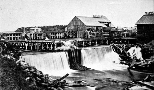
From Wiki:

Minneapolis developed around Saint Anthony Falls, the highest waterfall on the Mississippi River, which was used as a source of energy. A lumber industry was built around forests in northern Minnesota, and 17 sawmills operated from energy provided by the waterfall. By 1871, the river’s west bank had 23 businesses, including mills for flour, wool, cotton and paper. 

Due to the occupational hazards of milling, by the 1890s, six companies manufactured artificial limbs.

Wow.  In case you skimmed over that last sentence, go back and check it out. And yes, eventually there was major labor unrest in Minneapolis (during the 1930s) that resulted in enhanced workers’ rights.  Back to Wiki:

The use of water power in Minneapolis between 1880 and 1930 was described as “the greatest direct-drive waterpower center the world has ever seen.”  Minneapolis was the nation’s leading flour producer for nearly 50 years, and got the nickname “Mill City.”  As a result of the flour mills, Minneapolis is the birthplace of General Mills and Pillsbury.

So why haven’t St. Paul and Minneapolis become one city? From the local CBS News station:

As the milling industry took off in Minneapolis in the late 1800s, Minneapolis surpassed St. Paul’s population. But the two cities remained distinct.  Part of that reason is distance. During the 1800s, the two Cities were 14 miles apart – a full day’s carriage ride along the river road.  (As the crow flies, the cities are only 7 miles apart).

The demographics of the Cities were also different. St. Paul was more Catholic and Democratic, while Minneapolis was more Protestant and Republican. Politicians weren’t interested in losing political power by merging.

More recently, the rivalry has died down and the Twin Cities have become an established entity; the Cities now cooperate politically and economically.

Speaking of politics, Wiki tells us that the town of Victoria (closest to my landing) has consistently voted Republican since 1964.  I also checked out St. Bonifacius (the second-closest town to my landing).  Funny thing – the town has voted consistently Democratic since 1984.  Whatever . . .

I sent the OD to get a look at St. Anthony Falls.  He left the turkey behind, then found one of those blue dots where he could get a look:

Here’s what he saw:

The concrete-lined spillway you see was constructed to prevent riverbed erosion. Just behind the OD is a lock, so that boats can make their way from one side of the falls to the other.

The OD sought out another nearby blue dot along the lock.  He looked towards the river, and saw this guy, obviously posing:

Strangely, his face isn’t blurred out.  Could he be the photographer, operating the camera remotely via the cell phone in his hand?  The OD simply turned around, and he was mystified to see the same guy, evidently in two places at the same time!

He was a little freaked out, but figured he was ready for a different blue dot.  Well, he really freaked out when he looked out towards the river:

He turned around to check out the lock, and it only got worse:

The OD let me know he had had enough of Minneapolis and was more than ready for my next landing location.

It’s time for a couple of lake shots posted on GE.  First this, by Prabhakar Vangala, of Lake Auburn, right next to my landing:

I’ll move over to Stieger Lake, just a half mile east, for this lovely shot by Angel Estrada:

That’ll do it . . .

KS

Greg

© 2023 A Landing A Day

Posted in Uncategorized | Tagged: , , , , , , , | Leave a Comment »

Groesbeck, Texas

Posted by graywacke on January 20, 2023

First timer? In this formerly once-a-day blog (and now pretty much a once-a-week blog) I use an app that provides a random latitude and longitude that puts me somewhere in the continental United States (the lower 48).  I call this “landing.”

I keep track of the watersheds I land in, as well as the town or towns I land near.  I do some internet research to hopefully find something of interest about my landing location. 

To find out more about A Landing A Day (like who “Dan” is) please see “About Landing” above.  To check out some relatively recent changes in how I do things, check out “About Landing (Revisited).”

Landing number 2607; A Landing A Day blog post number 1052

Dan:  Today’s lat/long (N31o 22.757’, W96o 21.757) puts me in central-east Texas:

Here’s my local landing map:

Zooming back just a little:

You can see that quite recently, I landed quite nearby.  Quite strangely, I didn’t even mention Groesbeck, so it’s about time.  [I hope you noticed that I quite proudly used four “quites” in just three sentences.]

Anyway, you can see that it is 99.9% percent certain that runoff from my landing spot ends up in Lake Limestone (good enough for ALAD).  Lake Limestone is the dammed-up Navasota River (4th hit). 

Here’s a streams-only map showing that the Navasota discharges to the Brazos (37th hit) on to the G of M:

Google Earth (GE) Street View coverage is lousy near my landing.  All I could do is coax the Orange Dude to make his way south and find a bridge over the Navasota:

With 100% confidence in the Texas DOT, I had the OD find a sign announcing the Navasota River:

The water you see is likely some minor flooding; the OD checked out the main channel but found that it’s covered by a dense canopy.  In his opinion, there was nothing worth seeing . . .

Moving up to Groesbeck.  As per usual, it was named after some railroad executive.  But potentially much more interesting is this from Wiki:

Old Fort Parker Historical Site on the north side of Groesbeck is preserved to tell the story of Cynthia Ann Parker, who was captured by (and lived for many years with) the Comanches.  She became the mother of Quannah Parker, the last Comanche chief.

Here’s a GE shot of the fort, which is a reconstruction of the original 1834 fort.  The walls of the fort enclosed about an acre of land:

From the Historical Marker Database website, here are a couple of photos (by James Hulse):

And from the same website here are some excerpts from the historical marker at the site:

The stockade-blockhouse fortress that you see here today is a replica of the original fort built in 1834 by eight or nine Illinois families who had come to the Mexican state of Texas in 1832 and 1833. In this part of Texas, which was then a wilderness, the fort with its log cabins located inside the walls offered security to the families who worked their fields located just outside the fort.

On May 19, 1836, shortly after three of the men left to work in the fields, a band of 200 – 500 Comanche and Kiowa Indians attacked the fort. Benjamin Parker was the first to be killed as he approached the band in an attempt to buy time for others to escape.  He and four more men were killed.

One woman managed to leave the fort and warn the men working in the fields, who in turn alerted four neighbors. The Indians rode away at the approach of armed men.

In my own words:

In all, about 30 people were associated with the Fort.  Five men were killed, and two women and three children were captured in the attack. The five captured included:

Cynthia Ann Parker, 9; daughter of Silas Parker (much more about her later)

John Richard Parker, 6; Cynthia’s brother.  Held 6 years by a different Comanche band and then ransomed back in 1842.  At age 12, he was unable to adapt to white society, and ran back to the Comanche.  Later, he was part of a Comanche raid in Mexico where he contracted smallpox.  The war party left a captive Mexican girl to care for him; he recovered and then restored her to her family, and spent the remainder of his life in Old Mexico after marrying her.

Rachel Plummer, 17; Cynthia’s cousin, married to Luther Plummer.  She was held two years before being ransomed and returned to her husband.  She wrote a sensational best-seller “Rachael Plummer’s Narrative of Twenty-One Months’ Servitude as a Prisoner Among the Comanche Indians.”  She died in childbirth two years after her ransom.

James Plummer, 1, Rachel & Luther’s son, held by a different Comanche band than his mother’s.  James wasn’t ransomed until after his mother’s death, so she never knew of his fate.  He was ransomed at age 7 in 1842, and returned to his grandfather, James Parker.  James refused to return the boy to his father Luther, claiming that Luther paid none of the ransom.  Luther meanwhile remarried, and didn’t pursue the matter. 

Returning to Cynthia Ann Parker, who was captured at age 9.  From Wiki:

Cynthia became assimilated into the tribe. She was adopted by a Tenowish Comanche couple, who raised her as their own daughter. She became Comanche in every sense, and was renamed Naduah, or “someone found.” She married Peta Nocona, the chief who led the raid on Fort Parker. They enjoyed a happy marriage. As a tribute to his great affection to her, he never took another wife, although it was traditional for chieftains to have several wives. They had three children: Quanah, who became the last free Comanche chief, another son Pecos (Pecan), and a daughter Topasannah (Prairie Flower).

So.  She led quite the life.  Raised as a white Texan until she was 9 years old, she experienced unbelievable trauma when the Comanches attacked.  One can only presume that the Comanche couple that adopted her were loving parents who did all they could to help her to assimilate into the tribe. 

Did she live happily ever after?  Not a chance . .

She and her husband Nocona lived in the heart of Comancheria (a place I had never heard of).  From MyComancheria.com, this map:

From 1750 – 1850, roughly 30,000 Comanches resided in and defended Comancheria, sometimes referred to as the Comanche Empire.  The population (and power) of Comancheria began to decline in the 1840s, due to disease and the encroaching white presence.

So Cynthia Ann (Naduah), lived an apparently peaceful life from 1836 to 1860.  As mentioned above, she married Peta Nocona (a chief) had three children; two sons and a daughter.  In December of 1860, Naduah’s life was tragically turned upside once again by what was generally known as the “Battle of Pease River,” but which is more aptly termed the “Pease River Massacre.”

From Wiki:

The Battle of Pease River occurred on December 18, 1860, near the present-day town of Quanah, Texas [named after the Comanche Chieftain, Naduah’s son], and within site of the Medicine Mounds, holy to the Comanche.  A monument marks the site where a group of Comanche Indians (mostly women and children) were killed by a detachment of Texas Rangers and militia under Ranger Captain “Sul” Ross. The Indian camp was attacked as retaliation against recent Comanche attacks on white settlers.

This raid is primarily remembered as the place where Cynthia Ann Parker was recaptured from the Comanche who had adopted her after capturing her twenty-four years earlier.

Here’s a map showing the proximity of the Pease River site to the town of Quanah and to “Medicine Mound,” a series of three hills sacred to the Comanche:

Here’s a close-in shot of the site, the location of which is described in detail in one of the historic references about the site, as a quarter to half a mile up Mule Creek from its confluence with Pease River; a sheltered area with flat land for the horses to graze.

Lawrence Sullivan (Sul) Ross was a politician at heart (and ended up as the 19th governor of Texas), and he claimed a hero’s role in a battle  According to his story, Naduah’s husband, the Comanche Chief Peta Nocona and several other braves were killed.  For many years, his role as a hero was unchallenged.  However, Quannah vigorously disputed that account, saying that he was with his father when he died of disease several years later.  Tragically, Peta Nocona was never re-united with his wife.

More recent research strongly suggests that few men were present at the Pease River site, but mainly women and children who were dressing buffalo meat, many of whom (6 – 12) were slaughtered.  Evidently, Peta Nocona, his sons, and several other men were out hunting when the attack occurred.

Ross apparently suspected that Cynthia Ann would be present, and apparently recognized her by her blue eyes and hair color; she and her daughter were captured by Ross.  She was subsequently returned to her uncle Isaac Parker. 

I found an article in the Texas Monthly by W.K. Stratton, who interviewed Ron Parker, Peta Nocona’s great-great-grandson (and Quanah’s great grandson).  Here are some excerpts:

Ron Parker and I followed the cattle trails near the creek and river. We stopped only once, when we flushed about twenty wild turkeys from the brush. As we walked on, Parker shared the version of the “battle” he’d been taught by the Comanche.

“Pease River was a Ranger-led massacre,” Parker told me. His great-great-grandfather Peta Nocona, he said, was nowhere near the action. “At the time, Nocona was with his teenage sons Quanah and Pecos and other warriors.” Nocona died several years later near the Antelope Hills in Oklahoma, Parker said. “He died of an infection.”

The more materials I gathered on the events at Pease River, the more credible Parker’s version seemed. In an interview in 1928, one of the Rangers who took part, Hiram B. Rogers, also described a massacre: “I was at the Pease river fight, but I’m not very proud of it. That was not a battle at all, but just a killing of women.” I wondered how a massacre had been inflated into a great Ranger victory. I would soon learn that Ross himself was largely responsible.

Back to Cynthia Ann’s story, from Wiki:

Isaac was unable to positively identify this fraught captive as his niece; however, she remembered a few words of English and finally convinced Parker she was his niece.  Although Cynthia Ann was lovingly cared for by her white family, she was unhappy in her new surroundings. She attempted to rejoin the Comanches on at least one occasion.  She believed that her husband and both of her sons were lost, Her daughter Topasannah died of influenza in 1864. 

Ironically, both of Cynthia Ann’s two sons escaped the Battle of Pease River, but the younger one died later before he could be returned to his mother.  Her oldest son, Quanah became a famous chieftain among the Comanches, and became the last of their war chiefs. The reason he was not reunited with his mother is not known, although at the end of his life, he directed that his mother and sister’s remains be disinterred and reburied in the Indian burial ground next to his grave site.  

Cynthia Ann died by self-imposed starvation in 1871.

I’m wrung out after immersing myself in Cynthia Ann’s (or should I say Naduah’s) story.  I dutifully searched GE around my landing for a closing picture, but came up empty.  I think it’s more appropriate to close with this photo of Naduah nursing her daughter in 1861:

I find this to be a striking photograph.  Photography in 1861 was a very formal affair, with a professional photographer.  I find it amazing that the decision was made (likely going along with Naduah’s wishes) to photograph her nursing her daughter.  I can imagine a crying daughter and an impatient photographer.  Mom knew how to make her quiet down . . .

That’ll do it . . .

KS

Greg

© 2023 A Landing A Day

Posted in Uncategorized | Tagged: , , , , , , , , , | 1 Comment »

Ocracoke Island, North Carolina

Posted by graywacke on January 13, 2023

First timer? In this formerly once-a-day blog (and now pretty much a once-a-week blog) I use an app that provides a random latitude and longitude that puts me somewhere in the continental United States (the lower 48). I call this “landing.”

I keep track of the watersheds I land in, as well as the town or towns I land near.  I do some internet research to hopefully find something of interest about my landing location. 

To find out more about A Landing A Day (like who “Dan” is) please see “About Landing” above.  To check out some relatively recent changes in how I do things, check out “About Landing (Revisited).”

Landing number 2606; A Landing A Day blog post number 1051

Dan:  Today’s lat/long (N35o 13.936’, W75o 52.788) puts me in east-central-ish North Carolina:

If it looks like I landed in the water, it’s because I did:

Zooming back to see all of the Outer Banks and Pamlico Sound (the body of water in which I landed):

This was one of those situations where I, the all-powerful ALAD authority, could either deem the landing to be a water landing and try again, or keep it and call it North Carolina.  My choice is obvious.

Brutal watershed analysis:  Pamlico Sound; Atlantic Ocean.

 On my local landing map, I noticed that there was no bridge across the inlet between Hatteras and Ocracoke Islands.  Curious about the apparent ferry, I found out that there is, in fact, the Hatteras-Ocracoke Ferry, operated at no charge by the State of North Carolina. 

Heading over to Google Earth (GE), it was apparent that the ferry could not navigate the straight line across the inlet, thanks to all of those tricky sandbars:

Looking more closely, I could see two ferry boats:

Obviously, here’s the route the ferries must take to stay in deep water:

I was checking out the driving route from my house in New Jersey to Ocracoke on Google Maps (which takes 9 hours and 46 minutes). I zoomed in on Hatteras & Ocracoke:

Geez. Even Google Maps knows about the shallow water at the inlet!

Joel Elliott posted this ferry boat shot on GE:

Although I was totally distracted by the ferry, I needed to send the Orange Dude on a mission to get a look at my landing. None of his road-based locations provided any water views, and strangely, the GoogleMobil didn’t hop on the ferry. However, individual GoogleCam shots were taken at several locations near the inlet (marked by blue dots), and the OD found one where he could, in fact, get a look at my landing:

And here’s his view:

Wiki lets us know that Ocracoke was for a time (1717-1718) used by Edward Teach (better known as Blackbeard) as the base for his pirate operations, and in 1718, he was killed in a battle near the Ocracoke Inlet (at the southwest end of the island).  From Epic History TV, here’s an interesting video that provides an overview of Blackbeard’s pirate days:

I found an article from Time.com by Eric Jay Dolin about the death of Blackbeard.  Here are some excerpts:

British naval Lieutenant Robert Maynard was sent by Virginia Governor, Alexander Spotswood, to kill or capture Edward Teach (aka Blackbeard).

Tipped off that Blackbeard and his men might be moored off North Carolina’s Ocracoke Island, Maynard’s forces departed Williamsburg on Nov. 17, 1718, and sailed down the James River. Although Maynard would have preferred to have the services of a British man-of-war to take on the fearsome pirate, such a ship could not navigate the shallow waters of Pamlico Sound, so Maynard had to rely on the services of two small sloops, the Ranger with 25 men and the slightly larger Jane, with 35 men, including Maynard.

While these sloops could easily navigate the shallow and twisting channels around Ocracoke, they had no cannons, which meant that Maynard’s men would have to rely on their personal weapons in going up against a foe with nine cannons at his disposal.

By the afternoon of Nov. 21, Maynard’s sloops had reached the southern tip of Ocracoke. They soon spied two sloops at anchor just inside the Orcracoke Inlet. With evening coming on, Maynard anchored the Jane and the Ranger for the night.

Unaware of the force amassed nearby, Blackbeard, along with about 20 of his men on board the sloop Adventure, spent that evening drinking and carousing with local trader Samuel Odell, who had arrived earlier on his own sloop. The following morning, the sea was calm and the winds very light, and the only sounds to be heard were birds greeting the break of day.

At nine, Maynard ordered the Ranger to make way for the sloops, still not certain that one of them was Blackbeard’s. The Jane followed close behind. Not long after setting out, the Jane grounded, and then the Ranger did the same. Men on both ships began furiously throwing heavy materials overboard to lighten the load; both sloops were soon afloat again, but that precious element of surprise had been lost.

Here’s a GE shot of the Ocracoke Inlet showing where Blackbeard was anchored and where the battle was fought.  Although not as sandbar-ridden as the Hatteras Inlet, it’s easy to see how unknowing sailors could run aground:

Even if they had been in drunken stupors, Blackbeard’s men would have been alerted by all the nearby commotion. Realizing that he was under attack, Blackbeard ordered his men to cut the Adventure’s cable and get underway. To intimidate their attackers, the pirates began shooting at the approaching sloops. Blackbeard’s Adventure could not make way due to calm winds; the Ranger headed straight for the ship, with the Jane right behind, its men straining at their oars to close in.

When the Jane pulled to within about half a pistol shot of the Adventure, there was a brief conversation between Maynard and Blackbeard. Blackbeard said he was a loyal British citizen, and if left alone, he would not attack.  Maynard told Blackbeard it was him he wanted, dead or alive.  According to Maynard, in reply Blackbeard “drank damnation to me and my men, whom he styled sniveling puppies, saying he would neither give nor take quarter.”

As soon as the talking was over, Blackbeard took full advantage of his superior firepower and unleashed a booming broadside of shot that killed the commander of the Ranger and severely wounded five of his men, including the second and third in command.

Not wanting to expose any more of his men to blasts from Blackbeard’s cannons, Maynard ordered all of them below the Jane’s decks, while he went into the cabin at the stern of the ship. Maynard was not only retreating to get out of harm’s way, but he was also setting a trap. Before going to the cabin, Maynard ordered the pilot and a midshipman to stay on deck and alert him as to what Blackbeard was doing. If it worked out as Maynard hoped, the pirates would soon come to him.

Seeing that the Jane’s decks were clear, Blackbeard thought that his cannons had done their deadly work, and the battle was all but won. To deliver the coup de grâce, Blackbeard brought the Adventure alongside the Jane and led his men over the rails, with a rope in his hand to lash the vessels together. As soon as Blackbeard was aboard, the pilot signaled Maynard, who, along with 12 of his men, rushed to the main deck, catching the pirates off guard.

During the six-minute melee that ensued, the combatants slashed, thrust, and shot at one another at close range, their grunts, screams, and groans intermingled with the sounds of clashing steel and exploding gunpowder.

When the smoke finally cleared, Maynard was unharmed, but the great Blackbeard lay dead, and the rest of his men who had followed him onto the Jane were either killed or severely wounded.

Live by the sword . . . die by the sword.

From VisitOcracoke.com is this video about the old-time dialect spoken on Ocracoke.

I’ll close with a couple of Ocracoke shots posted on GE.  First this, by Curtis Wright of the ferry terminal in the town of Ocracoke:

And then this of a typical stretch of Ocracoke beach, by Joanna Lorek:

That’ll do it . . .

KS

Greg

Posted in Uncategorized | Leave a Comment »

Creede, Colorado (revisited)

Posted by graywacke on January 5, 2023

First timer? In this formerly once-a-day blog (and now pretty much a once-a-week blog) I use an app that provides a random latitude and longitude that puts me somewhere in the continental United States (the lower 48).  I call this “landing.”

I keep track of the watersheds I land in, as well as the town or towns I land near.  I do some internet research to hopefully find something of interest about my landing location. 

To find out more about A Landing A Day (like who “Dan” is) please see “About Landing” above.  To check out some relatively recent changes in how I do things, check out “About Landing (Revisited).”

Landing number 2605; A Landing A Day blog post number 1050

Dan:  First, a word of apology about the fact that it has been nearly two weeks since I last posted.  As you know, I’ve been posting religiously every Friday for well over a year (with a minor exception here and there).  I’ll confidently predict that my posting-every-Friday schedule will return (beginning eight days from now), and then continue into the indefinite future . . .

Today’s lat/long (N37o 45.359’, W106o 33.148) puts me in southwestern Colorado:

Here’s my local landing map:

My streams-only map shows that I landed in the watershed of Embargo Creek, on to the Rio Grande (56th hit).  Simple as that:

To put things in a regional context, here’s a map showing how the Rio Grande makes its way through New Mexico to the Texas – Mexico border:

Heading over to Google Earth (GE), here’s a shot showing where the Orange dude put himself to get a look at the Rio Grande near my landing:

He got lovely views of the river!  Looking downstream:

Looking upstream:

About a mile away, he found a spot where he could more-or-less look up the Embargo Creek Valley:

And here’s his view:

It turns out that I landed near Creede back in 2013 (about five miles north of today’s landing). I borrowed a little here and a little there from that post, but I’m not going to bother telling my readers (all eleven of you) what’s old and what’s new, although I’ll admit that the following piece about the triple point comes from 2013 . . .

Getting back to watersheds, I found this:

Hmmmm.  The Gunnison, the Arkansas and the Rio Grande.  Well, the Gunnison flows to the Colorado and the Colorado flows to the Gulf of California (sort of; see my Yuma AZ post for more on this sore subject).  The Arkansas flows to the Mississippi, and the Rio Grande flows to the western Gulf of Mexico.  Man.  Three widely-separated watersheds . . .

Guess what is 100% certain?  That there’s a Triple Point!!  That’s right, it is absolutely (mathematically) inevitable that there is a mountain top near my landing where a hypothetical raindrop, landing exactly at the summit, will split into thirds:  one third will head to each watershed.

I did a little research, and found that the triple point mountain is called . . . Headwaters Hill!  Here is a GE shot showing its location (about 40 miles from my landing):

In 2001, the U.S. Board of Geographic Names (part of the Geologic Survey), approved the name “Headwaters Hill” based on an effort by Western Colorado State University and a Denver cartographer.  There aren’t many major triple points in the U.S., and it’s cool that this one got an official moniker.

Geez.  It was just two landings ago that I landed near the triple point of three watersheds in Virginia/North Carolina and admitted to my obsession with triple points . . .

Moving on to Creede.  From the Creede & Mineral County C of C website:

In 1890, the Upper Rio Grande Valley’s destiny changed dramatically. Nicholas Creede discovered a high-grade silver vein on Willow Creek, a tributary of the Rio Grande. The great rush was on! The boom camp’s population quickly swelled to 10,000.  Slab cities and tent towns like North Creede, East Creede, String Town, Jimtown, and Amethyst seemed to appear overnight. Fortunes were extracted from mines with colorful names such as Amethyst, Holy Moses, Commodore, Last Chance, and Kentucky Belle.

 Here’s a back-in-the-day shot (1920) of Creede (from the C of C website):

Compare this with a modern shot taken from the same spot (from Wiki):

For all of you regular followers of ALAD, you may be aware of my frequent run-ins with explorer and bon vivant John C. Fremont.  It turns out that in 1848, Fremont and 35 men made a disastrous attempt to cross the San Juan Mountains in the dead of winter while searching for a route for the first cross-country railroad.  He followed the Rio Grande, and then headed up Embargo Creek (going right past my landing).  He was originally headed for Saguache Creek (about 20 miles further north), but a local guide convinced him to try the Rio Grande / Embargo Creek Route.

It was a bad choice, as the route would be nearly impassable in a normal winter and the winter of 1848 was particularly harsh, with six to seven foot drifts in the mountains. Eleven of the 36 men and all of the 120 mules died on the trip. For several weeks all the men had to eat was mule.

There was no low pass across the mountains, and he ended up at an elevation of 11,000’ where he camped, attempting to wait out the winter.  Here’s a GE map, showing where Fremont wintered (only about 8 miles from my landing):

Mr. Fremont kept a journal.  From that journal:

It is October 1848. I and 35 men, 150 mules, and supplies are leaving St. Louis, Missouri to search for a southern train route through the Rocky Mountains. Many of my men have been with me before on my previous expeditions and will provide the necessary expertise and experience needed. While much of my route is known to me and my crew, our exact path through the headwaters of the Rio Grande descending on to the Colorado River and so across the Wasatch Mountains has not been decided.

But I am hopeful that I can find an experienced guide along our journey. This is especially important because we are beginning our journey in late autumn to test the practicability for winter use of this route for a railroad. My previous trips through the Rocky Mountains have provided many with the geographical knowledge of the area further to the north, and I reminisce from my journals on the beauty of this land.  [Check this out – he’s quite poetic . . .]

August 7, 1842 – We left our encampment with the rising sun. As we rose from the bed of the creek, the snow line of the mountain stretched grandly before us, the white peaks glittering in the sun. They had been hidden in the dark weather of the last few days, and it had been snowing on them while it rained on us. We crossed a ridge, and again struck a beautiful, swift stream, with a more open valley, timbered with beech and cottonwood.

 It now began to lose itself in the many small forks which make its head; and we continued up the main stream until near noon, when we left it a few miles to make our noon halt on a small creek among the hills, from which the stream issues by a small opening. Within was a beautiful grassy spot, covered with an open grove of large beech trees, amongst which I found several plants that I had not previously seen!

June 11 and 12, 1844 – We have before our eyes the high mountains which divide the Pacific from the Mississippi waters; and entering here among the lower spurs or foothills of the range, the face of the country began to improve with magical rapidity. Not only the river bottoms, but the hills, were covered with grass; and among the usual varied flora of the mountain region, these were occasionally blue with the showy bloom of a lupine [bluebonnet].

In the course of the morning we had the first glad view of buffalo and welcomed the appearance of two old bulls with as much joy as if they had been messengers from home. A band of elk broke out of a neighboring grove; antelopes were running over the hills; and on the opposite river plains herds of buffalo were raising clouds of dust.

The country here appeared more variously stocked with game than any part of the Rocky Mountains we had visited; and its abundance is owing to this excellent pasturage.

Even now in October, I am getting reports that snow is already deeper in the mountains than has been known so early in the season for a long time, and it is predicted to be a severe winter. Still, I am in no way discouraged by the prospect, and believe that we shall succeed in forcing our way across!

Although not mentioned above, there was cannibalism amongst a smaller party that broke away from the main group trying to find a way out.

Back in 2013, there was a photo posted on GE by Ben Will, supposedly of Fremont’s winter camp:

I found an article on Alamosa.com (Alamosa is a town about 40 miles southeast of my landing), written by someone attempting to follow Fremont’s route.  Here are some excerpts from that article about the author’s early November trip:

Following the road up Embargo Creek is deceiving. The gentle valley is open and inviting and the distant high ridges do not look as if they would have any difficult terrain to negotiate to get up there, nor do any towering rugged peaks appear beyond those level ridges. I imagined scouting for a rail route and thinking that I could do the cuts along the creek with dynamite and human power, then add switchbacks to the narrow gauge track up the mountain ridges, to the top, and beyond.

I drove the well graded dirt road along the creek  about 13 miles off US 160 [see my local landing map; the north-south road appears there].  The road deteriorated to a trail my Jeep could handle for a couple more miles.  Then, I parked in a clearing by the creek and began my excursion on foot. The first storm of the winter was hovering on the Continental Divide a few miles to my west but I was protected from the wind on the trail that was now in a narrow deep canyon with steep hillsides.

Except for the lack of deep snow cover, I was seeing the valley exactly as the expedition had seen it. Beautiful, rocky, many tree roots and large stands of beetle kill pine on the hillsides, aspens along the creek. I came to an active beaver pond with several aspen trees that were ‘works in progress.’ The expedition would have seen the similar sights earlier in the fall of 1848 had they gotten here sooner.

Soon, I wandered into the woods after I had traveled up the rugged terrain perhaps two miles and tried to guess where that size of group would have camped. This area would not have been easy trekking in deep snow!

I stood in one flat clearing and pondered about what the men were thinking. They were bogged down in the snow and they ran out of food. Mules and men began dying. I stood there in the early November cold, alone, the sky a deepening gray, the afternoon wearing on, observing and hypothesizing.

I had the luxury of returning to my car and back to a warm home. The expedition did not. Someone must have finally said after weeks of enduring, that their best chance of rescue was to send someone to Taos as quickly as possible, get food and other essentials for survival and return. But, Taos is 130 miles down the Rio Grande! In January, now on foot, in snow, no food… How well any of us would have done to survive on that expedition, we cannot know!

My conclusion to this adventure/experiment? Fremont, with his ego, was not always capable of smart decisions. As I looked at the terrain further up the creek, there was no way that expedition was going anywhere! I can’t imagine Fremont’s thought process. Small tributaries of larger rivers, of which Embargo Creek is to the Rio Grande, rarely go anywhere toward a natural and inviting path to travel for a railroad, or even on horseback.

Here’s a shot of Embargo Creek upstream from my landing, posted on GE by Lucius Verde:

I mentioned earlier that Fremont intended on heading for the Saguache Creek valley, further north.  Five years later, another group led by John Gunnison headed up the Saguache for the same reason – trying to find a rail route across the Rockies.  Here’s a drawing of the Saguache Valley adapted from a sketch made by the scouting party:

This route also traversed a high pass, Cochetopa Pass (“COO-CHE-TO-PA” on the above), at a little over 10,000 in elevation.  Here’s a map, showing the approximate route of both explorers:

The group successfully traversed Cochetopa Pass, and traveled down the Gunnison River into Utah where Gunnison was killed by Indians.  His second-in-command decided  the route over Cochetopa Pass was an unacceptable route for a railroad, and that the only feasible route was much further north across southern Wyoming.  This route was finally selected, and the first transcontinental railroad was completed in 1869:

I’ll close with this lovely shot of the Rio Grande Valley, a few miles southeast of my landing, posted on GE by Virgil Hammock:

That’ll do it . . .

KS

Greg

© 2023 A Landing A Day

Posted in Uncategorized | Tagged: , , | Leave a Comment »