I keep track of the watersheds I land in, as well as the town or towns I land near. I do some internet research to hopefully find something of interest about my landing location.
To find out more about A Landing A Day (like who “Dan” is) please see “About Landing” above. To check out some relatively recent changes in how I do things, check out “About Landing (Revisited).”
Landing number 2663; A Landing A Day blog post number 1108
Dan: Today’s lat/long (N40o 1.754’, W79o 8.065) puts me in southwest Pennsylvania:
Here’s my local landing map:
Somerset is far and away the largest town, but it just didn’t have the chops to go titular.
My streams-only map shows that I landed in the watershed of the West Branch of Coxes Creek; on to Coxes Creek.
Zooming way back:
Coxe Creek discharges to the Casselman River (1st hit ever!); on to the Youghiogheny (1st hit ever!); then to the Monongahela (5th hit; 187th river on my list of rivers with five or more hits); to the Ohio (164th hit); to the MM (1037th hit).
The Orange Dude could get a look at the West Branch:
He looked upstream towards my landing:
He also looked downstream:
I saw Rockwood on my local landing map, and realized that I had been there before. Way back in the day (in the 1980s), I was doing environmental work for Texas Eastern Corporation, which owned and operated a natural gas pipeline system that transmitted natural gas from Texas to New Jersey. There was a compressor station in Rockwood, which functioned as a pumping station to boost the pressure in the pipeline and keep the gas flowing.
There were 18 Texas Eastern compressor stations in Pennsylvania, and the turbines in the compressor stations were lubricated with PCB oil. Inevitably, some of the oil leaked into the pipeline, which then accumulated in the low spots along the pipeline. The accumulated oil had to be cleaned out, so Texas Eastern would periodically send “pigs” through the pipeline. A pig is essentially a cylindrical device cleverly designed to inspect the pipeline and collect accumulated fluids at the same time. The pig is carried through the pipeline by the flow of gas (from compressor station to compressor station), scooping up the oil as it goes.
The pig would surface at the downstream compressor station, loaded up with PCB oils. So, the pig needed to be emptied, and the cheapest and easiest way to do it was to dump the contents in an earthen pit.
Bad idea.
For about a year and half, me and about a hundred other people (including my future wife Jody) sampled the hell out of the soils and groundwater and figured out the extent of PCBs associated with each of 50-odd disposal pits located at the 18 compressor stations spread across Pennsylvania (including Rockwood).
OK, OK. Neither Jody nor I did any of the actual sampling, but somebody had to organize and manage the effort and then look at all of the data and figure out what was going on. I could go on and on with stories, but I won’t . . .
Moving on to Berlin. Wiki tells us that there was a riot in Berlin in June of 1794 as part of the Whiskey Rebellion. OK, I’ve heard of the Whiskey Rebellion, but don’t know a thing about it. From Wiki:
The Whiskey Rebellion (also known as the Whiskey Insurrection) was a violent tax protest in the United States beginning in 1791 and ending in 1794 during the presidency of George Washington. The so-called “whiskey tax” was the first tax imposed on a domestic product by the newly formed federal government.
The tax applied to all distilled spirits, but consumption of American whiskey was rapidly expanding in the late 18th century, so the excise became widely known as a “whiskey tax.” Farmers of the western frontier were accustomed to distilling their surplus rye, barley, wheat, corn, or fermented grain mixtures to make whiskey. These farmers resisted the tax.
Throughout Western Pennsylvania counties, protesters used violence and intimidation to prevent federal officials from collecting the tax. Resistance came to a climax in July 1794, when a US marshal arrived in western Pennsylvania to serve writs to distillers who had not paid the excise. The alarm was raised, and more than 500 armed men attacked the fortified home of tax inspector John Neville.
Washington responded by sending peace commissioners to western Pennsylvania to negotiate with the rebels, while at the same time calling on governors to send a militia force to enforce the tax. Washington himself rode at the head of an army to suppress the insurgency, with 13,000 militiamen provided by the governors of Virginia, Maryland, New Jersey, and Pennsylvania.
The rebels all went home before the arrival of the army, and there was no confrontation. About 20 men were arrested, but all were later acquitted or pardoned.
At the end of the day, it was much ado about nothing . . .
Here’s a shot from Wiki of a tax collector being tarred and feathered in western Pennsylvania:
Also from Wiki – this painting of George Washington reviewing the troops he was leading to put down the rebellion:
Shanksville is well-known solely because it was near Shanksville that United Flight 93 crashed on 9/11. Flight 93 originated in Newark and was headed to LAX when it was hijacked. The hijackers intended on crashing the jet into either the White House or the Capitol (I bet it was the Capitol). Flight 93 was the last of four flights hijacked, and the passengers had time to communicate via phone with loved ones who told them about the World Trade Center and let them know what was going on. We all know the story: the passengers decided that they had no choice but to rush the cockpit and at least attempt to retake control of the jet.
Here’s the flight path:
And a video put out by the National Park Service about the Flight 93 Memorial:
I’ll close with this shot posted on GE by J. L. Ruthig of a barn about a mile north of my landing:
I keep track of the watersheds I land in, as well as the town or towns I land near. I do some internet research to hopefully find something of interest about my landing location.
To find out more about A Landing A Day (like who “Dan” is) please see “About Landing” above. To check out some relatively recent changes in how I do things, check out “About Landing (Revisited).”
Landing number 2662; A Landing A Day blog post number 1107
Dan: Today’s lat/long (N35o 20.788’, W108o 39.278) puts me in northeast New Mexico:
Here’s my local landing map:
Here’s my local landing map:
(The only reason I circled Gallup is because it’s the largest and best-known town.)
We can check out my most-local watershed on Google Earth (GE):
Hmmm. Note that the drainage terminates in an internal basin. I’ll take a closer look using the Google Earth elevation tool in a bit, but first, here’s what the OD could see (looking downstream):
OK. Let’s take a look at this so-called internal basin (elevations are from the GE elevation tool):
You can see the path of the wash, downslope to the southwest from elevation 7007 to 7004. But then, unexpectedly, the wash seems to terminate in a basin, bounded to the southwest by a 50’ ridge. I must admit that I’m somewhat baffled.
OK. Here comes a reality check. I’m typing this sentence a day after I typed the above sentence about being baffled. I decided to roll up my sleeves and take a closer look. I mean, really! If there were a 50’ ridge blocking the wash, it would create quite the lake, albeit temporarily, given the dry climate. Based on the general lay of the land, I suspected that the ridge would be man-made. But based on GE, the high elevations extend for nearly a mile downstream. Drawing on my vast experience tracing drainage pathways on GE, I knew that there would be visual evidence of a lake or basin, and as a geologist, this mile-long area of high elevations in a valley made no sense. So, I thought I better turn to a good ol’ USGS map.
Looking at my local landing map, I saw that the town of Vanderwagen was the closest to my “internal basin.” So, I typed “Vanderwagen USGS map” into Google, and bingo! I found the map and I found the area of interest. Here ‘tis:
Well, lookee there. Right off – I didn’t land in the Nelson Wash watershed, but rather the Whitewater Arroyo watershed. My so-called internal basin is just north of where Nelson Wash flows into the Whitewater [Arroyo] – near where I pointed out the 7000′ elevation contour. I landed to the northeast, in the Whitewater watershed. There is absolutely no evidence of a higher-elevation blockage.
Here’s the bottom line: The GE elevation tool is flat out wrong. It shows an area of high elevations that extends about a mile down the middle of the Whitewater Arroyo. This area just doesn’t exist.
Unsurprisingly, I have no idea how this happened; but it’s time to move on and complete my watershed analysis: Whitewater Arroyo discharges into the Puerco River (3rd hit); on to the Little Colorado (23rd hit); on to the Colorado (202nd hit). Here’s a map:
Because I was close to the Continental Divide I included it along with drainage away from the Divide in both directions. Here’s a shot of the Divide on I-40:
As you can tell from the above, the Continental Divide is on a nearly-flat section of I-40 — hardly the classic image of the Continental Divide!
Moving on to Thoreau. I was immediately curious about the origin of the town’s name, so I Googled “Thoreau NM etymology.” Google has a new “AI” (Artificial Intelligence) feature that comes up first. Here’s a screen shot:
Notice the down arrows highlighted in blue? They provide the reference docs upon which the above paragraphs are based. So, I clicked on the down arrow after the second paragraph:
OMG! (Or I should say OMLG!). The AI feature found my October 2016 post where I discussed the origin of the town’s name! (I’ll admit that I forgot that I had previously landed near Thoreau.) Google searches are always incredible, but this one hit close to home! So, of course, I clicked on the blue box that featured A Landing A Day.
It took right to my post, and highlighted the piece that they lifted:
But wait: In my post, I mentioned Wikipedia, and then go on to say that locals maintain that “Thoreau” was named after some other person. AI took that and re-worded it to say “However, some locals claim that . . .”
AMAZING!
It took Google 0.32 seconds to find my post, extract the language and then re-word it!
There’s more! In the blue box that references my post are three vertical dots. I clicked on the dots, and here’s what came up:
Wow: “I am a nerd with nothing better to do than land every day.” I don’t recall this quote, so of course I had to find it.
Well, I found it:
Phew. Now, I’ll steal some stuff from my afore-mentioned 2016 post . . .
So what about Thoreau? From Wiki:
The population was 1,863 at the 2000 census. It is majority Native American, primarily of the Navajo Nation, as this community is located within its boundaries.
Practically all residents pronounce the town’s name like “thuh-ROO.”
[Not as fans of the American philosopher/writer might expect.]
The town is not named for Henry David Thoreau, though this is a common misconception. A history of the town was compiled by local author Roxanne Trout Heath in her 1982 book Thoreau, Where the Trails Cross!
Remember this. Wiki says the town wasn’t named for Henry David, and they use Roxanne Trout’s book as the source.
All well and good, but how did the town get its name? After stating that the town is not named after Henry David, there’s not a word about who it is named for. I Googled the book title, to no avail. But then I found this, from TheRoute-66.com, about Thoreau (the town):
The Mitchel brothers, William and Austin moved to the area in 1890. They had their eyes on the forests on Zuni Mountains, where they wanted to build a sawmill and sell the lumber in the Southwest. They platted a town that they named “Mitchel”. But their business did not prosper.
In 1896 Talbot and Frederick Hyde, heirs to the Babbit Soap fortune sponsored a archeology expedition in New Mexico. The Hyde Exploring Expedition set up its base in Mitchel and from there conducted excavations in Chaco Canyon until 1901.
Professor Frederick Ward Putnam of Harvard University was in charge of the expedition. The scientific expedition led to a growth in trading with the Navajo and the town was renamed as Thoreau by the Hyde brothers.
OK, so the Hyde brothers (from upstate New York, I think) named the town, and a Harvard professor was involved. The prof might think that Thoreau (after Henry David) might be a cool name for a town, what with Walden Pond being in the greater Boston area.
I then checked out Ancestry.com for Talbot Hyde (actually Benjamin Babbitt Talbot Hyde) and found that he took some courses at Harvard. Hmmm. Another vote for Henry Thoreau.
But the pièce de résistance came from a portion of TheRoute-66.com article that I initially missed (it was in a box off to the side):
Wikipedia denies that the town was named after Henry David Thoreau and the locals maintain that “Thoreau” was a person who worked for either the railway, the Mitchels or the US Army. However, the book Thoreau, Where the Trails Cross! by Roxanne Trout Heath (1982) affirms that it was named after the famous philosopher.
Now wait a second! Both Wiki and TheRoute-66 use the same source as the basis for opposite claims!
My vote goes solidly with TheRoute-66, considering the Boston connection for the folks that named the town . . .
Quick personal story about Henry David Thoreau. I have long been aware of the quote “The mass of men lead lives of quiet desperation,” from his book Walden. Way, way back in the day (many decades ago), I felt like one of those “mass of men.”
Many, many years later, (well beyond the time of quiet desperation), I was in a used book store, and came across Walden. I riffled the 352 pages with my thumb, and randomly stopped, then looked down at the page.
The absolute first words that I saw were “The mass of men lead lives of quiet desperation.”
Blew me away.
Being left-brained, I was immediately suspicious that many others had found that quote in that same book, causing the book to naturally open on that page. I held the book loosely and let it open naturally with no bias. Nope. It had no tendency whatever to open there. Out of 352 pages, some Higher Power decided I should see that quote for myself. . .
I’ll close with this shot posted on GE (south of my laniding) by “Joe:”
I keep track of the watersheds I land in, as well as the town or towns I land near. I do some internet research to hopefully find something of interest about my landing location.
To find out more about A Landing A Day (like who “Dan” is) please see “About Landing” above. To check out some relatively recent changes in how I do things, check out “About Landing (Revisited).”
Landing number 2661; A Landing A Day blog post number 1107
Dan: Today’s lat/long (N47o 28.993’, W106o 0.502) puts me in northeast Montana:
Here’s my local landing map:
We can check out my most-local watershed on Google Earth (GE):
I know that my drainage is going to that huge lake that is the dammed-up Missouri River (472nd hit; on to the MM, 1036th hit). But I found that Nelson Creek connects Garfield Coulee and the lake:
The Orange Dude couldn’t get anywhere close to my landing, but he did manage to get a look at Nelson Creek:
Here’s what he sees (although he visited at dusk):
To get a look at the Missouri River, I’ll head downstream from the reservoir and visit the Lewis and Clark bridge near the town of Wolf Point (see Wolf Point on my local landing map). Here’s what the OD could see from the bridge:
If the bridge looks decrepit, it is. Read on . . .
I found an article about the bridge on VisitMontana.com. Here are some excerpts:
For many years this was the only bridge over the Missouri River for 350 miles. It’s location has long been considered a strategic point. Lewis and Clark camped here in 1805 and an army engineer noted in 1860 that this was the logical place to build a bridge.
Tribal lands opened in 1913 and as homesteaders poured in, the only river crossing for man and beast was by ferry or over the ice in winter. In February 1926, the drowning of two teenagers crossing the ice in their Model T finally brought about successful lobbying.
The christening of the Wolf Point Bridge took place with great fanfare in 1930. In 1945, the 140th anniversary of the Lewis and Clark Expedition prompted changing the name to the Lewis and Clark Bridge.
The later twentieth century saw modern traffic changes and the narrow bridge was replaced. Its symbolic importance, however, prompted its preservation. Visible today from a distance of fifteen miles, the bridge appears as three ethereal puffs of gray against the prairie, representing a longtime dream that finally came true.
Now it’s time for the lead story for this post: the Fort Peck Dam. Here are some bullet points from various sources:
Built between 1933 and 1940
Dam is earthen; 250 feet high and 4 miles long (Wow. That’s a lotta dirt!)
Dam was built to generate hydroelectric power and for flood control
It cost $100 million – over $2 billion in today’s dollars
As many as 11,000 people were working on the dam at one time.
The town of Fort Peck was a “government town,” constructed for management and upper-level employees.
Five or six satellite towns were established to house and service the 11,000 workers.
I wanted the OD to take a look at the town of Fort Peck today, but check this out:
Hmmm. Seems peculiar that the Googlemobile scrupulously avoided the actual town streets. This is particularly strange when zooming back a little:
There’s much more coverage in an open area just east of town and below the dam. Here’s a close-up:
Here’s a couple of shots of what the OD could see:
Well, lookee there. The GoogleMobile guy hopped on a bicycle (not sure where he put the camera). Here’s another shot:
Life Magazine released its first issue on November 23, 1936. The cover story? The Peck Dam. The photographer Margaret Bourke-White was handed the assignment.
Here’s the Life Magazine cover (more about what you’re looking at in a bit):
Life.com has an article about the first issue; I’ll present some excerpts and some of Margaret Bourke-White’s photos. First this, a quote from Margaret’s autobiography:
A few weeks before the beginning, Harry Luce [magazine editor] called me up to his office and assigned me to a wonderful story out in the Northwest. Harry’s idea was to photograph the enormous chain of dams in the Columbia River basin that was part of the New Deal program.
On my way, I was to stop off at New Deal, a settlement created to house construction workers for the Fort Peck dam, the world’s largest earth-filled dam. Harry told me to watch out for something on a grand scale that might make a cover.
“Hurry back, Maggie,” he said, and off I went.
I had never seen a place quite like the town of New Deal. It was a pinpoint in the long, lonely stretches of northern Montana so primitive and so wild that the whole ramshackle town seemed to carry the flavor of the boisterous Gold Rush days. It was stuffed to the seams with construction men, engineers, welders, quack doctors, barmaids, fancy ladies and, as one of my photographs illustrated, the only idle bedsprings in New Deal were the broken ones.
People lived in trailers, huts, anything they could find and at night they hung out at the Bar X bar.
Here are some photos, starting with the shot of the broken bedsprings mentioned above:
Here’s a view of Wheeler, one of the satellite construction towns:
There were (unsurprisingly) numerous bars for the workers. Here’s a shot of Ed’s Place:
Here’s an un-named bar with an interesting sign on the wall:
The same un-named bar:
Here’s Ruby’s Place:
And the infamous Bar X (note the musicians), Thin the guy holding on to the railing has had a few?:
And, an interesting study of faces at Bar Finis:
Here’s another aerial view of one of the towns. Note “Rooms:”
And a well-developed (but temporary) Main Street:
Here’s a shot of the spillway (under construction), with an amazingly (and mysterious to me) complex system of 16 huge gates to release water during times of extreme high water. A close-up of the spillway structure is the cover photo:
Here are turbines (or parts of turbines?) associated with the hydroelectric generating facility:
A great photo that speaks for itself:
A carload of workers:
Here’s a great street shot, with an amazing car:
When one Googles “Fort Peck dam”, some unreferenced pictures come up. Here’s one showing the towers associated with the hydroelectric plant:
I keep track of the watersheds I land in, as well as the town or towns I land near. I do some internet research to hopefully find something of interest about my landing location.
To find out more about A Landing A Day (like who “Dan” is) please see “About Landing” above. To check out some relatively recent changes in how I do things, check out “About Landing (Revisited).”
Landing number 2660; A Landing A Day blog post number 1106
Dan: Today’s lat/long (N43o 20.439’, W100o 57.128) puts me in south central South Dakota:
Here’s my local landing map:
We can check out my watershed on Google Earth (GE):
I landed in the watershed of Dry Creek, on to the Little White River (3rd hit). Here’s my streams-only map:
The Little White discharges to the White (12th hit); to the Missouri (471st hit); to the MM (1035th hit).
The Orange Dude found a bridge over the Little White:
Here’s what he sees:
So, I landed in the Rosebud Lakota Indian Reservation. Here’s a map:
From the Reservation website:
There were about 20,000 Lakota in the mid 18th century, a number which has increased to about 70,000 today, of which approximately 1/3 still speak their ancestral language.
The Lakota were located in and around present-day Minnesota when Europeans began to explore and settle the land in the 1600s. Living on small game, deer, and wild rice, they were surrounded by large rival tribes (particularly the Ojibwa) conflict with shom eventually forced the Lakota to move west.
By the 1700s, the Lakota had acquired horses and flourished hunting buffalo on the high plains of Wisconsin, Iowa, the Dakotas, and as far north as Canada. The Tetons, the largest of the Lakota tribes dominated the region.
As white settlers continued to push west onto Lakota lands and multiple treaties were made and broken, the Lakota retaliated, resulting in three major wars and numerous other battles and skirmishes.
On the website, I found a quick summary of Indian rights through the years. Here are some excerpts:
In the early 1800s, American demand for Indian nations’ land increased, and momentum grew to force American Indians further west. The first major step to relocate American Indians came when Congress passed, and President Andrew Jackson signed, the Indian Removal Act of May 28, 1830.
The Act authorized the President to negotiate removal treaties with Indian tribes living east of the Mississippi River with the goal of removal of all American Indians living there and sending them to unsettled land west of the Mississippi.
In his message on December 6, 1830 (six months after the act’s passage), President Jackson informed Congress on the progress of the removal, stating, “It gives me pleasure to announce to Congress that the benevolent policy of the Government, steadily pursued for nearly thirty years, in relation to the removal of the Indians beyond the white settlements is approaching to a happy consummation.”
[Yea, right. “Benevolent” my foot.]
In 1831, the Supreme Court case Cherokee Nation v. Georgia changed the status of Native tribes from “independent, sovereign nations” to “domestic dependent nations.” Treaties, however, still followed the pattern of requiring negotiations between the U.S. Government and tribal governments and ratification by Congress.
The Fort Laramie treaty of 1851 defined the boundaries between the Indian tribes of the northern Great Plains, and established guidelines for both the tribes and the U.S. Government. The tribes would stop fighting with other tribes and allow travelers, the railroad, and other workers through tribal lands and the United States could create military posts and build roads. In response, the government was compelled to protect American Indians from U.S. citizens, and deliver regular payments to the tribes.
Ultimately, the parties did not abide by the terms of the treaty, however, setting the stage for conflict in the region.
[There’s no way that the government ever intended to “protect American Indians from U.S. citizens.”]
From the 1860s through the 1870s, warfare and skirmishes broke out frequently on the American frontier. In 1865, a congressional committee studied the uprisings and wars in the American West. They produced a “Report on the Condition of the Indian Tribes” in 1867. This led to an act to establish an Indian Peace Commission to end the wars and prevent future conflicts, which in turn led to the 1868 Fort Laramie treaty.
[Get a sense of cultural differences here?]
In this photo General William T. Sherman and his staff are negotiating a peace treaty with numerous Sioux tribes. At least one representative of each individual tribe signed the treaty at Fort Laramie, Wyoming. Alexander Gardner photographed the event.
All the tribes involved gave up many thousands of acres of land that had been promised in earlier treaties, but retained hunting and fishing rights in their older territory. They also agreed not to attack railroads or settlers. In exchange, the U.S. Government established a smaller reservation than before, consisting of a large portion of the western half of what is now the state of South Dakota, including the Black Hills.
[The Indians got the Black Hills, eh? We all know how that ended up.]
In 1871, the House of Representatives added a rider (an additional provision) to an appropriations bill, ceasing to recognize individual tribes within the United States as if independent nations, thereby further weakening the tribes’ legal standing. It ended the nearly 100-year-old practice of treaty-making between the Federal Government and Native American tribes.
After the 1871 Act, all changes or additions to Native lands or status were conducted by Executive Order, Acts of Congress, or decisions of the Federal Courts. The negative effects of the Act continued for nearly a century,
Beginning in the 1950s, the legal rights of Native American tribes have been enhanced and expanded on a regular basis. At this time, federally recognized American Indian tribes and Alaska Natives retain the right of self-government.
The town closest to my landing is Parmelee (pop 434). From Wiki:
Parmelee was founded in 1916 as Cut Meat (Lakota: Wosovo). The town was renamed to Parmelee in 1921, honoring Dave Parmelee, owner of a clothing and food store.
The name Cut Meat is after nearby Cut Meat Creek, so named for the fact cows were butchered there.
This requires a little editorial comment. First of all, the names discussed above are all based on white settlers. Indians weren’t butchering cows in the creek. Even the Lakota name Wosovo is their translation of “cut meat.”
But even so, naming the creek “Cut Meat?” OK, so cows were butchered there – I presume so that the creek water would carry away the blood. Here are some alternative names: Butcher Creek; Red Creek; Blood Creek; Dead Cow Creek – all better than Cut Meat . . .
The Reservation website has lists of family names associated with the various towns on the Reservation. Here’s a portion of the list for Parmelee (take your time; this is worth a careful read):
Broken Leg, Medicine, Black Star, Little Dog, Under Water, Leader Charge, Black Crow, Neck. High Hawk, One Butte, Yellow Horse, Eagle Man. Charging Hawk, Shell, Good Shield, Tall White Man, Bald Eagle, Four Horns, Burning Breast, Charging Cat, Star Boy, Holy Bear, Fast Dog, Bull Hide, Eagle Road, Broken Leg, Old Saucey Indian, Ragged Leader, Twice, Grey Eagle Tail, Yellow Shield, Bull Hide, Turning Eagle, Roll Off, Moccasin, Yellow Robe, and Duck.
Wow. Great names! I found that there’s only one commercial establishment in all of Parmelee: Kary’s Convenience Store, which shares a building with the Post Office. The OD found it:
Kary’s has a Facebook page, and I found this picture, with the caption below:
Sharon Guerue is at Kary’s. December 24, 2022 · Parmelee, SD
Haha. Crap. Not sure how I’m going to get all of these supplies to my Dads house 😳 Our truck’s backend is filled with snow for weight. Told Bay she has to stand guard while I make trips. 🤣 Helppppp usssss!!! Lol.
I also found a 2009 article on the Lakota Times website:
Parmelee Store Owner Out Thou$and$
Last week the lone gas pump in Parmelee was vandalized. Store operator Joe Kary said it would take some time before the pump would be fixed. In the meantime, local residents must drive to Rosebud or Mission to buy their gasoline.
The Kary family has provided great convenience to the community and surrounding area for many years by operating a small grocery store and gas pump for residents to patronize at times when they cannot drive the longer distance to shop.
The article goes on with a little editorial comment:
Some Parmelee residents make great efforts to provide recreational outlets for the young people such as an outdoor basketball court, Boys & Girls club, 4-H activities to name a few. Other residents turn a blind eye to the crime and vandalism that takes place and will often even defend the people, especially their own family members, responsible for acts like this one.
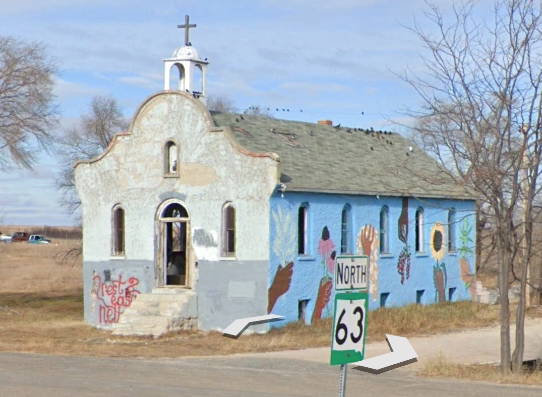
There’s a cool old Catholic Church building in Parmelee. The OD was in the neighborhood, so he took a look:
I found a 2018 Lakota Times article about the mural on the side of the church.
ROSEBUD RESERVATION – An abandoned church in Parmelee, South Dakota now sports a mural on the east wall courtesy of local organizations and businesses.
The St. Agnes Church has stood in the community for as long as local residents can remember. The stucco building was once a hub of activity for members of the Catholic faith. The building was abandoned when a new one was built. A marker on the old church shows it was built in 1927.
Here’s a “before” shot:
A “just beginning” shot:
And a couple of “almost done” shots:
I’ll close with this cool roadway shot posted on GE by “Private Guest” about 12 miles NE of my landing:
I keep track of the watersheds I land in, as well as the town or towns I land near. I do some internet research to hopefully find something of interest about my landing location.
To find out more about A Landing A Day (like who “Dan” is) please see “About Landing” above. To check out some relatively recent changes in how I do things, check out “About Landing (Revisited).”
Landing number 2658; A Landing A Day blog post number 1104
Dan: Today’s lat/long (N33o 18.182’, W110o 44.867) puts me in central-southeast Arizona:
Here’s my local landing map:
My streams-only map showed that I landed very near (and in the watershed of) the North Fork of the Little Humboldt River (1st hit ever!). The North and South folks join up, but Street Atlas leaves us in the lurch!
I went over to Google Earth (GE), to confirm that the Little Humboldt flows between the North & South Fork confluence and the Humboldt. Indeed it does, so, I added the Little Humboldt (3rd hit) to the map:
This is my 31st hit for the Humboldt River watershed, The river ends up in Humboldt Lake, and goes no further. . .
My landing is so out in the boonies that the Orange Dude could not get a look at my landing or any of my local watershed streams. As a consolation, here’s an oblique GE shot looking up the North Fork of the Little Humboldt towards my landing:
The OD had to travel 60 miles south to Winnemucca to get this lovely look of the Humboldt:
So. I landed near McDermitt in August of 2013. I’ll borrow from that post:
From Wiki:
McDermitt straddles the Nevada–Oregon border. McDermitt’s economy has historically been based on mining, ranching and farming, although the last mining operation closed in 1990, resulting in a steady decline in population.
Mining in the area has included gold, uranium, silver and, most notably, mercury. In fact, from 1939 until 1989, this area was the leading producer of mercury in the United States. Here’s a picture of the mercury mineral kleinite (yellow) on calcite (white), from the Cordero mine near McDermitt
Back to Wiki:
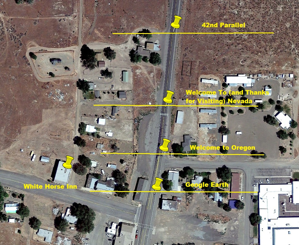
The state line goes through the White Horse Inn, a historical landmark now being restored, which was a saloon, hotel, and (reportedly) brothel. When it was open, food could be ordered and paid for in Oregon, avoiding the Nevada state sales tax.
The community, originally called Dugout, was named after Fort McDermit, which in turn was named after Lt. Col. Charles McDermit. It is not known why there is an extra “t” in the town’s name.
Here’s ALAD’s take on the extra “t:” One of the most powerful and persuasive members on the town-naming committee absolutely never cursed, and strongly frowned on the practice. He thought that “Dermit” was too close to “damn it.” Adding the extra “t” added a little extra distance between the town and the curse . . .
I found this back-in-the-day shot of McDermitt (from Trip Advisor), which shows the town just before a July 4th horse race, circa 1930):
Back to now. I thought that I’d take a closer look at the state line that passes through McDermitt. Back when the state line was first being surveyed, the surveyors were tasked with laying out a line along the 42nd parallel. Here’s a GE shot showing that there appears to be some uncertainty regarding the exact location of the state line:
The OD helped me with the above shot, as he identified the Welcome to Oregon sign:
And the Welcome to Nevada sign:
I figure if anyone knows where the state line is, it would be the state highway departments working on the roads. Note the differences in the roadway on either side of the Welcome to Oregon sign (at the yellow pushpin):
Moving right along . . . I found an article on DonnaBevanLee.com, written by (guess who) Donna Bevan-Lee, a psychotherapist. The article is entitled “Mornings at the White Horse Inn: A Story of Parentification.” Here’s the opening portion of the piece:
When I was six years old, my mother took to her bed. I don’t know how long she stayed there, because time is elastic to a child, but my best guess is several months. My family was living in the tiny western town of McDermitt, which straddles the border between Nevada and Oregon, about halfway from Reno to Boise as the crow flies.
[Wow. Pay attention! Here comes some excellent geology – from a psychotherapist no less!]
The area is high desert, part of a caldera formed sixteen million years ago by the Yellowstone Hotspot, which filled it with valuable ores, especially cinnabar, a source of mercury. My father had landed a good job mining that ore at the open-pit McDermitt Mine leaving the family in a small travel trailer near the handful of buildings that passed for the town of McDermitt.
When I say the trailer was small I don’t exaggerate. It had an eight-foot-square seating area, a tiny kitchen, one low bunk, and a bathroom. At night, my parents shared the bunk, while my siblings and I slept two to wide shelves in the back of the trailer. I liked our cramped sleeping arrangements. With my brother beside me on our shared shelf, I was safer at night than I had ever been–a story for another time.
My mother, however, was miserable. Used to living in a spacious house on her parents’ farm, she hated the small, isolated trailer. Though my father made good money at the mine, he worked very long hours, including Sundays, leaving her with four young children and no family support. One by one, she stopped doing necessary tasks until, finally, she stopped getting up in the morning.
One by one, I took over those jobs. Every morning, after my father left at dawn for his long drive to the McDermitt Mine, I roused my siblings from their shelves, dressed them, and poured their cereal and milk. When everyone had finished eating, I washed the dishes before beginning my most important job of the day: helping my mother get well. Though only six, I knew what to do; I had seen my mother do it many times. I lined up my siblings in the order of our ages beside my mother’s low bunk. As she wept, we all knelt with our elbows on the bed and our hands folded.
“Heavenly Father,” I began, “please help Mommy get better.” I explained that she was sick and recalled that she had prayed for us when we were sick, but mainly I pleaded with God to heal my mother while my siblings knelt quietly waiting for their cue.
“In the name of Jesus Christ,” I prompted, and we all said “Amen” in unison, even the youngest, still in diapers. If I conducted the prayers correctly, I thought, God would heal my ailing mother, so I orchestrated what I hoped were the most perfect, heartfelt prayers four children ever aimed heavenward.
Unfortunately, our efforts were in vain. The straighter we knelt, the more neatly we folded our hands, the more fervently we prayed, the harder my mother sobbed. In other words, my best efforts weren’t just fruitless; they made her worse.
After this daily failure, I took my siblings out of the trailer to give my mother some peace. We played with pop guns and threw rocks in the front yard for a while. Sometimes we found a dead animal and poked it with a stick.
Around mid-morning, all holding hands, we crossed the highway to the White Horse Inn, a two-story cube of red-and-white painted cinderblock fronted by a cement porch with a crooked red roof. We climbed onto barstools and drank root beer in the company of men drinking regular beer, most of them Paiute and Shoshone from the Fort McDermitt Reservation. The beer-drinkers liked us, and I suppose we were cute with our white-blonde hair and our little legs dangling from our barstools. We didn’t know that we were supposed to pay for our root beer, but no one ever mentioned money, just gave each of us a frosty bottle, joked with us, and watched out for us.
Just before lunch, my mother arrived, her face pale, her eyes red-rimmed.
“I’ve been looking all over for you kids,” she said wearily–always the same line, which puzzled me because my siblings and I followed exactly the same routine every day and could always be found at the White Horse Inn. When she arrived, we sucked down the remains of our root beers and meekly followed her back to the trailer, where I helped her make peanut butter and jelly sandwiches for lunch.
The piece goes on with more of the above story, and then discussion of “parentization” and the pros and cons for children who take on a parental role. Click HERE to access the piece.
With thanks to Ms. Bevant-Lee for introducing some geology to this post, I’ll add some more. It turns out that the mineral-rich Yellowstone hotspot caldera (known as the McDermitt caldera) is rich in lithium as well as mercury and other metals. Here’s a video entitled “The Most Valuable Plot of Land in America” by Morning Brew, all about the getting-more-valuable-all-the-time-thanks-to-batteries lithium deposits near my landing:
I’ll close with a couple of pictures posted on GE near my landing. First this, from a few miles south of my landing in the Santa Rosa Mountains, posted by Charles Cannon:
And then this by Michael Jiroch, taken just north of McDermitt:
I keep track of the watersheds I land in, as well as the town or towns I land near. I do some internet research to hopefully find something of interest about my landing location.
To find out more about A Landing A Day (like who “Dan” is) please see “About Landing” above. To check out some relatively recent changes in how I do things, check out “About Landing (Revisited).”
Landing number 2658; A Landing A Day blog post number 1104
Dan: Today’s lat/long (N33o 18.182’, W110o 44.867) puts me in central-southeast Arizona:
Here’s my local landing map:
You can see Globe, just north of my landing. Even though it’s the largest town around, it mysteriously didn’t show up on the above Street Atlas map (so I added it). I’ll switch over to Google Earth (GE) where the Orange Dude could get remarkably close to my landing:
He can see my landing location as well as the valley that carries my runoff:
The OD went several miles to the northeast where he found a spot to check out my drainage further downstream:
And here’s what he sees:
I’ll switch over to a streams-only Street Atlas map (with Gilson Wash added by yours truly):
GE let me know that I landed in the watershed of Gilson Wash; on to the San Carlos River (1st hit ever!); on to the Gila River (49th hit); to the Colorado (201st hit).
Look back up at my local landing map. See all of those towns? Every one of them (except Peridot and San Carlos) was founded as a mining town. Mainly silver and copper, mining has thrived since the late 1800s. (San Carlos is the administrative seat of the San Carlos Apache Indian reservation,, and Peridot is also on the reservation.)
I’ll start with a town that was entirely wiped off the face of the earth – Ray. Here’s a back-in-the-day shot of Ray (from the Arizona Memory Project):
Here’s the Ray School:
And Ray in the early 1950s:
From Wiki, here’s a recent shot:
Note that you can see mine workings in the foreground, where Ray should be. When I typed “Ray” in GE, here’s what came up:
Hmmm. Note that Teapot Mountain is the peak shown on the two earlier photos.
Ray was a company town built by Arizona Hercules Copper company in 1909. Through the 1940s, the mining was underground, but then the operation changed to open pit. And poor old Ray was in the way. All of the Ray residents (and a couple of other small towns) were moved to Kearny, built from scratch in the 1950s. Here’s a GE look at Kearny:
Here are a couple of quick-hitters:
From WorldPopulationReview.com, this about Cutter:
Cutter is a city located in Gila County Arizona. Cutter has a 2024 population of 0. Cutter is currently declining at a rate of 0% annually and its population has decreased by __ since the most recent census, which recorded a population of 0 in 2020.
Christmas was so nameda because the nearby mine was staked out and claimed on Christmas day, 1902.
From Winkelman’s website:
Globe was so named because a large spherical (globe-like) silver nugget was found nearby.
Kelvin was named after Kelvin Grove, a park and a neighborhood in Glasgow Scotland. Here’s a picture of the Kelvingrove bandstand and ampitheater (from WhatsOnGlasgow.co.uk):
Peridot is named after a semi-precious gemstone (the August birthstone) found nearby. Here are a couple of pictures of the mineral. First, an uncut specimen:
Hayden is on its way to becoming a ghost town, primarily (according to Wiki) because of widespread contamination from the copper smelter around which the town was built. Here’s a GE shot of the town:
The OD stopped by to get a look at the huge spoil pile just outside of town:
Miami & Globe are next to each other and next to huge copper mine workings:
Miami is the hometown of Manuel Mendoza, a World War II recipient of the Medal of Honor. Here’s the citation. It’s really gruesome, but speaks to the reality of warfare:
For conspicuous gallantry and intrepidity at the risk of his life above and beyond the call of duty:
Staff Sergeant Manuel V. Mendoza distinguished himself by acts of gallantry and intrepidity above and beyond the call of duty while serving as a Platoon Sergeant with Company B, 350th Infantry, 88th Infantry Division during combat operations against the German army on Mt. Battaglia, Italy on October 4, 1944.
That afternoon, the enemy launched a violent counterattack preceded by a heavy mortar barrage. Staff Sergeant Mendoza, already wounded in the arm and leg, grabbed a Thompson sub-machine gun and ran to the crest of the hill where he saw approximately 200 enemy troops charging up the slopes employing flame-throwers, machine pistols, rifles, and hand grenades.
Staff Sergeant Mendoza immediately began to engage the enemy, firing five clips and killing ten enemy soldiers. After exhausting his ammunition, he picked up a carbine and emptied its magazine at the enemy. By this time, an enemy soldier with a flame-thrower had almost reached the crest, but was quickly eliminated as Staff Sergeant Mendoza drew his pistol and fired.
Seeing that the enemy force continued to advance, Staff Sergeant Mendoza jumped into a machine gun emplacement that had just been abandoned and opened fire. Unable to engage the entire enemy force from his location, he picked up the machinegun and moved forward, firing from his hip and spraying a withering hail of bullets into the oncoming enemy, causing them to break into confusion.
He then set the machine gun on the ground and continued to fire until the gun jammed. Without hesitating, Staff Sergeant Mendoza began throwing hand grenades at the enemy, causing them to flee.
Staff Sergeant Mendoza’s gallant stand resulted in thirty German soldiers killed and the successful defense of the hill. His extraordinary heroism and selflessness above and beyond the call of duty are in keeping with the highest traditions of military service and reflect great credit upon himself, his unit and the United States Army.
Phew.
From Wiki, about Superior:
Like nearby Globe, Ray, and Clifton, Arizona, Superior was once part of a huge Apache reservation, but after silver and copper deposits were discovered, those areas were withdrawn from the reservation and returned to the public domain.
[Sounds familiar.]
In 1872, at the height of the American Indian Wars, a band of raiding Apache horsemen were ambushed by a United States Cavalry force from Picket Post Mountain. After losing 50 men, the Apache retreated up the mountain later named “Apache Leap”. According to local legend, the remaining Apache accepted defeat and leapt to their death rather than being captured by the cavalry, thus giving the mountain its name.
Here’s a GE shot of Superior and vicinity:
And a Wiki shot of Apache Leap:
A couple of mining companies are attempting to develop a huge underground copper mine east and south of Superior, known as the “Resolution Copper” project. Over a billion dollars have been spent by the mining companies, but the project faces huge hurdles, especially considering that the land above the mine is known as “Oak Flat,” a large federally-protected area considered sacred to the Apaches.
I’ll close with some Oak Flat pictures posted on GE. First this one, by Galen Beck:
And then three by Art Brown, beginning with this eerily-human-looking rock:
I keep track of the watersheds I land in, as well as the town or towns I land near. I do some internet research to hopefully find something of interest about my landing location.
To find out more about A Landing A Day (like who “Dan” is) please see “About Landing” above. To check out some relatively recent changes in how I do things, check out “About Landing (Revisited).”
Landing number 2657; A Landing A Day blog post number 1103
Dan: Today’s lat/long (N42o 3.260’, W79o 21.645) puts me in far western New York:
And my local landing map:
My watershed analysis is unique amongst all of my landings – and not because of any stream or river names. I’ll start with my local streams-only map:
I landed in the watershed of Cooper Creek; on to Chautauqua Lake. Chautauqua Lake is drained by the Chadakoin River. So far, so good, but why didn’t I put the number of hits for the Chadakoin River, or say “First Hit Ever!” Let me continue.
The Chadakoin River discharges to the Cassadaga Creek. Say what! A river discharges to a creek? In my thousands of landings, I’ve never had that happen. Note that I didn’t say “I don’t recall this ever happening.” That’s because I’m sure it has never happened.
And it gets worse. Cassadaga Creek discharges to yet another creek – Conewango Creek! Let me zoom back:
The Conewango Creek discharges into the Allegheny River (9th hit); on to the Ohio River (163rd hit); on to the MM (1034th hit).
So one obvious question pops out: should my landing spreadsheet recognize the Chadakoin River as a river? Well, there are three reasons that I decided to break what used to be a cardinal rule: if a waterway is called a river, I treat it as a river. The first reason is that it’s only 7 miles long, the second reason is that it discharges to a creek (which in turn discharges to another creek).
The third reason is related to the second: If I add the Chadakoin as a river, I would be forced to elevate both the Cassadaga Creek and Conewango Creek to river status in the watershed portion of my spreadsheet.
So I decided that my spreadsheet will treat the Chadakoin as if it were a lowly creek.
And now, for a second item: I’ve decided to elevate the “lowly” Conewango Creek to the status of a river! (Sorry, Cassadaga Creek, I’m leaving you out.) It’s 10x longer than the Chadakoin “River” and has a large watershed (900 square miles) that includes Lake Chautauqua.
And get this: Wiki lets us know that the Conewango Creek was named Pennsylvania’s “River of the Year” for 2015.
OK. So here’s a small portion of my spreadsheet, showing the Conewango Creek proudly taking its place amongst ALAD rivers:
Before moving on to Google Earth (GE), here’s a streams-only map showing the nearby continental divide:
As you might suspect (if you thought about it), American Indians had a portage trail to get their canoes over the divide. From PanamaRocks.com (more about Panama Rocks later in the post):
Early French explorers learned of a portage trail from Lake Erie to Lake Chautauqua. This portage connected the Great Lakes with the Allegheny-Ohio-Mississippi River System. This was an important route connecting the eastern and central parts of the continent.
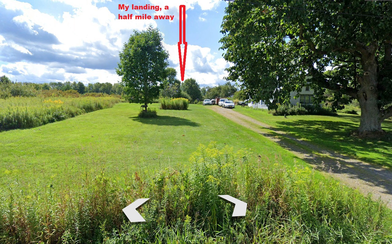
Moving over to GE. The Orange Dude could get about a half mile from my landing:
And here’s what he sees:
He headed north to get a look at Cooper Creek before it discharges into Lake Chatauqua:
Hmmm. I think I’ll zoom in on the sign:
Ashville General Store is quite the local institution. But what’s that creature at the top of the sign? Well, it turns out it’s (he’s?) “Fingerhead,” and the store’s Facebook page was hosting a Fingerhead selfie contest. Here’s one of the entries:
Whatever . . .
I’ve never landed near Lake Chautauqua, but it turns out that I have featured Chautauqua previously on ALAD – in my March 2013 Gladstone Oregon post. Gladstone Oregon – say what? It turns out that I landed near “Chautauqua Lake”, a very small lake in Gladstone Park.
From that post:
Anyway, checking out the “history” section of the City’s website, it turns out that the founder of the City of Gladstone (one Harvey Edward Cross) was heavily involved in the nationwide fad known as the Chautauqua movement (more about that in a minute), and in 1894 he granted a 50-year lease of substantial acreage around a small lake to the Willamette Valley Chautauqua Association for its annual summer assemblies. The property became known as Chautauqua Park and the lake was named Chautauqua Lake.
So, what is Chautauqua? Here’s some background, which I’ve gleaned from Chautauqua.com (the website for the Colorado Chautauqua Association).
The Chautauqua movement started at Chautauqua Lake, New York back in the 1870s. Chautauqua is way out in western NY, not far from Erie PA. Anyway, there was a Methodist church camp there that begin holding a wide range of adult education lectures and seminars, that came to be organized as the Chautauqua Institution. The whole idea caught on, and began to include cultural as well as educational events. It became non-denominational (mildly Protestant), and nation-wide.
Here’s some material from the Chautauqua website:
Before radio and television, the Chautauqua Movement united millions in common cultural and educational experiences. Orators, performers, and educators traveled a national Chautauqua circuit of more than 12,000 sites bringing lectures, performances, concerts, classes, and exhibitions to thousands of people in small towns and cities. Theodore Roosevelt called Chautauquas, “the most American thing in America.”
As its members and graduates spread the Chautauqua idea, many towns—especially in rural areas where opportunities for secondary education were limited—established “chautauquas.” “Chautauqua” had a degree of cachet and became short hand for an organized gathering intended to introduce people to the great ideas, new ideas, and issues of public concern. “Independent chautauquas,” those with permanent buildings and staff could be found throughout the US by 1900, with a concentration in the mid-West.
The movement pretty much died out by the mid-1930s. Most historians cite the rise of the car culture, radio, and movies as the causes.
However, Chautauqua lives on – where else – in its origin city, Chautauqua NY. It’s a big deal, attracting more than 100,000 visitors annually to Chautauqua every summer for a series of lectures, concerts, and other events.
Chautauqua was in the news a couple of years ago, when Salmon Rushdie was attacked by a knife-bearing hater, just as he was about to present a lecture.
From Wiki:
On August 12, 2022, novelist Salman Rushdie was stabbed multiple times as he was about to give a public lecture at the Chautauqua Institution in Chautauqua, New York. A 24-year-old suspect, Hadi Matar, was arrested directly and charged the following day with assault and attempted murder. Rushdie was gravely wounded and hospitalized.
Rushdie, an Indian-born British-American, has been threatened with death since 1989, a year after the publication of his novel The Satanic Verses, when the Iranian Supreme Leader Ayatollah Khomeini issued a fatwa calling for his assassination and set a bounty of $3 million for his death. For years, Rushdie had lived in hiding, taking strict security measures that gradually became more relaxed over time.
In July 1991, the book’s Italian translator Ettore Capriolo was stabbed multiple times at his home in Milan. Ten days later, Hitoshi Igarashi, who translated The Satanic Verses in Japanese, was stabbed to death in July 1991.
Rushdie’s memoir about the attack, Knife: Meditations After an Attempted Murder, is scheduled for publication in April 2024. From Amazon:
From internationally renowned writer and Booker Prize winner Salman Rushdie, a searing, deeply personal account of enduring—and surviving—an attempt on his life thirty years after the fatwa that was ordered against him
Speaking out for the first time, and in unforgettable detail about the traumatic events of August 12, 2022, Salman Rushdie answers violence with art, and reminds us of the power of words to make sense of the unthinkable.
Moving on to Panama. The town is named after the nearby “Panama Rocks,” which is a very cool bedrock outcropping (now a private park) near the town. From the Panama Rocks website:
The traditional story of how Panama got its name is about “Panama Joe,” a man who had been across the Isthmus of Panama, and said these rocks reminded him of rocks there. Eventually, the rocks became known as Panama Rocks.
It is possible that the person known as Panama Joe (aka Moses Marsh), who operated a trading company in Panama and was Panama’s first postmaster. He had previously had a business in the nation of Cuba and traveled across the Isthmus of Panama.
When the village was to be named, Panama Joe (the postmaster) suggested that they name it after him and his famous rocks.
From the website Only In Your State (in the post entitled “The Undwerrated Wonder Every New Yorker Should See at least Once”), I’m going to close this post with shots of Panama Rocks:
I love it when a photographer sees an opportunity for a great picture, and has the patience & skill to make it so . . .
I keep track of the watersheds I land in, as well as the town or towns I land near. I do some internet research to hopefully find something of interest about my landing location.
To find out more about A Landing A Day (like who “Dan” is) please see “About Landing” above. To check out some relatively recent changes in how I do things, check out “About Landing (Revisited).”
Landing number 2656; A Landing A Day blog post number 1102
Dan: Today’s lat/long (N29o 53.555’, W102o 15.746) puts me southwest Texas, east of Big Bend:
Interesting factoid: This was my second straight landing with “746” after the decimal point in my landing latitude. OK so maybe it’s not so interesting . . .
Here’s my very local landing map:
OK, I’ll back out a little:
Oh, al right. I’ll back out a little further:
Phew. We finally can see some towns – although the closest, Dryden is a ghost town, population “about 13.”
Of course, I had to go to Google Earth (GE) to get a look at my local watershed situation:
The Orange Dude hates it when he can’t get a look at my landing, or any of my watershed streams. OK, he can see the Rio Grade, but the nearest spots with Street View where the OD could get a look at the river were 42 miles downstream (with this lousy view):
And 64 miles upstream – with this much better view (and the OD actually in Mexico):
And near the above location (in Mexico), is this walk-in Street View shot:
Hmmm. Looks like a really easy spot to cross over from Mexico. And just who are those folks in the boat?
So, I really wanted to learn if my watershed wash leading to the Rio Grande had a name. Nothing on Google Earth, but of course I had to check out the USGS map. It was tricky figuring out which made had the confluence of the wash with the Rio Grande, but I finaly figured out it was the “Panther Gulch East” map. And no, my wash was no Panther Gulch. Anyway, here’s’ a close-up:
Hmmm. Nothing about my wash. But, I landed near the “Paso Colorado Crossing.” Definitely worth a Google search; but first, this GE look at the crossing:
My Google search revealed an article from News West 9 (Midland TX) entitled “Border Patro – Fighting the Unseen Enemy.” Of course, the Paso Colorado Crossing is mentioned. Here are some excerpts:
SANDERSON – NewsWest 9 followed along as Big Bend Border Patrol Agents were searching Agua Verde, a rough remote region located more than a dozen miles south from the town of Dryden. This time agents are searching for a group who crossed the Rio Grande in the late night hours.
“They’re resting because they walked all night. Got a full moon, so it’s almost like daylight out here at night when we got a full moon. So they can see and navigate and walk. They’ll walk at night because it’s an advantage to them and a disadvantage to us,” Big Bend Sector Public Officer, Rush Carter, said.
Carter along with other agents are trying to incept them. Tracking them footprint by footprint.
“Have to be real careful when we’re cutting here and take our time and look for those kicked over rocks, hopefully a foot print. Something to give us a clue that someone passed through this area,” Carter said.
Border Patrol Agents were able to locate the group deep inside the canyon, they say they crossed near the Paso Colorado crossing in Terrell County. Nine out of the ten Mexican nationals that they were looking for were arrested and processed for removal.
“They convey that they’re trying to get here to better their lives. But what I convey to them is that we’re out here doing our job to secure the border and when we apprehend people like that, it’s just our job and what we’ve been tasked with,” Carter said.
I also found “Paso Colorado Crossing” in this 1918 book:
The reference to the crossing wasn’t in the geology part of the book; rather the “roads” part of the book. As you’ll see, they also reference a nearby location known as “Bone Watering.” I encourage you to actually read the following:
Note that it says, “The break in the cliffs of the river is so narrow that it is necessary to lead horses down to the water one at a time.”
The write-up goes on:
If you’re a long-time reader of this blog, you’ll know that I dutifully searched for more information about Bone Watering, with my main objective being a map. I spent an inordinate amount of time performing said search, but to no avail. Based on the clues in the write-up, I knew it couldn’t be far from my landing . . .
OK, OK. I found a Rio Grande water quality monitoring station called “Upper Bone Watering.” Here’s a map:
Well, lookee there! It’s right at the Paso Colorado Crossing! However, based on the road descriptions, they actually can’t be the same location. And for the record: I Googled “Middle Bone Watering” and “Lower Bone Watering,” to no avail.
Most people investigating Bone Watering would let it go (and wouldn’t have gone as far as I did). But I’m me, and I felt compelled to at least speculate on Bone Watering’s location. Based on the write-up, I know that it’s west of Paso Colorado Crossing, and I believe that it wouldn’t be outside the big meander that contains the Crossing. It’s a break in the cliff that contains a narrow trail down to the river (wide enough or only one horse at a time). So. Here’s my best shot:
And here’s a close-up of my proposed Bone Watering location:
The more I think about it, the more confident I am that I found it. Case closed!
It’s time for a quick visit to Dryden. It’s a railroad town, and its population maxed out at something above 100 back in the 1920s. It had a hotel, a saloon and a school. It probably had a church (didn’t all ghost towns with a hotel, school and saloon also have a church?), but nothing was said about a church. It’s current population is said to 13.
From Texas Escapes, here’s a picture of the Purple Sage Saloon:
And the school:
I’ll close with this shot of the Rio Grande a few miles upstream, posted on GE by Greg Anderson:
I keep track of the watersheds I land in, as well as the town or towns I land near. I do some internet research to hopefully find something of interest about my landing location.
To find out more about A Landing A Day (like who “Dan” is) please see “About Landing” above. To check out some relatively recent changes in how I do things, check out “About Landing (Revisited).”
Landing number 2655; A Landing A Day blog post number 1101
Dan: Today’s lat/long (N41o 59.380’, W97o 1.746) puts me in northeast Nebraska:
Here’s my local landing map:
You can see on the above map that I landed adjacent to the Elkhorn River (4th hit). Here’s my streams-only map:
The Elkhorn is part of the Platte River watershed (78th hit); on to the Missouri (470th hit); on to the MM (1033rd hit).
The Orange Dude headed to the bridge over the Elkhorn just south of Pilger:
Here’s his upstream (west) view:
He went a few hundred yards south, to a minor crossroads, where he looked east towards my landingm which is situated about a mile and a half down the dirt road:
Here’s where I landed:
The OD and I were totally bummed out that there is no Street View covereage here.
So. Look at all of those towns on my local landing map. I checked them all. EACH AND EVERY ONE. I could find no hook significant enough to carry the day. And these aren’t all teeny towns. Nearly all have a fairly substantial system of streets and cross streets (except for Enola).
So anyway, I thought I’d do a grand tour, saying something about each one (after dutifully letting you know the population of each).
I’m going to start with the far-and-away largest town, Norfolk (pop 24,200), which is the hometown of Johnny Carson.
I enjoyed watching Carson off and on throughout most of his career and I just finished a You Tube tour of Johnny’s greatest moments (which, for the most part, were hilarious).
Stanton (pop 1600) was named after Edwin Stanton. Hmmm. Edwin Stanton is a familiar name, but if you’re like me, you can’t put your finger on his identity. Well, he was Abraham Lincoln’s Secretary of War. From Wiki:
Edwin Stanton (1814 – 1869) was an American lawyer and politician who served as Secretary of War under the Lincoln Administration during most of the American Civil War. Stanton’s management helped organize the massive military resources of the North and guide the Union to victory.
However, he was criticized by many Union generals, who perceived him as overcautious and micromanaging. He also organized the manhunt for Abraham Lincoln’s assassin, John Wilkes Booth.
Pilger (pop 350; closest to my landing) was hit by devasting twin tornados on June 16, 2014:
The tornados caused two deaths and 20 injuries.
Wisner (pop 1170) is the hometown of Private Dale Hansen, a Medal of Honor winner for his actions on Okinawa during WW II. Here’s a portion of his citation:
Cool and courageous in combat, Marine Private Hansen unhesitatingly took the initiative during a critical stage of the action and, armed with a rocket launcher, crawled to an exposed position where he attacked and destroyed a strategically located hostile pillbox. With his weapon subsequently destroyed by enemy fire, he seized a rifle and continued his one-man assault.
Reaching the crest of a ridge, he opened fire on six Japanese and killed four before his rifle jammed. Attacked by the remaining two Japanese, he beat them off with the butt of his rifle and then climbed back to cover.
Promptly returning with another weapon and a supply of grenades, he fearlessly advanced, destroyed a strong mortar position and annihilated eight more of the enemy.
In the forefront of battle throughout this bitterly waged engagement, Private Hansen, by his indomitable determination, bold tactics and complete disregard of all personal danger, contributed greaty to the success of his company’s mission and to the ultimate capture of this fiercely defended outpost of the Japanese Empire.
Private Hansen was killed by Japanese sniper fire three days later . . .
Beemer (pop 680) was named after the German automaker* and is the hometown of sports and political cartoonist Karl Hubenthal. Here’s a Vietnam-era Hubenthal cartoon (combing sports and current events) showing how North Vietnam’s guerilla tactics were hard to deal with:
* Just kidding . . .
West Point (pop 3,500) was not named after the famous New York state military academy. It started out as New Philadelphia (yes, named for the reason you’d think), but was called West Point because (according to Wiki) it was the “westernmost outpost along the valley.” It’s the oldest town in the area, so I guess that makes sense.
Scribner (pop 860) has a familiar ring to it, and in fact it was named after publisher Charles Scribner, founder of the publishing house that eventually became Charles Scribner’s Sons.
Born in New York City and a graduate of Princeton, I have no clue as to why a small town in Nebraska is named after an east coast publisher . . . .
Snyder (pop 300) was named after Conrad Schneider, the original owner of the town site. I would guess that “Schneider” sounded a little too German for the locals who likely changed the name during WW I (although I could find nothing on the internet about the name change).
Speaking of finding nothing, I could find nothing to say about Dodge (pop 620). As happens when this is the case, I typically default to a back-in-the-day (turn of the century) shot of Main St. Here goes:
The town of Howells (pop 560) has a website . . .
. . . that says this about the town’s name:
In 1887, officials of the Fremont Elkhorn and Missouri Valley Railroad designated the name “Howell” to the community. This name honored James Smith Howell, who was a local surveyor, farmer and teacher. The final “s” was added in 1937 making the legal name Howells.
Oh, come on! Anyone who reads this wants to know WHY the final “s” was added!
Moving on to Clarkson (pop 670) I found this cool 1918 photo from ClarksonHIstory, a WordPress blog with a piece by Glenn Cada entitled “The End of the Good Times?”):
Here’s Glenn’s write-up that follows the photo:
A while back Vickie Obermaier, a descendant of Clarkson’s Kudrna clan, sent me this interesting portrait of a haymaking crew taking a break from their labors. Mugging for the camera, they stand stock-still in their poses (only the blurred horses’ heads betray the long shutter speeds of the old camera). Two of the farmers are holding stoneware crocks of… lemonade? All sorts of little details can be made out from this old photo – steel-wheeled hayracks, fly nets on the draft horse harnesses, some sort of row crop in the background.
Seven wagons bulging with hay, it is a picture of agricultural prosperity – the Promise of the New World. This was a major reason many came to America in the first place – work hard and get rich. There is little doubt that the men were enjoying their brief rest before pushing on to the painstaking (and dusty) task of constructing haystacks. And there is no doubt that they are unaware that the prosperity to which they have been accustomed was about to come to a sudden end. These happy farmers were on the verge of a two-decade long period of hard times.
Hmmm. I know about the Depression & Dust Bowl of the 1930s, but I’m not sure about the hard times beginning in the 20s . . .
Leigh (pop 400) is the hometown of Audrey Stevens Niyogi, a biochemist who is the “co-discoverer of RNA polymerase.”
Wiki has a coo picture of her father with his two daughters at their farm just outside of Leigh. Audrey is on the right and her twin sister Ardyce on the left.
I won’t go into any details on her discovery, but Wiki lets us know she was a brilliant scientist. Strangely (to me, anyway), Wiki also says this:
Audrey was an early pioneer in balancing a scientific career with family life. In 1964, she married fellow biochemist, Salil Kumar Niyogi. They remained married until their deaths in 2010.
After her second son was born in 1967, to devote more time to parenting, Audrey had her position at Oak Ridge National Laboratories officially changed to half time. Although she continued to work hours that were closer to full-time, this gave her the flexibility to be more available to her children.
An interesting Wiki tidbit . . .
According to Wiki, Creston (pop 200) was so named because of its “lofty elevation.” After performing a comprehensive Google Earth survey of elevations in the village and surrounding areas, I unequivocally have this to say: Creston in no way stands out from surrounding areas due to its elevation.
I think that Creston, Nebraska was named after Creston, Iowa (featured just a few posts ago). Creston Iowa is actually appropriately named, as it is located on a major watershed divide.
Humphrey (pop 750) is the hometown of one Max Carl, an accomplished rock-and-roll musician who played with 0.38 Special (1980s) and Grand Funk Railroad (1990s to present).
Madison (pop 2300) is the hometown of writer Artmitage Trail. Yes, that’s his name, although he was born Maurice Coons. From Wiki:
As a teenager in New Orleans, Trail developed a passion for writing, quitting school at the age of 16 to devote his time to it. Likewise, his interest in gangsters such as Al Capone began at a young age, and it was stated by Hannibal Coons that his brother Maurice “was interested in gangsters as other men are interested in postage stamps, old coins, or spread-eagled butterflies.”
Throughout the rest of his teens and early twenties, Maurice Coons used a variety of pseudonyms, writing various crime and detective stories for pulp magazines. During this time, he ended up living in the Chicago area, where he wrote his only well-known work, Scarface, a novel about gangster Al Capone.
Not much is known about Trail’s time in Illinois. He lived in Oak Park, Illinois [Hey! So did I!] a town adjacent to the west side of Chicago, where he worked on composing Scarface daily in his sun-room. He did not live in Oak Park long enough to be recorded by an official U.S. Census.
Trail spent much of his time in Chicago associating with local Sicilian gangs in order to gain ideas for his novel. Trail published Scarface in 1930.
Here’s Wiki’s plot summary for the novel:
The book’s storyline is heavily inspired by the real life gangster Al Capone whose nickname was also “Scarface”. The novel concerns the rise and fall of Tony “Scarface” Guarino, who after performing a hit on mob leader Al Springola, moves in to take over the illegal alcohol business in Chicago during the Prohibition Era. He is ultimately shot dead by his brother, who fails to recognise him due to the family believing that he died in World War I.
[Wow. Strange plot twist. Could that be true about Al Capone? A quick check on Al Capone shows that he died in 1947 at age 47 after a lengthy illness.]
Producer Howard Hughes [yes, that Howard Hughes] eventually approached Trail about his novel with the interest of adapting it as a movie. Trail sold the rights to Scarface to Hughes for $25,000, relocating to Los Angeles in the process.
After selling the rights to Scarface, W.R. Burnett, who worked on the screenplay, stated that Trail began to struggle with alcoholism. Trail lived flamboyantly in Hollywood [burning through his new-found fortune] rapidly gaining weight, wearing wide-brimmed Borsalino hats, and hiring a servant named Elijah Ford.
[Strange Wiki detail, about the hats and his servant . . . ]
Trail never lived to see the movie Scarface finished, and died in October 1930 of heart failure while at the Paramount Theatre.
Phew. I’m ready for my final stop, in Enola. No population was listed in Wiki; I’m sure it’s less than 20. Here’s a GE shot of the town:
Maybe 5 or 6 houses? The only “Enola” I know is the U.S. bomber that dropped the atomic bomb on Hiroshima – the Enola Gay – a name that will live in infamy (sorry, Oppie). It was named after Enola Gay Tibbets, mother of pilot Paul Tibbets.
However, the Nebraska town was named after its founder T. J. Malone. Look at his last name, and you’ll see where the name came from. Just forget about the “M.”
Speaking of the Enola Gay, in a March 2017 post, I featured my Mobil Oil work trip to Tinian Island, where the Enola Gay took off loaded with the A-bomb to be dropped on Hiroshima. I just re-read the portion of my post about Tinian, and it is well worth the read. Just type “Tinian” in the search bar.
I’ll close with this picture of a church that certainly has seen better days. It is posted on GE by Matt Ellenbergern and taken in the middle of nowhere (i.e., about halfway between Pilger and Howells) . . .
I keep track of the watersheds I land in, as well as the town or towns I land near. I do some internet research to hopefully find something of interest about my landing location.
To find out more about A Landing A Day (like who “Dan” is) please see “About Landing” above. To check out some relatively recent changes in how I do things, check out “About Landing (Revisited).”
Landing number 2654; A Landing A Day blog post number 1099
Dan: Today’s lat/long (N39o 9.874’, W89o 27.514) puts me in Central-east Utah:
Here’s my local landing map:
Note that I landed in the watershed of Green River (39th hit). Although not shown, the Green River makes its way to the Colorado River (200th hit).
I’lll go over to Google Earth (GE) for a look at my local watershed:
You can see that I landed in the watershed of Saleratus Wash. How did I find out it was the Saleratus Wash? I had to go to the Green River USGS quadrangle map:
It turns out that “saleratus” is Latin for “aerated salt”, that actually has come to mean sodium bicarbonate, which is actually baking soda. There’s a naturally-occurring mineral, nahcolite, that contains sodium bicarbonate, From Wiki:
Naturally occurring deposits of nahcolite (NaHCO3) are found in the Eocene-age Green River Formation.
There you have it.
The Orange Dude positioned himself to get a look at the unnamed tributary of Saleratus Wash:
And here’s his view:
He then went down to Green River to get this lovely look at (what else?) the Green River:
The OD and I headed east on I-70 and got off at Thompson (aka Thompson Springs).
It turns out that the canyon north of town is the home a an absolutely stunning collection of ancient Native American rock art. Some of the art may be as old as 8000 BC. On our way, the OD jumped out in front of me hoping to get a look at some of the art. Excitedly, he came back to me (while I was still in I-70) to show me this:
Here’s a shot of one of the rock formations with drawings:
Here are some other shots:
I personally commissioned a well-known archeological-restoration artist. She started out with this:
And ended up with this, her conception of what the art looked like soon after its creation:
The artist? My wife, Jody.
And here’s another one:
And Jody’s recreation:
I love these figures! I have no particular insight as to their meaning. Your guess is as good as mine. Mythologic? Hallucinogenic? Aliens?
Here’s a wonderful panel of figures from another Utah site:
And a close-up of the left-hand panel known as the Holy Ghost panel:
Moving right along (so to speak), I’m going to head further east on I-70, and get off the Cisco exit:
It’s amazing that the “town” has an exit sign, since its population has been zero for decades (note it says “NO SERVICES” on the above sign). The town started off as a railroad servicing center; it had a saloon (of course), restaurants, a hotel and stores. Oil and gas was discovered, and the town survived long enough into the 20th century to get its own Zip Code. Here’s a picture of some of what remains from Wiki:
And a couple posted on GE, first this by Andy Dzierzba:
I wonder how many times he has verbally spelled out his last name . . .
And this, by Dakarzen:
I’ll close with this shot posted on GE by Juli McIntosh of the bluff (the Book Cliffs), north of my landing: