First timer? In this formerly once-a-day blog (and now pretty much a once-a-week blog), I use an app that provides a random latitutde and longitude that puts me somewhere in the continental United States (the lower 48). I call this landing.
I keep track of the watersheds I land in, as well as the town or towns I land near. I do some internet research to hopefully find something of interest about my landing location.
To find out more about A Landing A Day (like who “Dan” is) please see “About Landing” above. To check out some relatively recent changes in how I do things, check out “About Landing (Revisited).”
Landing number 2539; A Landing A Day blog post number 984

Dan: Today’s lat/long (N40o 6.472’, W115o 33.482) puts me in central-NE Nevada:

Talk about empty space! Check out my local landing map:

As you might guess from the above map, my watershed analysis is a no-brainer:

You guessed it. Ruby Lake / Ruby Valley is internally-drained. Let’s use an oblique Google Earth (GE) shot to look up Ruby Valley:

And here’s a Wiki shot looking up the valley, taken from just south of my landing:

Speaking of Wiki, they have this to say about the Ruby Valley:
The valley played an important role in the history of the Great Basin. Nomadic tribes of the Shoshone nation used Ruby Valley as a winter home, finding it warmer than nearby locations. The California Trail, active after the 1840s, was located just to the north, although an alternate route known as the Hastings Cutoff (established in 1845) passed through the southern end of the valley and across the Ruby Mountains via the Overland Pass.
Here’s an oblique GE shot of the Overland Pass:

Hastings Cutoff was Wiki-clickable:
The Hastings Cutoff was an alternative route for westward emigrants to travel to California, as proposed by Lansford Hastings in The Emigrant’s Guide to Oregon and California. The ill-fated Donner Party infamously took the route in 1846.

A sentence in Hastings’ guidebook briefly describes the cutoff:
The most direct route, for the California emigrants, would be to leave the Oregon route, about two hundred miles east from Fort Hall [in today’s Idaho]; thence bearing West Southwest, to the Salt Lake; and thence continuing down to the bay of St. Francisco, by the route just described.
Yo, Mr. Hastings! For west-bound travelers (which is the main point of his cutoff trail), it’s terrible to tell them to get off the main trail “two hundred miles east from Fort Hall.” (FYI, Fort Hall is in Idaho.)
In other words, when you get to Fort Hall, you went two hundred miles too far. So turn around, go two hundred miles, and make a right.
So how did Hastings get the word out about his trail? Well in 1846, he positioned himself in Fort Bridger WY, just east of where his trail heads south. (He obviously realized that Fort Hall was irrelevant to his trail.) He wrote an open invitation to west-bound travelers to meet him in Fort Bridger, and gave it to an east-bound traveler, telling him to spread the word to those he met on his way, so they would travel together on his cut-off trail.
About 70 wagons took him up on his offer. According to Wiki:
They endured a difficult descent down Weber Canyon [down to the Salt Lake Valley], a waterless drive of 80 miles across the Great Salt Lake Desert, and a lengthy detour around the Ruby Mountains [and then across the Overland Pass]. Despite the usual trials of overland travel, they arrived safely in California.
More famously, the Donner Party followed the Hastings Cutoff that same year, just behind Hastings’ party. It was Donner’s intent to meet up with Hastings, but they arrived in Fort Bridger about a week late.
After Hastings realized how tough the trail down Weber Canyon was, he wrote up a suggestion for an alternate route down to the Salt Lake Valley, and sent a currier eastbound to let following travelers know. Maybe he heard that the Donner Party was coming, and knew he missed them.
Anyway, word did get to the Donner Party. From Wiki:
The roadbuilding required through the Wasatch Mountains [to avoid Weber Canyon] and the grueling Great Salt Lake Desert delayed them. When they had arrived at the California Trail [after traversing the Overland Pass], they were delayed about a month. The party arrived at Donner Pass just as an early winter storm rendered it impassable. After becoming snowbound in the Sierra Nevada, many died of starvation, and some of the emigrants resorted to eating their animals and the deceased members of the group.
More about the Donner Party in a bit. On to the Overland Pass entry from Wiki:
Overland Pass was also the site of much activity in the 1860s. A trading post and a way station there for a mail and stagecoach line was established in 1860. The Pony Express and its successor, the Transcontinental Telegraph, also ran through Overland Pass.
In 1862 Fort Ruby was established at the east entrance to the pass to protect the passage of settlers on their way California during the war years.
Around 1866, Wells Fargo began to develop agriculture in the Ruby Valley to help support its way stations.
But, in the late 1860s the Transcontinental Railroad was routed well to the north, and Overland Pass fell into disuse. Fort Ruby was closed in September 1869, seven years after it was built.
While the Hastings Cutoff was still active, it was also a portion of the Central Overland Trail (which included the Overland Pass). From Family Search.com, here’s a map:

And a short write-up:
The Central Overland Trail was a shortcut of the California Trail. It was surveyed, improved for stagecoaches, and opened by the U.S. Army in 1859 from Salt Lake City, Utah through central Nevada to Carson City, Nevada, a distance of about 650 miles. This more direct route shaved off 280 miles, about two weeks travel time, from the length of the original California Trail.
The Central Overland Route quickly took an important role in the American economy. Several stage lines could reach California from Missouri in 25 to 28 days of travel day and night using this trail. California gold was often sent east for Union army payrolls via this route. Likewise, the Pony Express coast-to-coast 10-day mail service (1860-1861) and the first transcontinental telegraph line (1861) also followed this route.
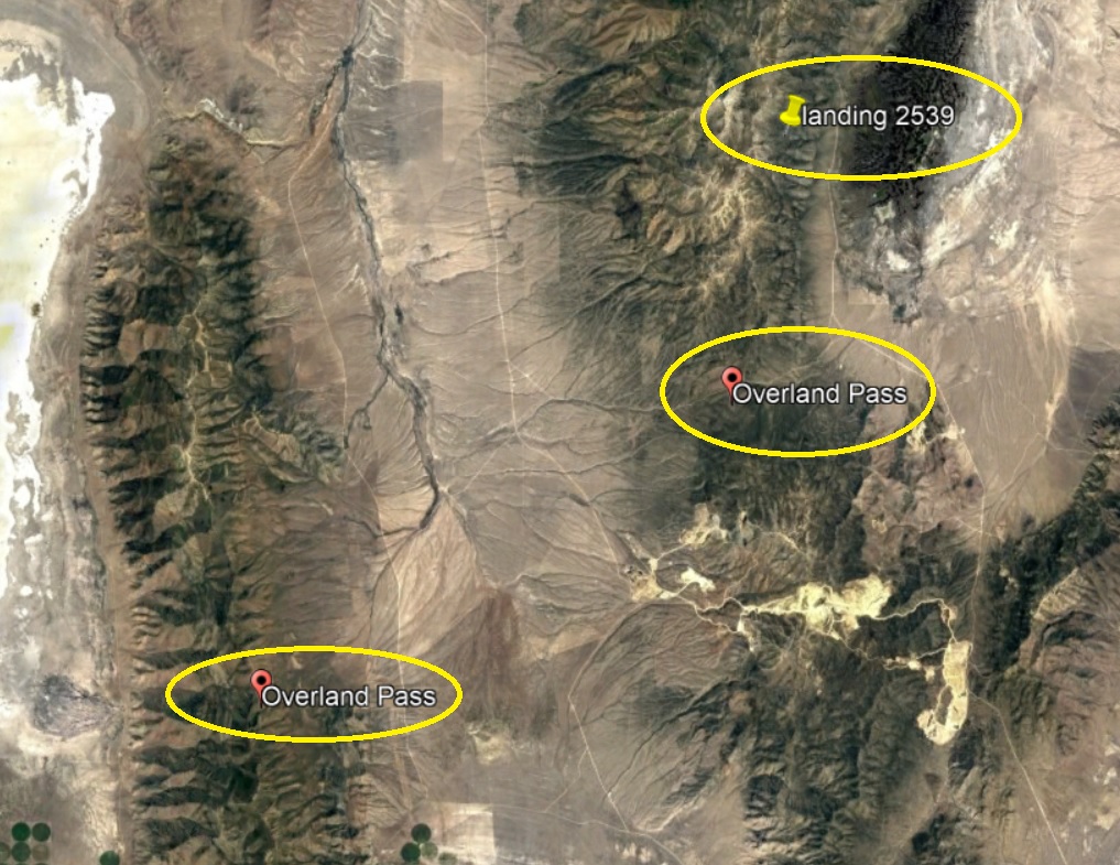
Well, there you have it. I was excited to find a YouTube video of a horseback rider approaching the Overland Pass. But reading the fine print, it turns out there are two “Overland Passes” along the Central Overland Trail, and this one is just west of the one we’ve been talking about. Interestingly, when I typed “Overland Pass” into Google Earth, it knew there were two:
Anyway, here’s the video. It’s very short and worth the watch to get a feel for what it like plodding across the desert on horseback:
As promised, I have some more on the Donner Party, and yes, I featured Donner Pass and the Donner Party in a previous January 2013, Truckee CA post. From that post:
Speaking of Donner Pass, it’s located about 5 miles from my landing. Here’s an oblique GE shot showing Donner Lake in the foreground (which used to be called Truckee Lake, by the way), and Donner Pass in the distance. This is the setting for the Donner party drama discussed a little later in the post. My landing (not shown) is off to the left.

A two-lane road (the old Lincoln Highway) climbs through Donner Pass. FYI, I-80 follows the Old Lincoln Highway for the most part, but climbs over the mountain a little north of Donner Pass (at an elevation more than 100 feet higher than Donner Pass). Here’s a Wiki picture of Donner Pass (looking east), with the caption beneath:

Donner Lake in the distance and the now abandoned railroad grade over Donner Pass. The Lincoln Highway can be seen in the middle of the photo, climbing the pass, on the left side of the photo
This about Donner Pass, from Wiki:
To reach California from the East, pioneer emigrants had to get their wagons over the Sierra. In 1844, the Stephens Party followed the Truckee River up into the mountains. At the head of what is now called Donner Lake, they found a low notch in the mountains and became the first overland emigrants to use the pass.
The pass received its name, however, from another group of California-bound emigrants. In early November 1846, the Donner Party found the route blocked by snow and was forced to spend the winter on the eastern side of the mountains, in cabins near Donner Lake. Of the 81 emigrants, only 45 survived to reach California; some of them resorted to cannibalism to survive.
Also from Wiki (more detail on the Donner Party ordeal):
Both a source of settler pride and an example of hubris, the Donner Party ordeal is Truckee’s most famous historical event. In 1846, a group of settlers from Illinois, originally known as the Donner-Reed Party but now usually referred to as the Donner Party, became snowbound in early fall as a result of several trail mishaps, poor decision-making, and an early onset of winter that year.
Choosing multiple times to take shortcuts to save distance compared to the traditional Oregon Trail, coupled with infighting, a disastrous crossing of the Utah salt flats, and the attempt to use the pass near the Truckee River (now Donner Pass) all caused delays in their journey.
Finally, a massive, early blizzard brought the remaining settlers to a halt at the edge of what is now Donner Lake – about 1,200 feet below the steep granite summit of the Sierra Nevada mountains and 90 miles east of their final destination, Sutter’s Fort near Sacramento.
Several attempts at carting their few remaining wagons, oxen, and supplies – sometimes by pulling them up by rope – over the summit proved impossible due to freezing conditions and a lack of any pre-existing trail. The party returned to their camp near Donner Lake, broken in spirit and short on supplies.
What followed during the course of the brutal winter is a miserable story of starvation, including cannibalism. The survivors were saved by a Reed Party member who had been ejected from the party months earlier (and taken a different trail to Sacramento). Seeing that the Donner Party never arrived at Sutter’s Fort, he initiated several relief parties. Of the original 87 settlers, 48 remarkably survived the ordeal.
Moving right along . . . this, about Donner Pass weather, from Wiki:
Winter weather at Donner Pass can be brutal. At an average of over 34 feet of snow per year, Donner Pass is one of the snowiest places in the United States. Four times since 1880 total snowfall at Donner Summit has exceeded 60 feet and topped 65 feet in both 1938 and 1953.
Wow. A brutal place to winter over with no food in an unheated cabin . . .
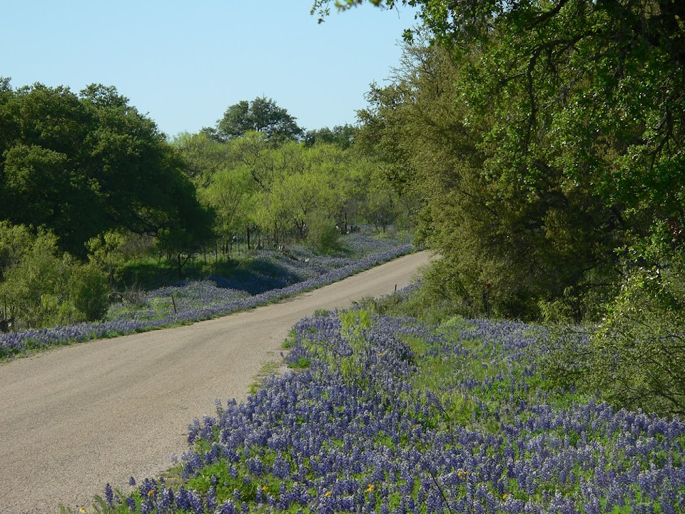
OK. Time to head back to the Ruby Valley, with some wonderful pictures posted on GE, starting with this by DC Carr:

And this, by Don Hall

By Gary Clark:

By Michael Cotton:

And saving the best for last, by our old friend Ralph Maughan:

That’ll do it . . .
KS
Greg
© 2021 A Landing A Day