First timer? In this formerly once-a-day blog (and now pretty much a once-a-week blog) I use an app that provides a random latitude and longitude that puts me somewhere in the continental United States (the lower 48). I call this “landing.”
I keep track of the watersheds I land in, as well as the town or towns I land near. I do some internet research to hopefully find something of interest about my landing location.
To find out more about A Landing A Day (like who “Dan” is) please see “About Landing” above. To check out some relatively recent changes in how I do things, check out “About Landing (Revisited).”
Landing number 2592; A Landing A Day blog post number 1037

Dan: Today’s lat/long (N30o 20.461’, W101o 65.861) puts me more-or-less in southwest Texas:

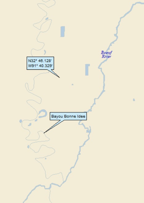
Here’s my local landing map:

To check out my watershed, let’s head over to Google Earth (GE). The Orange Dude found a road over the arroyo that apparently drains my landing location:

And, thanks, to the Texas DOT, the drainageway has a name:

So I landed in the watershed of Big Canyon. Here’s the upstream look:

Why this is called a canyon, let alone a big canyon, is beyond me. Heading quite a few miles south, the OD found another bridge over the same arroyo:

But now it’s called Lozier Canyon. Here’s he upstream view:

Lozier Canyon “discharges” into the Rio Grande (55th hit). Here’s an oblique GE shot showing where the Lozier Canyon and the Rio Grande meet:

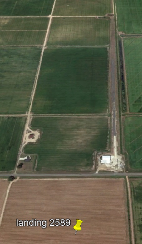
The OD reminded me that he could get a good look at my landing (he’s only 100 yards away):

Not a terribly exciting view:

I noticed that the road next to my landing runs right along a watershed divide (which makes sense, since there will be no drainageway crossings!):

While doing my usual internet perusal of the towns near my landing, I was somewhat discouraged until I looked at Langtry. Wiki let me know that it was in Langtry that Judge Roy Bean resided and practiced law.
“Judge Roy Bean” rang a bell in the back of my head – I seemed to remember writing about the Judge – so I did a quick search of my blog. It turns out that in July 2018, I landed near Ingomar, Montana, the proud home of a restaurant & bar called the Jersey Lilly, named after an establishment of the same name founded by Judge Roy Bean in Langtry TX.
Judge Roy named his establishment after Lilly Langtry, an actress/singer who hailed from Jersey, one of the Channel Islands between England and France. Her nickname as a well-known vaudeville performer (and heart throb) was Jersey Lilly. One could easily jump to the conclusion that Langtry Texas was named after Lilly Langtry, but apparently one would be wrong. It seems that the Texas town was named after a Mr. George Langtry, who worked for the local railroad.
So why did Judge Roy Bean name his establishment after Lilly Langtry? My guess is that since he lived in Langtry, Texas, he became curious about Lilly Langtry, who was rather well known back in the late 1800s. Apparently the Judge often boasted of a relationship with Lilly, but in fact he never met her.
More about the relationship between Judge Roy and Lilly in bit. But first: who exactly was Judge Roy Bean, and why did he become famous?
He was born Phantly Roy Bean in Kentucky in 1830-ish, the youngest of three sons. As the three boys became young men, they headed west. He and his oldest brother went to Mexico, where Phantly managed to get in a fight and shoot a man. He went to San Diego, where he hooked up with his other brother. He was involved in a shoot-out, for which he was arrested. He escaped (and permanently dropped “Phantly” – good idea, I’d say) and ended up in San Gabriel California.
The outbreak of the Civil War prompted Roy to move to San Antonio, and took a young Mexican wife. He fathered 4 children, adopted a fifth, and engaged in shady business practices (heading up an organized crime ring) such that his neighborhood was known as Beanville.
From American Cowboy.com:
The marriage didn’t last and when, in the early 1880s, the Southern Pacific Railroad arrived in West Texas on its mission to complete the Sunset Route from New Orleans to Los Angeles, Bean, leaving [escaping from?] his wife and children, moved west with railroad worker tent camps, offering “services” from his canvas-sided saloon.
As is most often the case with railroad tent cities, law and order were lacking and the Texas Rangers became hard pressed to quell the disruptive behaviors emerging from these train-stop desert towns. In response, for reasons none too obvious, Roy Bean was appointed Justice of the Peace in then-Pecos County on Aug. 2, 1882. Judge Roy declared himself the “Law West of the Pecos.”

From Legends of America.com, here’s an example of Judge Roy’s justice:
Despite the protest of Texas Rangers, Bean thought it preposterous to forbid a man to carry a weapon. Bean released one man who was arrested and accused of carrying a concealed weapon with the following logic.
“That charge won’t stick,” pronounced the judge. “If he was standing still when he was arrested, he wasn’t carrying weapons because he wasn’t going no place. And, if he was not standing still, he was traveling, and it’s legal for travelers to carry weapons. Case dismissed.”
And another from Desert USA.com:
Roy Bean’s justice was not complicated by legalities; it was characterized by greed, prejudice, a little common sense and lots of colorful language. Ruling on a minor disturbing-the-peace offense: “It is the judgment of this court that you are hereby tried and convicted of illegally and unlawfully committing certain grave offenses against the peace and dignity of the State of Texas, particularly in my bailiwick,” was a typical Bean ruling. “I fine you two dollars; then get the hell out of here and never show yourself in this court again. That’s my rulin’.”
More from Desert USA:
In 1898, prizefighting had become illegal in most Western states, as it was in Mexico, and promoters could find nowhere to hold the world championship title bout between Bob Fitzsimmons and Peter Maher. On February 22, the Jersey Lilly was packed with 200 fight fans who, after a few rounds of drinks, followed Roy to a bridge he built to a sand bar in the Rio Grande River [and technically in neither Texas nor Mexico].
While law enforcement (the Texas Rangers) watched the makeshift ring helplessly from atop the bluff, Fitzsimmons decked Maher in only 95 seconds. After returning to the saloon for more drinks, the fans and sportswriters headed for El Paso, where news stories were filed to papers throughout the U.S.
This event launched the birth of the Roy Bean legend, which burgeoned after continued newspaper and dime novel accounts of his exploits, many fabricated by Roy himself. The myth of Roy Bean eventually became part of Texas folklore.

For years, Roy boasted of his “acquaintance with Miss Langtry,” and promised locals she would one day arrive and sing in Langtry. In 1896, after his first saloon was destroyed by fire, Roy rebuilt the Jersey Lilly and constructed a home for himself across the street, which he called the Opera House, anticipating the day when Lillie would perform there.
Roy never met Miss Lillie, but he often wrote her, and she is purported to have written back, even sending him 2 pistols, which he cherished till his dying day. He told Lillie that he named the town after her.
Almost a year after his death, Lillie Langtry finally visited his old home. En route from New Orleans to Los Angeles, she stopped to listen to the townspeople tell the stories of Judge Roy Bean. Of the visit, she would later write, “It was a short visit, but, an unforgettable one.”
Contrary to the Larry McMurtry novel and movie Streets Of Laredo, Roy was not gunned down by a Mexican outlaw on the steps of the Jersey Lilly. In March 1903, Roy went on a drinking binge in Del Rio and simply died peacefully in his bed the following morning.
Today, the Jersey Lilly Saloon still stands in Langtry, Texas, along with his home and a museum.
Here’s a back-in-the-the day shot of the Jersey Lilly:

And today (from the Austin Chronicle):

Here’s Judge Roy and underlings in front of the Jersey Lilly:

There was a 1972 movie entitled “The Life and Times of Judge Roy Bean,” starring Paul Newman.

It received decidedly mixed reviews. Here’s a shot from the film:

Getting ready to close things down, here’s a shot posted on GE by Maukin-The-Wise, showing Mexican cliffs along the Rio Grande near Langtry:

And another, of the Rio Grande downstream from Langtry posted by shummla 7:

No wall is needed along this stretch of the border!
And one more Rio Grande shot near Langtry, by Warren Toman:

That’ll do it . . .
KS
Greg
© 2022 A Landing A Day