First timer? In this formerly once-a-day blog (and now pretty much a once-a-week blog) I use an app that provides a random latitude and longitude that puts me somewhere in the continental United States (the lower 48). I call this “landing.”
I keep track of the watersheds I land in, as well as the town or towns I land near. I do some internet research to hopefully find something of interest about my landing location.
To find out more about A Landing A Day (like who “Dan” is) please see “About Landing” above. To check out some relatively recent changes in how I do things, check out “About Landing (Revisited).”
Landing number 2658; A Landing A Day blog post number 1104
Dan: Today’s lat/long (N33o 18.182’, W110o 44.867) puts me in central-southeast Arizona:

Here’s my local landing map:

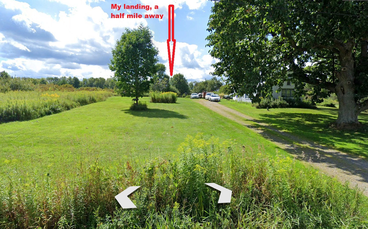
You can see Globe, just north of my landing. Even though it’s the largest town around, it mysteriously didn’t show up on the above Street Atlas map (so I added it). I’ll switch over to Google Earth (GE) where the Orange Dude could get remarkably close to my landing:

He can see my landing location as well as the valley that carries my runoff:

The OD went several miles to the northeast where he found a spot to check out my drainage further downstream:

And here’s what he sees:

I’ll switch over to a streams-only Street Atlas map (with Gilson Wash added by yours truly):

GE let me know that I landed in the watershed of Gilson Wash; on to the San Carlos River (1st hit ever!); on to the Gila River (49th hit); to the Colorado (201st hit).
Look back up at my local landing map. See all of those towns? Every one of them (except Peridot and San Carlos) was founded as a mining town. Mainly silver and copper, mining has thrived since the late 1800s. (San Carlos is the administrative seat of the San Carlos Apache Indian reservation,, and Peridot is also on the reservation.)
I’ll start with a town that was entirely wiped off the face of the earth – Ray. Here’s a back-in-the-day shot of Ray (from the Arizona Memory Project):

Here’s the Ray School:

And Ray in the early 1950s:

From Wiki, here’s a recent shot:

Note that you can see mine workings in the foreground, where Ray should be. When I typed “Ray” in GE, here’s what came up:

Hmmm. Note that Teapot Mountain is the peak shown on the two earlier photos.
Ray was a company town built by Arizona Hercules Copper company in 1909. Through the 1940s, the mining was underground, but then the operation changed to open pit. And poor old Ray was in the way. All of the Ray residents (and a couple of other small towns) were moved to Kearny, built from scratch in the 1950s. Here’s a GE look at Kearny:

Here are a couple of quick-hitters:
From WorldPopulationReview.com, this about Cutter:
Cutter is a city located in Gila County Arizona. Cutter has a 2024 population of 0. Cutter is currently declining at a rate of 0% annually and its population has decreased by __ since the most recent census, which recorded a population of 0 in 2020.
Christmas was so nameda because the nearby mine was staked out and claimed on Christmas day, 1902.
From Winkelman’s website:

Globe was so named because a large spherical (globe-like) silver nugget was found nearby.
Kelvin was named after Kelvin Grove, a park and a neighborhood in Glasgow Scotland. Here’s a picture of the Kelvingrove bandstand and ampitheater (from WhatsOnGlasgow.co.uk):

Peridot is named after a semi-precious gemstone (the August birthstone) found nearby. Here are a couple of pictures of the mineral. First, an uncut specimen:

Hayden is on its way to becoming a ghost town, primarily (according to Wiki) because of widespread contamination from the copper smelter around which the town was built. Here’s a GE shot of the town:

The OD stopped by to get a look at the huge spoil pile just outside of town:

Miami & Globe are next to each other and next to huge copper mine workings:

Miami is the hometown of Manuel Mendoza, a World War II recipient of the Medal of Honor. Here’s the citation. It’s really gruesome, but speaks to the reality of warfare:

For conspicuous gallantry and intrepidity at the risk of his life above and beyond the call of duty:
Staff Sergeant Manuel V. Mendoza distinguished himself by acts of gallantry and intrepidity above and beyond the call of duty while serving as a Platoon Sergeant with Company B, 350th Infantry, 88th Infantry Division during combat operations against the German army on Mt. Battaglia, Italy on October 4, 1944.
That afternoon, the enemy launched a violent counterattack preceded by a heavy mortar barrage. Staff Sergeant Mendoza, already wounded in the arm and leg, grabbed a Thompson sub-machine gun and ran to the crest of the hill where he saw approximately 200 enemy troops charging up the slopes employing flame-throwers, machine pistols, rifles, and hand grenades.
Staff Sergeant Mendoza immediately began to engage the enemy, firing five clips and killing ten enemy soldiers. After exhausting his ammunition, he picked up a carbine and emptied its magazine at the enemy. By this time, an enemy soldier with a flame-thrower had almost reached the crest, but was quickly eliminated as Staff Sergeant Mendoza drew his pistol and fired.
Seeing that the enemy force continued to advance, Staff Sergeant Mendoza jumped into a machine gun emplacement that had just been abandoned and opened fire. Unable to engage the entire enemy force from his location, he picked up the machinegun and moved forward, firing from his hip and spraying a withering hail of bullets into the oncoming enemy, causing them to break into confusion.
He then set the machine gun on the ground and continued to fire until the gun jammed. Without hesitating, Staff Sergeant Mendoza began throwing hand grenades at the enemy, causing them to flee.
Staff Sergeant Mendoza’s gallant stand resulted in thirty German soldiers killed and the successful defense of the hill. His extraordinary heroism and selflessness above and beyond the call of duty are in keeping with the highest traditions of military service and reflect great credit upon himself, his unit and the United States Army.
Phew.
From Wiki, about Superior:
Like nearby Globe, Ray, and Clifton, Arizona, Superior was once part of a huge Apache reservation, but after silver and copper deposits were discovered, those areas were withdrawn from the reservation and returned to the public domain.
[Sounds familiar.]
In 1872, at the height of the American Indian Wars, a band of raiding Apache horsemen were ambushed by a United States Cavalry force from Picket Post Mountain. After losing 50 men, the Apache retreated up the mountain later named “Apache Leap”. According to local legend, the remaining Apache accepted defeat and leapt to their death rather than being captured by the cavalry, thus giving the mountain its name.
Here’s a GE shot of Superior and vicinity:

And a Wiki shot of Apache Leap:

A couple of mining companies are attempting to develop a huge underground copper mine east and south of Superior, known as the “Resolution Copper” project. Over a billion dollars have been spent by the mining companies, but the project faces huge hurdles, especially considering that the land above the mine is known as “Oak Flat,” a large federally-protected area considered sacred to the Apaches.
I’ll close with some Oak Flat pictures posted on GE. First this one, by Galen Beck:

And then three by Art Brown, beginning with this eerily-human-looking rock:

And these lovely Oak Flat shots:


That’ll do it –
KS
Greg
© 2024 A Landing A Day