A Landing a Day

A geography blog where random is king . . .

Archive for May, 2023

Pierceton, South Whitley and Bippus, Indiana

Posted by graywacke on May 26, 2023

First timer? In this formerly once-a-day blog (and now pretty much a once-a-week blog) I use an app that provides a random latitude and longitude that puts me somewhere in the continental United States (the lower 48).  I call this “landing.”

I keep track of the watersheds I land in, as well as the town or towns I land near.  I do some internet research to hopefully find something of interest about my landing location. 

To find out more about A Landing A Day (like who “Dan” is) please see “About Landing” above.  To check out some relatively recent changes in how I do things, check out “About Landing (Revisited).”

Landing number 2625; A Landing A Day blog post number 1070

Dan:  Today’s lat/long (N41o 3.926’, W85o 37.451) puts me in northeastern Indiana:

Here’s my local landing map:

My streams only map shows that I landed in the watershed of the Eel River:

On to the Wabash (33rd hit), Ohio (162nd hit) and Mississippi (1018th hit).

Over on Google Earth (GE), the Orange Dude found a nearby bridge over the Eel (in South Whitley):

And here’s the river:

The OD found a spot close to my landing:


I landed in my friendly neighborhood corn field:

Before getting to my towns, here’s a little Wiki info on the Eel River:

The Miami Indians called the river Kineepikwameekwa Siipiiwi, meaning “river of the snake fish.”  (Don’t skimp on the pronunciation.  Take a deep breath and sound the whole thing out – although I’m unsure of the double i’s*).  Later French explorers called it the Rivière L’Anguille (Eel River).

* I found a pronunciation guide that said “SEE-pie-a-wee.”

Let’s start out with Pierceton.  Of course, I figured that there was some railroad dude named John (or whoever) Pierce who got the town named after him.  But no.  The town was named after our 14th president, Democrat Franklin Pierce, who served from 1853-1857; serving after Millard Fillmore and preceding Abraham Lincoln. 

Of course, there’s a lot of history that I could present, but it’s pretty dry by my taste.  Sufficeth to say, he had a difficult presidency, and history has not smiled upon him.  He managed to walk the thin line between north & south in the early part of presidency, but ended up supporting pro-slavery measures such as the Kansas-Nebraska Act (which allowed the expansion of slavery to newly-formed western states).  Both northerners and southerners had enough of him, and he was abandoned by the Democratic Party and was not nominated to run in 1858. 

Here’s Wiki’s take on his place in history:

As a result of his support of the South, as well as failing to hold the Union together in time of strife, historians and scholars generally rank Pierce as one of the worst  and least memorable U.S. presidents.

His family life could be termed difficult at best. From Wiki:

Pierce was popular and outgoing, but his family life was difficult.  His wife Jane was shy, devoutly religious, and pro-temperance, encouraging Pierce to abstain from alcohol. [He was quite the drinker.] She was somewhat gaunt, and constantly ill from tuberculosis and psychological ailments. She abhorred politics and especially disliked Washington, DC, creating a tension that would continue throughout Pierce’s political ascent.

They had three sons, all of whom died in childhood. Franklin Jr. died in infancy, while Frank Robert died at the age of four from epidemic typhus. Benjamin died at the age of 11 in a train accident.

About the train wreck:

Pierce began his presidency in mourning. Weeks after his election, on January 6, 1853, the President-elect and his family were traveling from Boston by train when their car derailed and rolled down an embankment. Both Franklin and Jane Pierce survived, but their only remaining son, 11-year-old Benjamin, was crushed to death in the wreckage. Pierce was not able to hide the gruesome sight from his wife.

They both suffered severe depression afterward, which likely affected Pierce’s performance as president.  Jane Pierce wondered if the train accident was divine punishment for her husband’s pursuit and acceptance of high office. She wrote a lengthy letter of apology to “Benny” for her failings as a mother.

Ouch.  No wonder Franklin was a heavy drinker.  He did of cirrhosis of the liver at age 64.

On to South Whitley, the town closest to my landing. Under “Notable People,” Wiki mentions one Will Cuppy, humorist and journalist.  The following undifferentiated excerpts are from Wiki and the Indiana History Blog piece by Jessie Cortesi (great name!) entitled “Do Fish Think, Really?” and Will Cuppy’s other musings”:

William Jacob Cuppy (1884 – 1949) was an American humorist and literary critic, known for his satirical books about nature and historical figures.

Cuppy was born in Auburn, Indiana but spent summers at a farm belonging to his grandmother on the banks of the Eel River near South Whitley, Indiana. He later said that this was where he acquired his early knowledge of the natural world which he satirized in his writings.

He graduated from the University of Chicago and served stateside during WW I, and then moved to New York City to pursue a writing career.  In 1926, Cuppy began writing a weekly “Mystery and Adventure” column for the New York Herald Tribune, a platform for his reviews of crime and detective fiction works.  He continued writing the column until his death 23 years later, reviewing a career total of more than 4,000 titles

In 1921, Cuppy moved into a tarpaper and tin shack on Jones’ Island in New York. Suffering from hypersensitivity to sound, Cuppy wished to escape the noise of the city. He lived on the island year-round for eight years, with occasional visits to the city for supplies. The men of the Coast Guard station a few hundred feet down the beach befriended him and shared food, as well as fixed his typewriter. Cuppy called his beach home Tottering-on-the-Brink, giving insight into his mental health. But despite his seclusion, Cuppy’s career progressed.

Cuppy published a book about his experience living on Jones’ Island in 1929, How to Be a Hermit (Or A Bachelor Keeps House). The book was a best-seller—reprinted six times in six months—and put Cuppy on the map as a humorist and author. In traditional Cuppy fashion, he quipped “I hear there’s a movement among architects to use my bungalow as a textbook example of what’s wrong with their business.”  And then there was this telling jest:

Coffee! With the first nip of the godlike brew I decide not to jump off the roof until things get worse—I’ll give them another week or so.

[I’m reading this book; more about it in a bit.]

Then, in 1929, Cuppy had to leave his shack because New York designated the area to become a state park, although he received permission to visit his hermitage for irregular vacations. Cuppy moved to an apartment in Greenwich Village, but even after he left his residence at Jones’ Island he would sometimes be referred to—and refer to himself—as a hermit because he continued to maintain an isolated lifestyle.

Predictably, Cuppy found it difficult to stand the noise of the humming city. He tended to sleep during the day and work during the night to minimize his exposure to the cacophonous sounds. When it all got to be too much, Cuppy would blow on noisemaker as hard as he could out an open window.

From his Greenwich Village apartment, Cuppy continued to turn out magazine articles and books.

Writing funny but factual magazine articles was Cuppy’s real talent. He enjoyed a brief success in 1933 with a humorous talk show on NBC radio with actress and gourmet cook Jeanne Owen.  Basically shy, Cuppy was happiest when he was rummaging through scholarly journals prizing out facts to copy out on his note cards. One of Cuppy’s favorite places was the Bronx Zoo, “where he felt really relaxed.”

Many of Cuppy’s articles for The New Yorker and other magazines were later collected as books: How to Tell Your Friends from the Apes (1931); and How to Become Extinct (1941).

Cuppy’s best-known work, a satire on history called The Decline and Fall of Practically Everybody was unfinished at his death, but was completed by his friend and editor, Fred Feldkamp.  The book’s appeal can be gauged by the fact that CBS broadcaster Edward R. Murrow and his colleague Don Hollenbeck took turns reading from it on the air “until the announcer cracked up.”

The Decline and Fall was completed and published in 1950 by Feldkamp, who sifted through nearly 15,000 of Cuppy’s carefully filed note cards to get the book into print within a year of his friend’s death.

Cuppy’s style was characterized by a satirical take on nature and historical figures. Footnotes were his comedic specialty.  Here’s a sample from Decline and Fall:

Cuppy’s last years were marked by poor physical health and increasing depression. In 1949, facing eviction from his apartment, he took an overdose of sleeping pills and died ten days later.

Like I said earlier, I’m reading “How to be a Hermit.”  Here’s one of many memorable quotes:

Five million housewives (or is it ten?) are asking every morning, as regular as clockwork, “What shall we have for breakfast?”  Of course, I don’t really believe it any more than you do, but that’s what I saw in an ad. 

All history goes to prove that many of these ladies would be asking other things at the time:  do we look like slaves?  Is this Russia?  what did we ever see in you, anyway?  and why don’t you get up and get your own breakfast, you great big lazy loafer? 

Some housewives would not be speaking to the family at al, and others wouldn’t be home yet. 

It seems a little strange to a certain bachelor that the husbands of all these housewives have not done something to answer or otherwise silence this eternal query.  If I were married to housewife who asked me each dewy morn, as I was trying to get another wink of sleep, “What shall we have for breakfast?”  I would simply reply “What have you got?” or “Anything you want, dear!” 

If she kept it up I would add, “Look in the pantry, darling and act accordingly, and you may be sure that whatever you bring me on my tray will be perfectly okay with me, and would you mind slipping me the morning paper, Angel-face?” 

A technique for stubborn cases may easily be improvised by a quick study of the Cro-Magnons and Henry VIII.

And now for a quick stop in Bippus.  Wiki tells us that it’s the hometown of Chris Shenkel (1923 – 2005):

Over the course of five decades he called play-by-play for numerous sports on television and radio, becoming known for his smooth delivery and baritone voice.

I remember him well from my untold hundreds (thousands?) of hours of TV sports viewing back in the day.  While doing a little research, I discovered that he did the play-by-play for a huge 1969 college football game:  #1 Texas (9-0)  vs. #2  Arkansas (also 9-0).  Check out what Wiki said in the “Legacy” section of their entry about the game:

 This game has been nicknamed “Dixie’s Last Stand”, since it was the last major American sporting event played between two all-white teams. However, major college football was not completely integrated until 1972 when the final holdouts, LSU and Ole Miss, fielded their first black varsity members.

Wow.  Amazing that this was the situation not all that long ago . . .

I’ll close with this shot of the Eel River posted on GE by Mike Fromholt just 2 miles NW of my landing:

That’ll do it . . .

KS

Greg

© 2023 A Landing A Day

Posted in Uncategorized | Tagged: , , , , | Leave a Comment »

Flasher, North Dakota

Posted by graywacke on May 19, 2023

First timer? In this formerly once-a-day blog (and now pretty much a once-a-week blog) I use an app that provides a random latitude and longitude that puts me somewhere in the continental United States (the lower 48).  I call this “landing.”

I keep track of the watersheds I land in, as well as the town or towns I land near.  I do some internet research to hopefully find something of interest about my landing location. 

To find out more about A Landing A Day (like who “Dan” is) please see “About Landing” above.  To check out some relatively recent changes in how I do things, check out “About Landing (Revisited).”

Landing number 2624; A Landing A Day blog post number 1069

Dan:  Today’s lat/long (N46o 25.396’, W101o 4.739) puts me in south central North Dakota:

Here’s my local landing map:

My streams-only map shows that I landed in the watershed of Dogtooth Ck; on to the Cannonball River (8th hit); on to the Missouri (461st hit); to the MM (1017th hit):

I looked at Google Earth, and found some more-local (unnamed) watersheds:

The Orange Dude could get a look at the Cannonball just downstream from where the Dogtooth discharges:

And here’s what he sees:

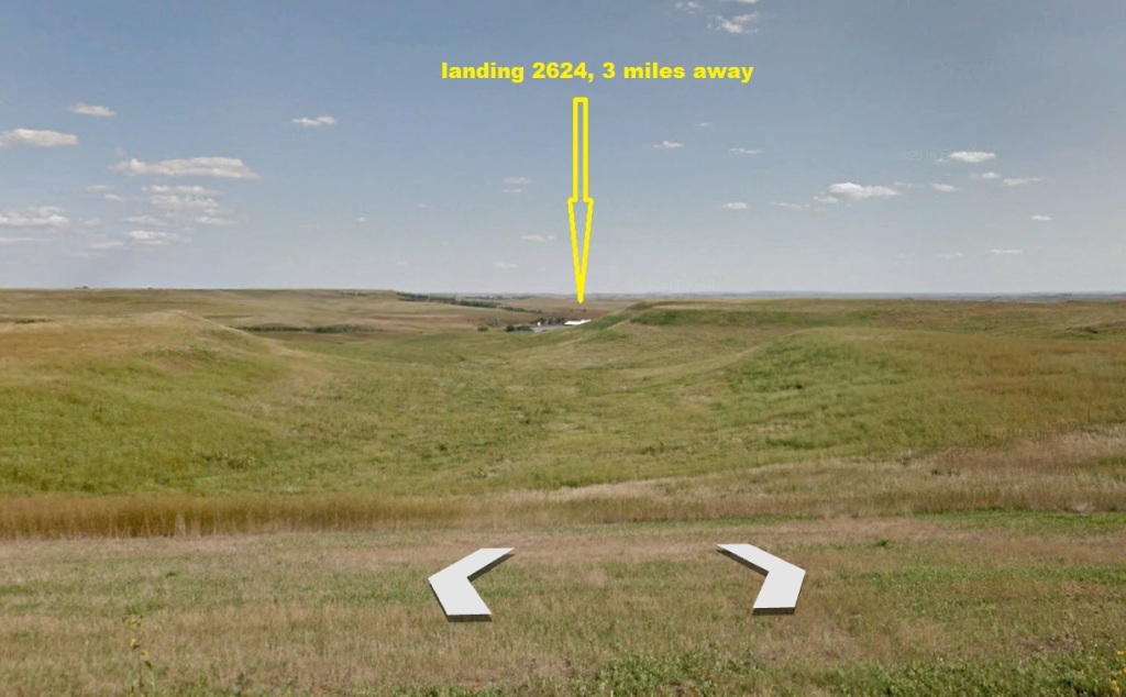
The OD couldn’t get very close to my landing, but he found a high spot where he kind-of-sort-of could see my landing:

And here’s what he sees:

So – on to Flasher (pop 217).  No, it’s not named after the town perv, but rather after Mabel Flasher, “a relative of a town promoter.”  I didn’t hold out much hope for a hook, but there was one – and only one – entry under “Notable People”  (shouldn’t that have been “Notable Person?”):  Hilaire du Berrier.  Monsieur du Berrier was wiki-clickable, so off I went.

Bear with me as I summarize this dude’s resume. I’m using undifferentiated direct quotes from Wiki and Prairie Public (PBS & NPR) along with my own editing thrown in here and there:

He was born Harold Berrier in 1906, the son of early citizens and founders of the town; he was the first white child born in the town.

He hated the name “Harold,” and went by Ha.

Albert Wind-Did-Blow and his wife were friends of the Berriers, and at Harold’s birth, Mrs. Wind-Did-Blow put a pair of tiny beaded moccasins on him and uttered a prayer that the boy would grow to be a great warrior. Whether it can be attributed to that prayer or not, Hal became quite a handful.

When he was only 11, Hal’s parents sent him to military school to get straightened out. Aviation had captured his imagination, and the only thing he wanted to do was fly. But his mother sent him to art school instead.

He complied and worked as a commercial artist in Chicago for a while, but one day when he was 20, he threw it all away and joined a group of barnstormers. So daring was he that he performed a loop-de-loop before he learned how to land his plane. Soon, he formed “Du Berrier’s Flying Circus” and traveled the country, performing audacious feats high above the ground – walking out on plane wings, jumping from one plane to another and hanging by his toes from a rope ladder.

In the late 1920s, Berrier’s uncle, Charles Burke, became a U.S. representative to a commission in Paris, and Hal went along. When he applied for a resident’s permit, the original form of his last name, du Berrier, was reinstated.

The name Hal, however, had to go. By law, French children had to be named after saints – so they changed his name to Hilaire, which suited him fine. Hal was a fan of Napoleon, and St. Hilaire was one of Napoleon’s generals. 

Du Berrier’s three-months abroad stretched into 16 years and included four wars.

He joined the far-right monarchist Action Française movement (portending a life long far-right political activism).  He moved to Monte Carlo where he managed a nightclub, and after it closed, he worked for a perfume business.

In 1935, du Berrier traveled to Ethiopia to fight for Emperor Haile Selassie as a mercenary pilot. Italy invaded Ethiopia soon afterward. In 1936, du Berrier found himself a prisoner on board an Italian truck entering Addis Abba, Ethiopia. Luckily, newsreel filmmakers were doing some filming, supported by the Italians.  They had trouble with their camera shots, and the victorious Italians had to reenter the capital three times. In the midst of all the commotion, du Berrier escaped and hopped a train to Djibouti.

Hey!  I’ve been to Djibouti!  It’s time for a little detour as I’ll share a few memories of the trip . . .

I was working for Mobil Oil in the early 1990s, and the government of Djibouti was improving some port facilities.  They were excavating for some new foundations, and instead of encountering water (i.e., the water table), they hit oil.  Right next door was a Mobil Oil Terminal, where diesel and gasoline came in by ship and were stored in large tanks prior to being trucked to service stations and other facilities. around Djibouti. 

The Djibouti government wanted Mobil & Shell (who also operated a nearby terminal) to figure out what needed to be done so they could continue working on their port project.  I flew to Paris (lucky me) for a meeting with Mobil Oil Française, the entity responsible for Mobil operations in Djibouti.  (Djibouti was formerly a French colony; French is still spoken there.)

I had a fabulous weekend in Paris – it was June, and the weather was perfect – before my Monday meeting.

I had a moment in Paris that still makes me cringe after all these years.  My boss (whose wife’s family was French) asked if I could procure a map of Provence (a French province where his wife’s family was from).  In my wanderings, I found a store that sold maps.  I went in, and engaged a sales person.  I rolled out my high school French, trying my best to communicate.  We struggled mightily, and he wasn’t clear on what I was looking for.  After several minutes of this, he asked, “Do you speak English?”

I was totally embarrassed that I hadn’t tried English earlier; I don’t know what came over me, but I responded – using a vague accent – “A little.”

We finished our transaction, with me speaking broken English, using the same ill-defined accent.  He likely knew that I was an American, but he was gentlemanly enough to let it go.    As I occasionally (to this day) tell this story, he likely tells the story about this crazy American who came into his store one day . . .

Anyway, we had a meeting at the Mobil Française office on Monday.   I remember it was a lunch meeting, and wine was served in the office conference room.  One of our hosts pointed out that Mobil put aside their usual no-alcohol rule for “affiliates from wine-producing countries.”  I stupidly pointed out that the United States produced some wine, but we couldn’t serve alcohol in U.S. offices.  My hosts immediately jumped all over me; pointing out how inferior American wine was to French wine.  While they were going on and on, the Shell representative (a Dutchman who was sitting next to me) leaned over and said “drop it.”

Anyway, after the meeting, several of us hopped on an Air France jet bound for Marseille, where we switched to a flight to Djibouti.  We arrived in the wee hours – I’d say 2:00 am or so.  We went to the only upscale western hotel in town – the Djibouti Sheraton. 

Our French hosts handled the check-in duties (and only French was spoken).  I got my key and headed off to my room; anxious to get some rest since we had a meeting first thing that morning.  I opened the door, and was appalled to see that the room was under construction:  no bed, not even finished dry wall.

I went back to the lobby, but it was entirely empty.  I wandered around looking for anyone, and stumbled on a maintenance or security guy (I think).  Of course, he didn’t speak English.  In my high school French, I said:

“Ma chambre; ce n’est pas bonne.”

Literal translation:  “My room, it is not good.”

I’m not sure if the gentleman actually understood me, but he found someone who got me into a functional room.  Here’s a picture of the Sheraton Djibouti today. Wow. It looks way nicer than I remember – I think there’s been a little landscaping since I was there 30 years ago:

OK.  Back to Monsieur Du Berrier . . .

He somehow made his way from Djibouti back to Europe.  There, (of course), he took interest in the Spanish civil war, and wanted to fly war planes on behalf of Francisco Franco.  However, while on a train, he ran straight into trouble. Gen. Franco was getting help from the Italians, who had put escaped prisoner, Hilaire du Berrier, on their bad-guy list.

Undaunted, du Berrier signed a 1-month contract to spy for Franco. Flying secret missions, he made notes on the various aircraft being supplied to the leftists by the Soviet Union.  Again he was caught, and this time he was to be shot. But when his name was called, officers decided it was a bad idea to shoot an American, and he was allowed to escape on the overnight train.

He made his to London, where he caught the attention of British intelligence, which assessed that he was a “mercenary adventurer”. Afterward, according to du Berrier, he traveled in Central Europe and the Balkans, representing a Dutch aircraft company, and then moved to Shanghai, China.

He tried to sell aircraft in Shanghai but, according to his correspondence, the business flopped.  After Japan’s invasion of China in 1937, du Berrier volunteered for China’s small air force, but his service was ended either with a crash or, as he wrote to his sister, with charges that he was spying for Japan.

Du Berrier was captured in November 1942 by the Japanese and held in the Haiphong Road camp with other foreigners.  He wrote that he was tortured in 1943 by the Japanese.

He made his was to Vietnam after the war, where he was an advisor to the last Vietnamese emperor, Bao Dai as well as Ngo Dinh Diem, who would succeed Bao Dai as Premier.  He wrote a prescient book about Vietnam, published 12 years before the fall of Saigon to the Communist North:

Towards the end of his life, he contributed regular articles to publications associated with the right-wing John Birch Society.

Here’s a review of his Vietnam book, posted on Amazon by Michael Griffith in 2022:

If you really want to understand the Vietnam War, this is a must-read book. If you’re looking for the typical partisan posturing on the Vietnam War, you won’t find it in this book. The author faults both Eisenhower and Kennedy for their Vietnam policies. The book does not deal with the end of the war and how and why the North Vietnamese won, since it was published in 1963, twelve years before the Communist victory. However, the book provides an invaluable look at the reasons for France’s defeat in Vietnam and at the fateful events that led to Diem’s rise to power as the American-installed leader of South Vietnam.

Here’s a flyer for a public Iowa lecture on our hero (probably 1950s vintage):

There you have it.  Not the life expected of a boy born in Flasher, North Dakota in 1906 . . .

The picture posted on GE that’s the closest to my landing is a full 10 miles to the southeast (posted by Dean Rott):

That’ll do it . . .

KS

Greg

© 2023 A Landing A Day

Posted in Uncategorized | Tagged: , , | 2 Comments »

Empire and Venice, Louisiana

Posted by graywacke on May 12, 2023

First timer? In this formerly once-a-day blog (and now pretty much a once-a-week blog) I use an app that provides a random latitude and longitude that puts me somewhere in the continental United States (the lower 48).  I call this “landing.”

I keep track of the watersheds I land in, as well as the town or towns I land near.  I do some internet research to hopefully find something of interest about my landing location. 

To find out more about A Landing A Day (like who “Dan” is) please see “About Landing” above.  To check out some relatively recent changes in how I do things, check out “About Landing (Revisited).”

Landing number 2623; A Landing A Day blog post number 1068

Dan:  Today’s lat/long (N29o 20.503’, W89o 39.273) puts me in far southeastern Louisiana:

My very local landing map shows no roads or towns . . .

Here’s a Google Earth (GE) shot showing the same area:

More water than land, eh?  I can only assume that this is an example of Louisiana’s disappearing saltwater marsh.

Zooming back reveals my proximity to the lower Mississippi River:

And the corresponding GE shot:

And here’s further downstream:

And the regional perspective:

No watershed analysis required!

I found this picture posted on GE showing what I assume is at least a somewhat-healthy marsh:

The Orange Dude was searching for a good spot to get a look at my landing.  He found a bridge near Empire:

Zooming in on the bridge:

And taking a look at the bridge from ground level:

The view towards my landing from the top of the bridge:

While the OD was up on the bridge, he looked the other way and saw lots ‘o fishing boats (more about the fishing industry in a bit):

Someone from the Google Cam universe decided to procure some footage out on the river.  Here’s a map, where the blue lines are where the Google Cam ventured.  Note that all roadways end at Venice:

It turns out that some of the footage was obtained by a Google Rowboat Cam, and some by a Google Motorboat Cam.  Check out this view from the Rowboat Cam:

A two man (oops, two person) rowboat!

There were actually two rowboats out and about; here’s a shot of the second rowboat (which I assume is very similar to the one with the camera):

The footage obtained further downstream (mostly in the side channels) was from this motorboat:

The gentleman’s hat says “U.S. Fish & Wildlife Service.”

The boat ventured forth from a dock in Venice:

Just as the boat was backing out, here’s the view:

A little research reveals that in fact the building belongs to the US Fish & Wildlife Service . . .

I spent some time checking out the various views from the water (both the rowboat the motorboat routes), looking for something interesting, like a close-up of a big ship.  But alas, I found nothing.  So, here’s a shot of big water from the rowboat (with the second rowboat in the distance):

The Mighty Mississippi, indeed!

Back to Empire and Venice, from CommercialFishing.org:

Empire and Venice, Louisiana are two coastal communities on the outer reaches of Plaquemines Parish. Sitting over 70 miles from New Orleans, Venice is known as “the end of the world” for being the last community along the southern reaches of the Mississippi River to be accessible by road.

This unique location provides fishermen with access to a variety of aquatic life located in its bays, bayous, and marshes connected to the Mississippi River and leading into the Gulf of Mexico.

Together, Empire and Venice represent the third largest port for seafood by weight in the United States, yielding millions of pounds of fish and shellfish every year. Fish species commonly caught by fishermen in the area include blackfin tuna, yellowfin tuna, king mackerel, Spanish mackerel, red snapper, dolphinfish, and many more. Shellfish to be harvested in the area include crabs, crawfish, shrimp, and oysters.

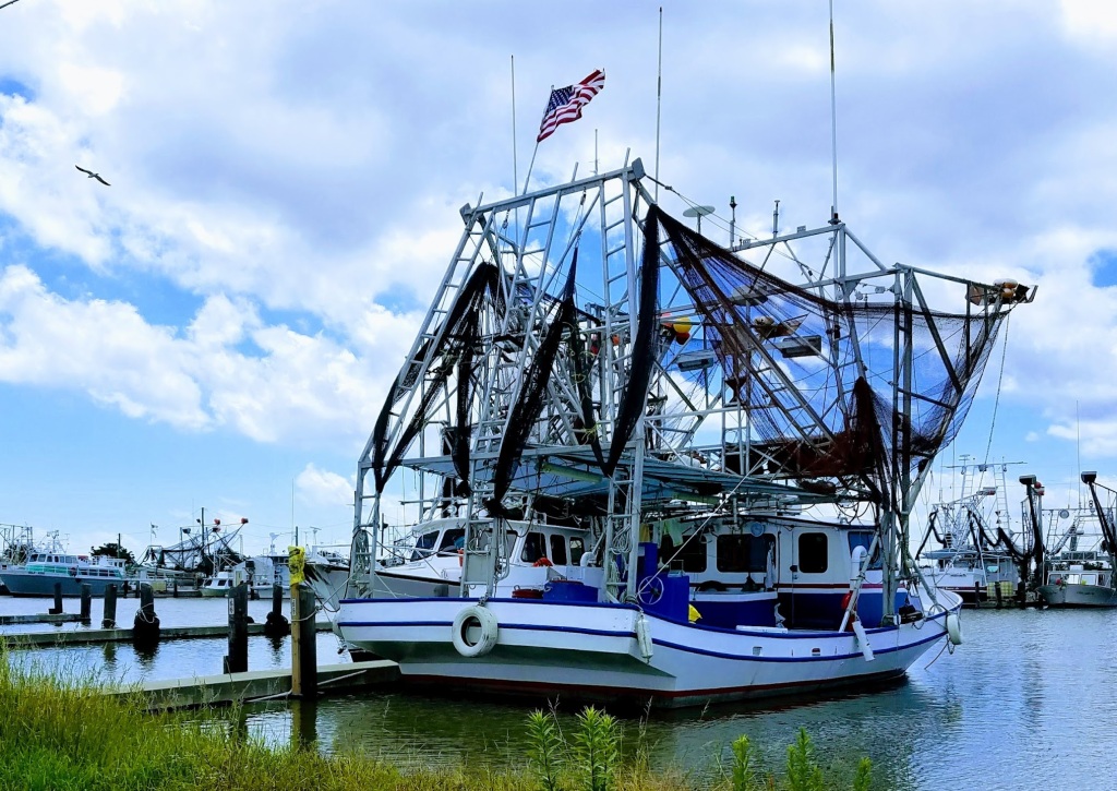
I found this shot of a fishing boat in Empire posted on GE by Loretta Smith Stock:

And this, of three heavy-duty fishing boats (also from Empire) posted by Peter White:

I decided to Google the names of the various boats to see if I could find anything interesting. While checking out “Sea Falcon,” I found this (from OceansArt.us):

OMG! And this:

OMG2.  These huge (150′) boats are right at the base of the OD’s bridge! Think Hurricane Katrina packed a punch?  The storm surge had to be somewhere around 20 feet. Here’s a shot of the Sea Falcon in happier days:

After the boats were removed, the damaged roadway had to be repaired.  Here’s a GE shot from January 2021 showing the spot the boats came to rest, where asphalt was used to repair the concrete highway:

I took this opportunity to check out the evolution of the lower Mississippi Delta. Here’s a cool (very short) time lapse video by Joey Blake showing the evolution of the delta.

Through the years, the river seemed to have a mind of its own – jumping its banks and carving out a new route to the Gulf (and then depositing a new area of river delta).  Well, no more.  The extensive levee system, built for the most part in the middle of the last century, has put the river in a straight jacket, giving it no choice but to maintain its present course for the foreseeable future. 

I’ll close, not with an image posted on GE, but rather with this Getty Image by Mark Ralston, taken near Venice:

Seems like a friendly conversation (but probably not) . . .

That’ll do it . . .

KS

Greg

© 2023 A Landing A Day

Posted in Uncategorized | Tagged: , , | Leave a Comment »

Bude, Mississippi

Posted by graywacke on May 5, 2023

First timer? In this formerly once-a-day blog (and now pretty much a once-a-week blog) I use an app that provides a random latitude and longitude that puts me somewhere in the continental United States (the lower 48).  I call this “landing.”

I keep track of the watersheds I land in, as well as the town or towns I land near.  I do some internet research to hopefully find something of interest about my landing location. 

To find out more about A Landing A Day (like who “Dan” is) please see “About Landing” above.  To check out some relatively recent changes in how I do things, check out “About Landing (Revisited).”

Landing number 2622; A Landing A Day blog post number 1067

Dan:  Today’s lat/long (N31o 20.367’, W90o 48.088) puts me in southwestern Mississippi:

If this landing spot looks familiar, it’s because I landed just 20 miles SW of here a short while back (my Liberty MS, Will Campbell post).

My local landing map:

My streams-only map (with a little help from Google Earth) shows that I landed in the watershed of Candy Creek; on to Cotton Creek; on to a new river, the W. Fork. of the Amite (my 1278th river):

Cotton candy, anyone? Zooming back:

The W. Fork joins up with the E. Fork to form the Amite proper (3rd hit); on south to Lake Pontchartrain (6th hit, just north of New Orleans).

The Orange Dude found a bridge over the West Fork, just downstream from where Cotton Creek joins up:

He headed north a ways to get pretty close to my landing:

He hates it when the landing is way back in the woods:

Enough of preliminaries!  Let’s get on to Bude.  Wiki lets us know that Bude (pop 1,100), was named after the hometown of the wife of one of the town’s founders.  Strangely, Wiki was silent about the whereabouts of this original Bude. 

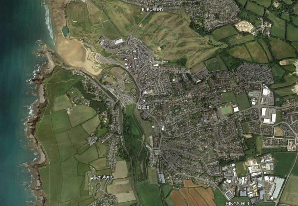
But it didn’t take me much time to figure out that Bude is a town on the Cornwell coast of England:

It was originally known as Bede Haven, bede being a word for a holy man or monk. Here’s a closer Google Earth (GE) view:

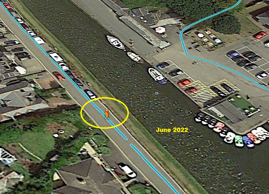
And an even closer look at the waterfront:

I would’ve guessed that this June 2022 shot was at low tide, but I’d be wrong.  Using the GE time machine, I found this April 2021 shot of truly low tide:

OK.  You guessed it.  I found a high tide shot as well (July 2021):

Wow.  Amazing tidal difference, eh?  Well, here’s a Bude tide chart:

On this day, the max tide swing was about 19.5 feet.  Wow.  There are some cool features in and around the Bude waterfront, so we’ll take a little tour, starting with the Bude Canal.  From Wiki:

The coastal area at Bude has sand unusually rich in minerals, and the poor agricultural land in the general vicinity was found to benefit considerably from application of the sand. In the pre-industrial age, actually transporting the sand was difficult, even to land relatively close to the coast.

In 1819, an Act of Parliament was obtained for design and construction of a canal.  After some difficulties in the construction phase, the canal was completed, and opened in July 1823.

So right off, they had to figure out how to keep water in the canal at low tide.  Here’s what they came up with:

The OD (who was delighted to take a trip to Cornwall) got this look at the lock:

The Google-Cam-Mobile guy walked out on the lock and looked upstream:

And downstream:

This is one of only two manually-operated locks in the UK.  Obviously, it only opens at the times of highest tide.  There isn’t much call to open the lock; boats going from the canal to open water (or vice versa) isn’t a daily occurrence. From an article entitled “Sea Lock Movements Update” from the Cornwall Council webpage:.

Saturday 30th April (2022) saw the first successful lock out of the season [there were some unsuccessful attempts?] with local boat “Chug Chug” and yachts “Tina Maria” and “Mistral” leaving the Bude Canal destined for Plymouth and Mylor harbours respectively.

The 4th July saw our second lock movement locking in visiting yacht “Judo” a traditional Cornish Shrimper, and locking out local fishing boat “Mantis”. After a short stay, “Judo” locked out again on the following Wednesday returning to Padstow.

These, sadly due to our exceptionally hot summer and drought conditions, were the only lock operations of the year.

I like the use of the terms “lock in” and “lock out.”

The OD headed up the canal a little and found three ocean-going boats, their owners deciding when to venture out to the open sea.

It appears that the same three boats were there in June of the same year, and apparently summered in Bude:

Anyway, here’s a GE shot of the lock at high tide:

Incidentally, the above picture was in July (of 2021).  It’s hard to tell, but I believe that all of the items on the beach are associated with beach-goers on holiday.  I mean, compare the above with this shot from May, when it’s not exactly beaching-going weather:

This Getty Image confirms that there are plenty of beach goers on a nice summer day:

Summerleaze beach, Bude, Cornwall, UK during the summer holidays. (Photo by: Nik Taylor/Education Images/Universal Images Group via Getty Images)

I noticed that there’s a GE label “Sir Thomas’s Pit.”

Zooming in:

I found a flickr page posted by Jacqueline Ross about the pit.  Here’s her picture:

Under the picture is this write-up:

Sir Thomas’s Pit (now unused), is a rock pool constructed in 1859 by Sir Thomas Acland as a bathing place for men only. Bathers paid the custodian tuppence a swim and were fined a penny if caught swimming naked.

There once was a young man from Bude
Who fancied a dip in the nude
For a thruppenny bit
He could swim in Tom’s Pit
Which included the fine for being rude!

I can’t help myself.  Here’s my version of the limerick:

There once was a young man from Bude
Gen’rally known for his crude-ness
He could swim in Tom’s Pit
Just a thruppenny bit
That included the fine for his nude-ness.

The pit is a tide pool – it gets washed over at high tide, but holds water when the tide goes out. Speaking of artificial tide pools, there’s this, the Bude Sea Pool (at high tide):

And here it is, ready for swimmers at low tide:

From VisitEngland.com:

Take the whole family to this part man-made, part natural sea pool which nestles under the cliffs at Summerleaze beach in Bude.

Built with the aim to provide a safe and fun swimming haven on the Cornish coast, Bude Sea Pool is topped up twice a day by the waves of the Atlantic Ocean creating a unique environment for locals and visitors alike. 

The pool has become a popular tourist attraction for the town, offering a unique experience for families from across the country to enjoy. Let your little ones get their toes wet, watch the sporty ones take a plunge or simply soak up the sunshine beside the fresh salty water.

Since 2011 it has been in the hands of ‘Friends of Bude Sea Pool’; a volunteer charity organisation committed to raising enough money to preserve, improve and enhance the sea pool to carry on benefiting the community and its visitors.

Open throughout the year, Bude Sea Pool is free for all visitors.

Here’s a Trip Advisor shot of the pool:

Hmm.  I wonder what the July-August ocean water temperature is at Bude.  Let me check  . . .

Ouch.  The average August water temperature is 62.6o, aka makes-your-feet-ache cold and hell-no-I’m-not swimming cold!  Maybe on a hot day (at low tide), the Bude Sea Pool might go up a few degrees before getting refilled with frigid ocean water.

FYI, 70o water is damn cold but marginally manageable.  75o is more like it.

What the heck. Here’s a Bude tourist video:

Of course, there are plenty of photos posted on GE to get a look at.  Here’s on by Rob Portlock with a bunch of boats patiently waiting (or not) for high tide:

And this harbour shot by Berto Baizan:

Here’s a shot just south of the beach by Krzysztof Kaczala:

And here’s one by a much-more-pronounceable David Owen:

And another by KK, which shows the structure at “Compass Point” (note the compass directions on the building).  Spoiler alert:  the building was moved, and it no longer accurately lines up with the compass. 

And this, by Christian Pagenkopf:

Before heading back Mississippi, I need to head down the Cornwall coast about 20 miles to the town of Port Isaac. Here’s a lovely shot of the harbour:

Jody and I are big fans of the TV show Doc Martin, starring Martin Clunes as the eccentric doctor for the fictional town of Portwenn, Cornwall.  The show is filmed in Port Isaac, so in a real way, Portwenn is Port Isaac and vice versa.   We feel like we really know the town.  Here’s good ol’ Doc Martin:

Well, I did in fact head back to Mississippi, looking for an appropriate picture posted on GE.  After looking at dozens of churches, various commercial establishments, and truly uninspiring landscape shots, I finally settled on this shot posted by Paul Jr, showing Paul (or Paul’s companion), fishing on Okhissa Lake (just 5 mi NW of my landing):

That’ll do it . . .

KS

Greg

© 2023 A Landing A Day

Posted in Uncategorized | Tagged: , , , , , | Leave a Comment »