I keep track of the watersheds I land in, as well as the town or towns I land near. I do some internet research to hopefully find something of interest about my landing location.
To find out more about A Landing A Day (like who “Dan” is) please see “About Landing” above. To check out some relatively recent changes in how I do things, check out “About Landing (Revisited).”
Landing number 2587; A Landing A Day blog post number 1032
Dan: Today’s lat/long (N33o 18.068’, W95o 8.159) puts me in northeast Texas:
Here’s my local landing map:
And my streams-only map:
As you can see, I landed in the watershed of the White Oak Creek; on to the Sulphur River (5th hit, making the Sulphur the 183rd river on my list of rivers with 5 or more hits); on to the Red River of the South (73rd hit); on, of course, to the Atchafalaya (81st hit).
The Orange Dude found a place to get a look at my landing less than a mile away:
Fortunately, he found a gap in the trees:
He headed northeast, and found a road that crosses White Oak Creek:
And here ‘tis:
It turns out that I featured Talco in an August 2015 post. I rather enjoyed what I wrote, so here ‘tis again:
Moving right along to Talco. Check out this, from the Texas State Historical Association:
In 1910 postal officials asked that the name of the office be changed [from Goolesboro], since other offices in Texas had similar names [like Gouldsboro]. The new name, Talco, was taken from the initials appearing on the wrapper of a candy bar marketed by the Texas, Arkansas, and Louisiana Candy Company.
How about that! A town in Texas named after a candy company! Perusing the internet to find some more information about the candy company, the only references that I could find were related to the naming of Talco, Texas.
Ever suspicious of such circular internet searches, I Googled the company name but without the word “Candy,” which makes sense, since “Talco” doesn’t include a place-holder for the C in candy.. From the Texas State Historical Association, I found this:
The Texas, Arkansas and Louisiana Railway Company was chartered on September 4, 1897, by a group of Cass County businessmen who wanted to connect the Texas and Pacific Railway Company at Atlanta TX with the Kansas City, Pittsburg and Gulf Railroad Company at Bloomburg TX, a distance of eight miles, all within Cass County.
So, Cass County is one county to the east of Titus County, where I landed. My guess is that Talco has nothing to do with candy, and everything to do with luring the railroad. In fact, returning to the “Talco” entry from the Texas State Historical Association (and repeating a sentence quoted above):
The new name, Talco, was taken from the initials appearing on the wrapper of a candy bar marketed by the Texas, Arkansas, and Louisiana Candy Company. As construction on the Paris and Mount Pleasant Railroad began, it became obvious that Talco would be bypassed, so its residents laid out a new townsite closer to the railroad; the new site included a depot.
Wow. The very next sentence after discussing the candy company, the write-up references the problem with a railway bypassing the town. OK, so the names of the railroad companies don’t line up, but I guess that they were trying to lure the Talco Railway to Talco before the Mount Pleasant Railroad actually completed the line.
So the official ALAD position is that the name of the town never had anything to do with candy and has everything to do with the railroad. Talco city fathers (and mothers), what do you think? I know, I know – you’d rather be named after a candy company . . .
Moving on to Wilkinson. I normally wouldn’t feature a town like Wilkinson, but for some reason I found the Texas State Historical Society write-up to be quaintly charming:
Wilkinson is at the junction of Farm roads 71 and 1402, between White Oak Creek and Sulphur Rivers. Until well into the twentieth century the area between White Oak Creek and Sulphur River was known locally as “between the creeks.” It was an isolated, heavily wooded area considered inferior for farming. The roads were poor, and inhabitants generally had few contacts with other parts of the county. The town grew up in the 1870s around the road from Mount Pleasant to Clarksville, one of the few roads in the area. In 1888, when the post office was established, the town was called Wilkinson after a local family.
It probably reached its fullest development in 1896, when it had a reported population of 600, a Baptist church, three stores, a gin, a mill, a wagon maker, and a newspaper, the Free Press, edited by the populist district clerk, J. Ab Ward.
[I could find absolutely nothing about “the populist district clerk, J. Ab Ward.” As you might suspect, the only internet reference to good ol’ J. Ab was this article.]
The census of 1900 did not include Wilkinson in its list of towns with a population of 100 or more; the area was never very heavily populated, and the population estimate of 600 given in 1896 was probably highly exaggerated.
The town declined steadily during the early years of the twentieth century, and the post office was closed in 1914. During the years between World War I and World War II the town came to be known unofficially as Sugar Hill. Many residents believe that the large volume of sugar that was transported into the region to make Prohibition moonshine inspired the nickname. The production of bootleg whiskey became one of the chief occupations of area residents.
During this period the town began to grow again, particularly after oil was discovered in what was dubbed the Sugar Hill oil field in the late 1930s. The Wilkinson School District had an African-American school and an Anglo school in the 1930s. In 1950 the town’s inhabitants voted a bond issue to build a modern brick school. Oil production in the area declined, however, and by 1976 the school had closed.
The Orange Dude had nothing better to do, so he went to Wilkinson to take a look around. He found this, what looks like an abandoned store:
And this, the “modern brick school,” closed in 1976:
Moving on to Midway. From Wiki:
Midway was the birthplace of George McJunkin, who was born a slave.
“Born a slave,” is a peculiar way to identify him. Anyway, George McJunkin was Wiki-clickable:
George McJunkin (1856–1922) was an African American cowboy, amateur archaeologist and historian in New Mexico. He discovered the Folsom site in 1908.
For the rest of the story, I found a National Park Service article about McJunkin. Here are excerpts:
George McJunkin was a former slave from Texas who became a bronco busting cowboy, as well as a bi-lingual ranch foreman (speaking Spanish as well as English). He had an insatiable desire to learn about the world. George gave lessons on how to break a horse in exchange for lessons on how to read. McJunkin began to collect rocks, fossils and crystals, and regularly studied the night sky with his telescope. His intellect and drive to learn led him to make an incredible discovery that changed the world of North American archeology forever. Sadly, the significance of his discovery wasn’t recognized until long after his death.
In August, 1908, a thunderstorm devastated the nearby town of Folsom, New Mexico, dropping 14 inches of rain on the mesa just above the town. After the flood, George went out to survey the damage caused by the torrent. Riding down an arroyo, he noticed some bones protruding from the bank of the arroyo.
There were two things about the bones that were unusual. First, they were protruding from a section of the bank that was 11 feet below the surface, and McJunkin knew that meant they were older than the bones typically found on at or just under the ground surface. Secondly, they were obviously bison bones, but they were much larger than any bison bones he’d seen before.
[Bison antiquus, as the extinct bison was known, was 15-25% larger overall than modern bison. It reached up to 7.5 ft tall, 15 ft long, and weighed 3500 lbs. From tip to tip, the horns of B. antiquus measured about 3 ft. Here’s a figure showing various bison species, including the modern one:
George knew that he’d found something significant and tried to get a professional to look at his discovery. He managed to get two amateur fossil collectors excited after visiting the site, but he couldn’t get anyone’s interest despite sending letters to many different educational institutions.
After McJunkin’s death in 1922, the two fossil collectors kept up the effort to figure out exactly what these bones signified. Four years after his death, the Colorado Museum of Natural History came down and looked at some of the specimens excavated from the site, thinking that at least the Museum would be able to get a reasonably intact specimen of a prehistoric Bison skeleton. Instead, they found something spectacular.
What the Museum found in the embankment are what are now known as “Folsom points”. These are stone projectile points that were clearly used by the bison hunters. What electrified the archeological community was the fact that the points were intermingled with the giant bison ribs, and one of them was actually embedded in one of the ribs.
Since they knew that these giant bison roamed the area back around 9,000 B.C.E., they were now able to place mankind in North America almost 7,000 years earlier than previously thought by leading archeologists of the time. It was a game-changing discovery.
The end result is that an African American former slave was responsible for turning the discipline of Archeology on its ear, and by virtue of his discovery, wrote himself into an indelible spot in American History.
Note: In 1932, an even earlier style of projectile point was found, Clovis, dating back to 11,500 BCE. I’ve blogged about Clovis (of course). Type “Clovis” into the search box to go there.
I’m going to return to my earlier Talco post to finish this off. From that post:
A fairly length perusal of local GE shots pretty much comes up empty. So, instead, I’ll close with this shot [by Kevin Sipe] from the Selah Ranch disc golf course website:
If you’re a disc golf fan, you might want to check out my earlier Talco post. Evidently, Selah Ranch is a nationally-known course.
I keep track of the watersheds I land in, as well as the town or towns I land near. I do some internet research to hopefully find something of interest about my landing location.
To find out more about A Landing A Day (like who “Dan” is) please see “About Landing” above. To check out some relatively recent changes in how I do things, check out “About Landing (Revisited).”
Landing number 2586; A Landing A Day blog post number 1031
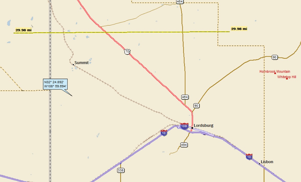
Dan: Today’s lat/long (N32o 24.892’, W108o 59.694) puts me in southwest New Mexico:
Here’s my local landing map:
I need to zoom way in near Lordsburg to find Shakespeare and Valedon (and Eighty-five Hill):
Street Atlas has nothing to say about my watersheds. But, (of course) Google Earth allowed me to tell the story (which ain’t much):
I-10 crosses the Lordsburg Playa, and provides the only place to get a look at my landing (which is about 12 miles away):
The Orange Dude looked off to the north; here’s what he saw:
Notice the sign? Let’s get a better look. (There’s a sign on each side of the west-bound lanes):
Feet Off Brakes? Say what? I actually Googled “feet off brakes,” and found out that this is one sign in a series of signs about what to do in a dust storm. I sent the OD to look for more signs. Here’s the first in the series:
And the second:
The Third:
The fourth is “Feet off Brakes,” and the fifth is:
The website I found about the signs is the Shallow Thoughts blog (by Akkana) with a piece entitled “Dust Storm Burma Shave Signs.” From the post:
Driving on I-10 in New Mexico near the Arizona border, we saw several signs about dust storms. The first one said,
ZERO VISIBILITY IS POSSIBLE [The OD missed this one]
A minute or two later we passed a much more typical New Mexico road sign:
DUST STORMS MAY EXIST [Geez. He missed this one as well.]
New Mexico, the existential state.
But then things got more fun. We drove for a few more miles, then we passed a sign that obviously wasn’t meant to stand alone:
IN A DUST STORM
“It’s a Burma Shave!” we said simultaneously. (I’m not old enough to remember Burma Shave signs in real life, but I’ve heard stories and love the concept.) The next sign came quickly:
PULL OFF ROADWAY
“What on earth are they going to find to rhyme with ‘roadway’?” I wondered. I racked my brains but couldn’t come up with anything. As it turns out, neither could NMDOT. There were three more signs:
TURN VEHICLE OFF
FEET OFF BRAKES
STAY BUCKLED
“Hmph”, I thought. “What an opportunity missed.” But I still couldn’t come up with a rhyme for “roadway”. Since we were on Interstate 10, and there’s not much to do on a long freeway drive, I penned an alternative:
IN A DUST STORM PULL OFF I-10 YOU WILL LIVE TO DRIVE AGAIN
Much better, isn’t it? But one thing bothered me: you’re not really supposed to pull all the way off Interstate 10, just onto the shoulder. How about:
IN A DUST STORM PULL TO SHOULDER YOU WILL LIVE TO GET MUCH OLDER
Oh, well. Even if I’m not old enough to remember real Burma Shave signs, and even if NMDOT doesn’t have the vision to make their own signs rhyme, I can still have fun with the idea.
I remember Burma Shave signs, mainly on family vacations back in the 1950s. For those of you who have no clue, Burma Shave signs were a clever advertising gimmick (for a shaving cream) that consisted of a series of rhyming signs along the road with a usually humorous message (that had nothing to do with shaving cream).
I found this mug with a funny Burma Shave message:
And this:
Back to the dust storm signs on I-10: I’ve always considered myself a bit of a poet, so here’s my Burma Shave poem (that covers all the bases):
IN A DUST STORM FEET OFF THE BRAKE COAST TO THE SHOULDER FOR YOUR SAFETY’S SAKE
SHUT DOWN THE CAR KEEP YOUR SEAT BELT ON ‘TIL THE AIR IS CLEAR AND THEN, YOU’RE GONE!
Moving on to Shakespeare and Valedon. They are both ghostowns; they both were founded in the late 1800s, and both hit a population of about 2,500 in the mid 1920s. They are both mining towns, with gold, silver and copper mines nearby; each had hotels, brothels, schools, theaters, churches, and various stores to serve the miners.
The strange thing is that they’re only one mile apart! Shakespeare was apparently an “independent” mining town while Valedon was strictly a company town associated with the Eight-five Mine. I have no clue about the local politics . . .
Today, each townsite is privately owned, but there’s a big difference. Shakespeare has actual buildings and is open to tourists (although it’s only open every other weekend). Here’s Shakespeare’s homepage:
And a photo from the website:
Valedon on the other hand has only ruins (mostly foundations and such), and the old town site is surrounded by serious fences and No Trespassing signs to keep out the curious.
Staying with Valedon, I found a 1937 book about the geology and mineral deposits of the area by John W. Vanderwill. A few excerpts:
In point of production, history, and character of ore deposits, the Eight-five mine practically constitutes the whole of the Lordsburg district. The Eighty-five mine is on the Emerald vein, and lies beneath Eighty-five Hill. The shops, mine offices, and main entrance to the mine are in Valedon, at the foot of the northeastern slope. The mine workings explored the vein to a depth of 2,250 feet.
Temperatures with the mine increase at an average rate of about 2.6o F per 100 feet of depth.
The book then presented some data that showed that at 1,650′ deep, the temperature in the mine was 97o with 100% humidity.
Wow. Stop and think about what it would have been like to be a miner in 1921. Some miners were fighting for the 8-hr day, but many worked longerr shifts. And the work would have been physically exhausting and dangerous, especially considering 97o with 100% humidity.
After their shift, the miners would love a shower and a beer. The beer, yes. The shower? Maybe not. Remember, we’re out in the desert with water at a premium . . .
Although I couldn’t find anything specifically about the Eighty-five name origin, I did find out that the ore body was discovered in 1885 . . .
Moving on to the big city near my landing, Lordsburg (pop 3,000). From the town website:
Lordsburg made its name as a major automotive and trucking stop along US HIghway 80. US Route 80 was originally known as the Dixie Overland Highway (a coast-to-coast highway from Georgia to California). In 1964, Lordsburg boasted 21 motels, 20 cafes, and 31 service stations— the biggest gas-food-and-lodging stop between Arizona and Texas.
Later, I-10 replaced US 80. While it seemed like it could be a boon for Lordsburg, travelers were eager to get to other destinations and whizzed right by. [And US 80 went right through the heart of town]. As cars got faster, more fuel-efficient, and speed limits increased, Lordsburg began to decline. Lordsburg’s Motel Drive [an actual street name, the former US-80] was listed by the Society of Commercial Archeologists as one of the top ten Most Endangered Roadside Places in the US.
Here’s a map of the Dixie Overland Highway:
From Wiki: The Dixie Overland Highway was an auto trail across the southern United States. It was conceived in 1914 by the Automobile Club of Savannah, as a practical all-year driving route from Georgia to California. It made history as the first ever ocean to ocean highway.
From the town website, here are a couple of shots of downtown Lordsburg in the 1950s:
Wiki mentioned that the Continental Divide Trail (a Mexico to Canada hiking trail that follows the continental divide) travels through Lordsburg. I did a Google search and found out that the divide crosses I-10 east of Lordsburg. The Center for Land Use Interpretation has this to say:
According to the USGS, the Continental Divide crosses I-10 about 33 miles east of Lordsburg. The NM highway department, however, marked the Divide with a road sign two miles further west. But it seems not to really matter, as the roadway has no discernible slope in either direction.
Here’s a picture of the sign:
I bet this sign is baffling to most motorists; I’m sure it gives rise to many a conversation, typically starting off with “Is that sign a joke?”
It’s time to close this down with this photo posted on GE by Len Brehmer, about 10 miles west of my landing:
I keep track of the watersheds I land in, as well as the town or towns I land near. I do some internet research to hopefully find something of interest about my landing location.
To find out more about A Landing A Day (like who “Dan” is) please see “About Landing” above. To check out some relatively recent changes in how I do things, check out “About Landing (Revisited).”
Landing number 2585; A Landing A Day blog post number 1030
Dan: Today’s lat/long (N42o 13.901’, W119o 27.813) puts me in south-central Oregon:
Here’s my very-local landing map:
For scale, it’s about three miles from my landing to Shirk Ranch (labeled in the faint red font). Zooming back (it’s about 25 miles to Plush):
By looking at my very local landing map, you can be pretty sure that I landed in the watershed of Guano Creek, and you’d be right. Here’s my streams-only map:
It flows north to south for about 25 miles, before “discharging” into Guano Lake (actually a dry playa) as shown on this GE shot:
The Orange Dude couldn’t get a look at Guano Creek (but don’t worry, I have pictures), but he could get a long-distance view of my landing:
And here’s what he sees:
Just east of where the OD stopped, the road (Route 140) heads up a dramatic cliff face known as the “Doherty Slide” (the large bluff on the right of the above picture). This stretch of highway is at least regionally known to be one heck of a scary drive – thanks in no small part to the fact that there’s no guard rail. Here’s a YouTube video:
Let’s head over to Plush. Well, it turns out that I featured Plush in a March 2016 post. The post contains an excellent overview of the Basin & Range geologic province. Check it out, if you’ve always wondered about the parallel ridges and valleys that cut across Nevada and parts of neighboring states. About the name Plush, here’s what I said:
Here’s a little tidbit from Wiki about the town Plush:
The name Plush is said to have derived from a mispronunciation of the word flush during a 19th century poker game played in the community.
I don’t buy it. No way someone meant to name it Flush, and they “mispronounced” it as Plush. As I have done in other similar circumstances, I’ve concocted a story about the name origin that’s a little more realistic:
A highly dramatic poker game was set up between two of the original settlers (let’s call them Ben and Andy). The prize for the winner was to be able to name the town. The two gamblers agreed before hand that the name could not have anything to do with the given name of the winner.
So Ben wins, thanks to a flush that won the biggest pot of the game. He announces that the name of the town would thenceforth be “Flush.”
Andy says “Come on, Ben. That sounds like something you do when you clean out the chamber pot. But you know, thinking about “flush” reminds me that my wife mentioned that this little piece of Oregon Territory is pretty damn green compared to most of what you see around here. She actually mentioned that it looked plush. And plush rhymes with flush. Good enough for me. How about Plush?”
Ben couldn’t think of anything better, and it was so agreed.
Back to now: In fact, there’s a fairly substantial creek, Honey Creek, that flows right by Plush before it empties into Hart Lake (which has water all year round). The OD found a bridge over Honey Creek just outside of Plush:
He went maybe a half mile further out of town, and here’s what he saw:
Not very plush, eh? He went back into downtown Plush, and took a look:
See what I mean about the relative plushness of Plush?
Moving on Shirk Ranch. I found an article in the Register-Guard out of Eugene Oregon by William Sullivan about hiking around the Shirk Ranch. William was joined by his partner Janell for the hike. Here are a few excerpts:
Guano Creek may be the most interesting forgotten corner of Oregon’s high desert. When I suggested to Janell that we take a trip there she replied, “Guano? I’m not sure I wanno.” “You’re hilarious, I replied.”
Guano Creek flows only for a month or so each spring with snowmelt. Then the creek attempts to fill Shirk Lake’s alkali flat.
On hearsay, I had given Guano Creek a rare “black star” on the maps for my “Atlas of Oregon Wilderness,” denoting the area as an especially scenic attraction. To my embarrassment, I had never been there. Is there guano in the creek, and if so, are the culprits bats or birds? I didn’t know.
Even after our visit, Guano Creek remains on my short list of contenders for the title “Remotest Place in Oregon.” Halfway between nowhere and nowhere (technically, 25 miles east of the nearest human outpost at Adel), you turn north off Highway 140 onto an unmarked dirt road. Continue about 12 miles straight ahead to a gate with the cutout iron letters “SHIRK RANCH.”
This abandoned ranch is one of the best ghost towns anywhere. The graying buildings have been derelict for 40 years, ever since the government bought out the last of the Shirks. Barn swallows fly through broken windowpanes to build mud nests in what once were bunkhouses, sheds and a grand old ranch house.
The article describes some more of the ranch, and then discusses a hike that they took along Guano Creek. William then goes on to present this dialogue with Janell:
The next day, driving back to Eugene, Janell was upset that I didn’t think I could include Guano Creek in my book of “100 Hikes in Eastern Oregon.” I told her the hike was just too remote, and there wasn’t an actual trail.
“But it was beautiful!” she objected.
I reminded her that she was the one who “didn’t wanno go to Guano.”
“I didn’t see any guano,” she replied. “At least, no more than usual.”
“Then how did it get such a lousy name?”
She thought for a while. Finally, she suggested that the name might come from the slimy algae that grows in the creek bed. By summer, the sun bakes the creek bed rocks black, but as the water dries up, the algae bleaches white.
“It does kind of look like a creek full of bird droppings,” I admitted. “But I’m still not featuring it in the book.”
“Arg,” she said.
From LessTraveledNorthwest.com, are these pictures of Guano Creek:
There’s not much to say about the Shirk ranch. David Shirk bought the land in 1883, and operated a horse ranch there until 1914. The property went through several owners until the Bureau of Land Management bought the place in 1941.
Here’s a cool drone video showing the ranch and the surrounding land. Video by Hodakaguy:
I’ll close with this shot of a barn just outside of Plush, posted on GE by Mike Klein:
JJ’s barn in Plush, OR
I was just interrupted by the Orange Dude who said “Wait a sec! That barn was right next to the bridge over Honey Creek! I’ll head back over there and take another look!” Here’s what he saw:
I keep track of the watersheds I land in, as well as the town or towns I land near. I do some internet research to hopefully find something of interest about my landing location.
To find out more about A Landing A Day (like who “Dan” is) please see “About Landing” above. To check out some relatively recent changes in how I do things, check out “About Landing (Revisited).”
Landing number 2584; A Landing A Day blog post number 1029
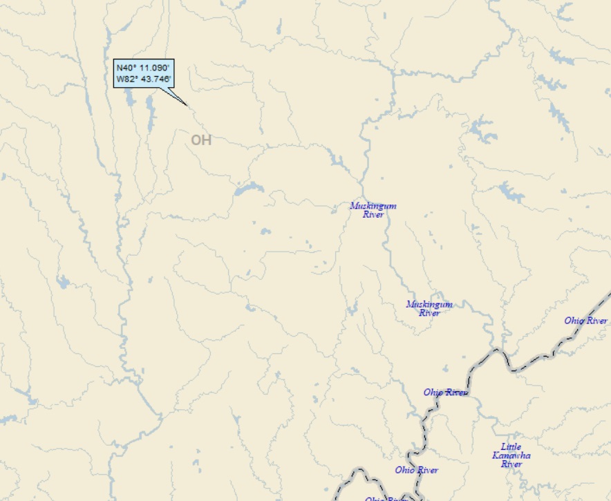
Dan: Today’s lat/long (N40o 11.090’, W82o 43.746) puts me in central Ohio:
Here’s my county-lines-only local landing map:
And here’s the same view, but with the towns:
Before defending my highly unusual choice of an entire county to be titular, we’ll look at my watersheds:
I landed in the watershed of Raccoon Ck; on to the South Fork of the Licking River (1st hit ever!); to the Licking River (1st hit ever!); to the Muskingum River (5th hit, making the Muskingum the 182nd river on my list of rivers with 5 or more hits). Zooming back:
The Muskingum discharges to the Ohio (159th hit); on, of course to the MM (1001st hit).
Let’s head over to Google Earth (GE) and take a look at my landing:
I landed at a golf course! I sent the Orange Dude to get a look at the entrance:
The Clover Valley Golf Club it is. I checked them out on line, and was able to come up with this information about the holes most local to my landing:
It turns out that this is my third golf course landing . . .
The OD moved a short ways west to try to get a look at my landing:
Before getting to the meat of my landing, I must say that I was excited to have landed in the Licking River watershed, for personal reasons. Between the ages of 10 and 17, I lived in Zanesville, located at the confluence of the Licking and Muskingum Rivers. My buddy Paul and I were avid fishermen, angling for carp and catfish out of the Licking River. We used worms (nightcrawlers) and doughballs as bait; we’d cast our lines out in the river, prop our poles on Y-shaped sticks stuck in the sand, and wait for the telltale tugs of the end of our poles.
Our private fishing spot (we never saw anyone else there) was where Joe’s Run hit the Licking River:
I remember often sleeping over at Paul’s and then getting up early to go fishing. The night before, we’d make up dough ball (Paul had a special recipe), then heavily water his front lawn, which would force the nightcrawlers to come up to the surface. Armed with a flashlight, we’d stalk and capture the unsuspecting nightcrawlers. Here’s what Paul’s house and front yard looks like today:
Hmmm. It’s now a “Sun Shack” store, which sells vitamins, herbs and supplements. I’m sure his front yard (and nightcrawler habitat) used to extend all the way out to the sidewalk.
What the heck; while I’m at it, here’s my house:
My dad was a Presbyterian minister and this was (is?) the minister’s house owned by the church. The brick building beyond our house is an apartment building that was built when we lived there. It was under construction in November of 1963. How do I know this? On November 22, I was home sick from school. I was curled up on a window seat, watching the construction next door. Even though the window was closed, a radio was blasting from the cab of a cement truck loud enough for me to hear that Kennedy had been shot.
Moving right along. So why is Licking County titular? Well, I was checking out the Wiki entry for the Licking River where there was an entire section entitled “Johnny Appleseed.” Wiki said that John Chapman (aka Johnny Appleseed) planted his first apple orchard (in 1800 at the age of 26) along the Licking River, on a farm in what is today Licking County.
Various other Johnny Appleseed references also mentioned his early efforts in Licking County. Since I couldn’t name this post after Mr. Chapman, I figured I’d name it after Licking County.
The Johnny Appleseed basics are presented in this Britannica article:
John Chapman was born in Massachusetts in 1774. Little is known about his early life except that his mother died when he was young and that his father fought in the American Revolutionary War. He planted his first apple tree nurseries in the Allegheny Valley in Pennsylvania about 1798 and then began traveling west through Ohio, planting as he went [including Licking County]. Walking for miles every day and sleeping outdoors, he kept well ahead of the pioneers, showing a knack for predicting where they would settle and planting nurseries in those spots.
It is important to note that the apple trees Chapman planted produced mostly cider apples, not the dessert and cooking varieties that most of us are accustomed to seeing in grocery stores. Cider apples are small and unpleasant to eat, but they can be used to produce hard cider, an alcoholic beverage that was a staple of the American diet, especially for pioneers who didn’t always have access to sanitary drinking water.
Within Chapman’s lifetime, oral accounts of his activities began to circulate. Most of these focused on his wilderness skills and his remarkable physical endurance. Chapman was also memorable for his eccentric clothing: instead of a shirt, he usually wore a sack with holes for his head and arms, and on his feet were worn-out shoes or no shoes at all. True to his nickname (which seems to have emerged late in his lifetime), he carried a bag of apple seeds.
I stumbled on an 1892 book by W.H. Milburn entitled “The Lance, Cross and Canoe; the Flatboat, Rifle and Plough in the Valley of the Mississippi.” While that’s a long title, the subtitle is even longer:
“The Backwoods Hunter and Settler, the Flatboatman, the Saddle-Bag Parson, the Stump Orator and Lawyer, as the Pioneers of Its Civilization.”
Towards the end of this 684-page book is a great 10-page section about Johnny Appleseed. Here’s his intro:
I come now to mention a unique and worthy character, one whose name and good deeds are still perpetuated in thousands of fruit orchards scattered throughout the western country. A written sketch of him by W. D. Haley, in Harper’s Magazine, some twenty years ago [Dec 1871], is so complete and satisfactory, that I present it but slightly abridged:
The following are my excerpts of Millburn’s excerpts of Haley’s Harper’s Magazine piece. This piece is waaaaay longer than my usual (and I cut out maybe a third). But if you have a few minutes, just relax and slowly read this enlightening and enjoyable insight to a fascinating character.
The first reliable trace of our modest hero finds him in the Territory of Ohio, in 1801, with a horse load of apple seeds, which he planted in various places on and about the borders of Licking Creek, the first orchard thus started by him being on the farm of Isaac Stadden, in what is now known as Licking County.
During the five succeeding years, although he was undoubtedly following the same strange occupation, we have no authentic account of his movements until we reach a pleasant spring day, in 1806, when a pioneer settler in Jefferson County, Ohio, noticed a peculiar craft with a remarkable occupant and a curious cargo, slowly dropping down with the current of the Ohio River. It was “Johnny Appleseed,’ by which name Jonathan Chapman was afterward known in every log-cabin from the Ohio River to the northern lakes, and westward to the prairies of what are now the States of Indiana and Illinois.
With two canoes lashed together, he was transporting a load of apple seeds to the western frontier for the purpose of creating orchards on the farthest verge of white settlements. With his canoes he passed down the Ohio to Marietta, where he entered the Muskingum, ascending the stream of that river and various tributaries until he reached the region now known as Ashland and Richland counties [about 20 miles north of Licking County].
A long and toilsome voyage it was, as a glance at the map will show, and must have occupied a great deal of time, as the lonely traveler stopped at every inviting spot to plant the seeds and make his infant nurseries. These are the first well authenticated facts in the history of Jonathan Chapman, whose birth, there is good reason for believing, occurred in Massachusetts, in 1775.
He was, at the time of his appearance on Licking Creek, twenty-six years of age, and whether impelled in his eccentricities by some absolute misery of the heart which could only find relief in incessant motion, or governed by a benevolent monomania*, his whole after-life was devoted to the work of planting apple seeds in remote places.
*Monomania = “exaggerated or obsessive enthusiasm for or preoccupation with one thing.”
The seeds he gathered from the cider-presses of western Pennsylvania; but his canoe voyage, in 1806, appears to have been the only occasion upon which he adopted that method of transporting them, as all his subsequent journeys were made on foot.
Having planted his stock of seeds, he would return to Pennsylvania for a fresh supply, which he carried in leather sacks. Securely packed, the seeds were conveyed, sometimes on a horse, and not infrequently on his own shoulders.
In personal appearance, Chapman was a small, wiry man, full of restless activity; he had long, dark hair, a scanty beard that was never shaved, and keen, black eyes that sparkled with peculiar brightness.
His dress was of the oddest description. Generally, even in the coldest weather, he went barefooted, but sometimes, for his long journeys, he would make himself a rude pair of sandals; at other times he would wear any cast-off foot-covering he chanced to find—a boot on one foot and a moccasin on the other.
His dress was generally composed of cast-off clothing that he had taken in payment for apple-trees; and as the pioneers were far less extravagant than their descendants in such matters, the homespun and buck-skin garments that they discarded would not be very elegant or serviceable.
In his later years, however, he seems to have thought that even this kind of second-hand raiment was too luxurious, as his principal garment was made of a coffee-sack, in which he cut holes for his head and arms to pass through, and pronounced it “a very serviceable cloak, and as good clothing as any man need wear,’
In the matter of head-gear his taste was equally unique; his first experiment was with a tin vessel that served to cook his mush; but this was open to the objection that it did not protect his eyes from the sun, so he constructed a hat of paste-board with an immense peak in front and having thus secured an article that combined usefulness with economy, it became his permanent fashion.
Thus strangely clad, he was perpetually wandering through forests and morasses and suddenly appearing in white settlements and Indian villages; but there must have been some rare force of gentle goodness telling in his looks and breathing in his words, for it is the testimony of all who saw him, that notwithstanding his ridiculous attire, he was always treated with the greatest respect by the rudest frontiersman, and what is a better test, the young boys of the settlements forbore to jeer at him.
With grown-up people and boys he was usually reticent. but manifested great affection for little girls, always having pieces of ribbon and gay calico for his small favorites. Many a grandmother today in Ohio and Indiana can remember the presents she received as a child from poor, homeless Johnny Appleseed.
The Indians also treated Johnny with the greatest respect. By these wild and sanguinary [blood thirsty] savages he was regarded as a “great medicine man” on account of his strange appearance, eccentric actions, and especially the fortitude with which he could endure pain.
During the war of 1812, when the frontier settlers were tortured and slaughtered by the Indians, Johnny Appleseed continued his wanderings, and was never harmed by the hostile bands of roving Indians. On many occasions, the impunity with which he ranged the country enabled him to give the settlers warning of approaching danger in time to allow them to take refuge in their fortifications before the Indians could attack them.
His diet was as meager as his clothing. He believed it to be a sin to kill any creature for food, and thought that all that was necessary for human sustenance was produced by the soil.
In this instance, the peculiar religious ideas of Johnny Appleseed were exemplified. He was a most earnest example of the faith taught by Emanuel Swedenborg*, and himself claimed to have frequent conversations with angels and spirits; two of the latter, of the feminine gender, he asserted, had revealed to him that they were to be his wives in a future state, if he abstained from a matrimonial alliance on earth.
*More about Emanuel Swedenborg and the Swedenborgian religion in a bit.
He entertained a profound reverence for the revelations of the Swedish seer, and always carried a few old volumes with him. These he was very anxious should be read by everyone, and he was probably not only the first colporteur* in the wilderness of Ohio, but as he had no tract society to furnish him supplies, he certainly devised an original method of multiplying one book into a number.
*colporteur = a peddler of books, newspapers, and similar literature; often someone employed by a religious society to distribute bibles and other religious tracts.
He divided his books into several pieces, leaving a portion at a log-cabin, and on a subsequent visit furnishing another fragment, and continuing this process as diligently as though the work had been published in serial numbers. By this plan he was enabled to furnish reading for several people at the same time, and out of one book; but it must have been a difficult undertaking for some nearly illiterate backwoodsman to endeavor to comprehend Swedenborg by a backward course of reading, when his first installment happened to be the last fraction of the volume.
Johnny’s faith in Swedenborg’s works was so reverential as almost to be superstitious. He was once asked if, in traveling barefooted through forests abounding with venomous reptiles, he was not afraid of being bitten. With his peculiar smile, he drew his book from his bosom and said, ‘This book is an infallible protection against all danger here and hereafter.’
Whenever he visited a hospitable log cabin, he would pull out one of his books to read out loud. A lady who knew him in his later years, writes in the following terms of one of these domiciliary readings of poor, self-sacrificing Johnny Appleseed:
“We can hear him read now, just as he did that summer day when we were busy quilting up-stairs, and he lay near the door, his voice rising denunciatory and thrilling-strong and loud as the roar of wind and waves, then soft and soothing as the balmy airs that quivered the morning-glory leaves about his gray beard. . His was a strange eloquence at times, and he was undoubtedly a man of genius.”
What a scene is presented to our imagination! The interior of a primitive cabin and an attentive group of listeners, composed of the sturdy pioneer, his wife and children, listening with a reverential awe to the “news right fresh from heaven.” Reclining on the floor, clad in rags, but with his gray hairs glorified by the beams of the setting sun that flood through the open door and the unchinked logs of the humble building, this poor wanderer, with the gift of genius and eloquence, believes that God has appointed him a mission in the wilderness to preach the Gospel of love, and plant apple seeds that shall produce orchards for the benefit of men and women and little children whom he has never seen.
If there is a more sublime faith or a more genuine eloquence to be found in richly decorated cathedrals and under brocade vestments, it would be worth a long journey to find it.
Next to his advocacy of his peculiar religious ideas, his enthusiasm for the cultivation of apple trees in what he termed ‘the only proper way’—that is, from the seed—was the absorbing object of his life. Upon this, as upon religion, he was eloquent in his appeals.
He would describe the growing and ripening fruit as such a rare and beautiful gift of the Almighty, with words that became pictures, until his hearers could almost see its manifold forms of beauty present before them. To his eloquence on this subject, as well as to his actual labors in planting nurseries, the country over which he traveled for so many years is largely indebted for its numerous orchards.
Not only is he entitled to the fame of being the earliest colporteur on the frontiers, but in the work of protecting animals from abuse and suffering he preceded, while, in his smaller sphere, he equaled the good Mr. Bergh.* Whenever Johnny saw an animal abused, or heard of it, he would purchase it and give it to some more humane settler, on condition that it should be kindly treated and properly cared for.
*Henry Bergh, who found the Society for the Prevention of Cruelty to Animals in 1862.
It frequently happened that the long journey into the wilderness would cause the new settlers to be encumbered with lame and broken-down horses, that were turned loose to die. In the autumn Johnny would make a diligent search for all such animals, and, gathering them up, he would bargain for their food and shelter until the next spring, when he would lead them away to some good pasture for the summer. If they recovered so as to be capable of working, he would never sell them, but would lend or give them away, stipulating for their good usage.
His conception of the absolute sin of inflicting pain or death upon any creature was not limited to the higher forms of animal life, but everything that had being was to him, in the fact of its life, endowed with so much of the Divine Essence that to wound or destroy it was to inflict an injury upon some atom of Divinity.
The only occasion upon which he destroyed a venomous reptile was a source of long regret, to which he could never refer without manifesting sadness. He had selected a suitable place for planting apple seeds on a small prairie, and in order to prepare the ground he was mowing the long grass, when he was bitten by a rattlesnake.
In describing the event, he sighed heavily, and said, ‘Poor fellow, he only just touched me, when I, in the heat of my ungodly passion, put the point of my scythe in him, and went away. Sometime afterward I went back, and there lay the poor fellow dead.’
Numerous anecdotes bearing upon his respect for every form of life are preserved, and form the staple of pioneer recollections.
On one occasion, a cool, autumnal night, when Johnny, who always camped out in preference to sleeping in a house, had built a fire near which he intended to pass the night, he noticed that the blaze attracted large numbers of mosquitoes, many of whom flew too near his fire and were burned. He immediately brought water and quenched the fire, accounting for his conduct afterward by saying, “God forbid that I should build a fire for my comfort which should be the means of destroying any of His creatures.’
And this unwillingness to inflict pain or death was equally strong when he was the sufferer by it, as the following will show. Johnny had been assisting some settlers to make a road through some woods, and in the course of their work they accidentally destroyed a hornet’s nest. One of the angry insects soon found a lodgment under Johnny’s coffee-sack cloak, but although it stung him repeatedly he removed it with the greatest gentleness. The men who were present laughingly asked him why he did not kill it. To which he gravely replied that, ‘It would not be right to kill the poor thing, for it did not intend to hurt me.’
He was as methodical in matters of business as any merchant. In addition to their picturesqueness, the locations of his nurseries were all fixed with a view to a probable demand for the trees by the time they had attained sufficient growth for transplanting. He would often give them away to those who could not pay for them.
Generally, however, he sold them for old clothing or a supply of corn-meal; but he preferred to receive a note, payable at some indefinite period. When this was accomplished, he seemed to think that the transaction was completed in a business-like way, but if the giver of the note did not attend to the payment, the holder of it never troubled himself about its collection.
His expenses for food and clothing were so very limited that, notwithstanding his freedom from the auri sacra fames*, he was frequently in possession of more money than he cared to keep, and it was quickly disposed of for wintering infirm horses, or given to some poor family whom the ague or the accidents of border life impoverished.
Auri sacra fames is Latin for “greed (or hunger) for gold.”
We must not leave the reader under the impression that this man’s life, so full of hardship and perils, was a gloomy or unhappy one. There is an element of human pride in all martyrdom, which, if it does not soften the pains, stimulates the power of endurance.
Johnny’s life was made serenely happy by the conviction that he was living like the primitive Christians. Nor was he devoid of a keen humor, to which he occasionally gave vent, as the following will show:
Toward the latter part of Johnny’s career in Ohio, an itinerant missionary found his way to the village of Mansfield, and preached to an open-air congregation. The discourse was tediously lengthy, and unnecessarily severe upon the sin of extravagance, which was beginning to manifest itself among the pioneers by an occasional indulgence in the carnal vanities of calico and “store tea.”
The preacher very frequently emphasized his discourse by the inquiry, “Where now is the man who, like the primitive Christians, is traveling to heaven barefooted and clad in coarse raiment?”
When this interrogation had been repeated beyond all reasonable endurance, Johnny rose from the log on which he was reclining, and advancing to the speaker, he placed one of his bare feet upon the stump which served for a pulpit, and pointing to his coffee-sack garment, he quietly said, “Here’s your primitive Christian.”
The well-clothed missionary hesitated and stammered, and dismissed his congregation. His pet metaphor was destroyed by Johnny’s personal appearance, which was far more primitive than he cared to copy.
Here’s your primitive Christian
In 1838—thirty-seven years after his appearance on Licking Creek—Johnny noticed that civilization, wealth, and population were pressing into the wilderness of Ohio. Hitherto he had easily kept just in advance of the wave of settlement; but now towns and churches were making their appearance, and even at intervals, the stage-driver’s horn broke the silence of the grand old forests, and he felt that his work was done in the region in which he had labored so long.
He visited every house, and took a solemn farewell of all the families. The little girls who had been delighted with his gifts of fragments of calico and ribbons, had become sober matrons, and the boys who had wondered at his ability to bear the pain caused by running needles into his flesh, were heads of families. With parting words of warning of the evils of the encroaching civilization, he left them and turned his steps steadily toward the setting sun.
During the succeeding nine years he pursued his eccentric avocation on the western border of Ohio and Indiana. In the summer of 1847, when his labors had literally borne fruit over a hundred thousand square miles of territory, at the close of a warm day, after traveling twenty miles, he entered the house of a settler in Allen county, Indiana, and was, as usual, warmly welcomed. He declined to eat with the family, but accepted some bread and milk, which he partook of, sitting on the doorstep and gazing on the setting sun.
Later in the evening, he delivered his ‘news right fresh from heaven,’ by reading the Beatitudes. Declining other accommodation, he slept, as usual, on the floor, and in the early morning he was found with his features all aglow with a supernal light, and his body near death.
A physician, who was hastily summoned, pronounced him dying, but added that he had never seen a man in so placid a state at the approach of death. At seventy-two years of age, forty-six of which had been devoted to his self-imposed mission, he ripened into death as naturally and beautifully as the seeds of his own planting had grown into fiber, and bud, and blossom, and the matured fruit.
Thus died one of the memorable men of pioneer times, who never inflicted pain or knew an enemy—a man of strange habits, in whom there dwelt a comprehensive love that reached with one hand downward to the lowest forms of life, and with the other upward to the very throne of God.
A laboring, self-denying benefactor of his race, homeless, solitary, and ragged, he trod the thorny earth with bare and bleeding feet, intent only upon making the wilderness fruitful. His deeds will live in the fragrance of the apple-blossoms he loved so well; and the story of his life, however crudely narrated, will be a perpetual proof that true heroism, pure benevolence, noble virtues, and deeds that deserve immortality, may be found under meanest apparel, and far from gilded halls and towering spires.
I’ll finish this post with a few words about Emanuel Swedenborg and the Swedenborgian religion. I might have never heard of it if, back in the early 80s, I hadn’t done some environmental work in the Philadelphia suburb of Bryn Athyn.
Peculiarly, Wiki states that Bryn Athyn (pop 1,300) “was formed for religious reasons on February 8, 1916.” Reading on, one surmises that the “religious reasons” had to do with forming a Swedenborgian community.
Bryn Athyn is the home of the Bryn Athyn Cathedral, which is the seat of the General Church of the New Jerusalem, a denomination of Swedenborgianism.
Emanuel Swedenborg is described in Wiki as a “Christian theologian, scientist, philosopher and mystic.” As you can guess, he was a complex and fascinating individual. If you’re interested in learning more about the man and the religion which so captivated Johnny Appleseed, a quick visit to Google will do the trick.
I’ll close with this shot of honest-to-God free range chickens, posted on GE by the Copia Farm – run by Caitlin and Dan – located right next to the golf club!
From their website:
Aw. She’s hugging a chicken. Caitlin and Dan could (should?) be disciples of Johnny Appleseed and deserve some free advertisement!