First timer? In this formerly once-a-day blog (and now pretty much a once-every-three-or-four days blog), I have my computer select a random latitude and longitude that puts me somewhere in the continental United States (the lower 48). I call this “landing.” I keep track of the watersheds I land in, as well as the town I land near. I do some internet research to hopefully find something of interest about my landing location. To find out more about A Landing A Day (like who “Dan” is) please see “About Landing” above. To check out some recent changes in how I do things, check out “About Landing (Revisited).”
Landing number 2246; A Landing A Day blog post number 674.
Dan: This is actually getting a little strange. After years of having Texas as my far-and-away number one USer (undersubscribed state), I’ve been on a Texas tear since changing my random lat/long selection methodology. That’s right. Today’s landing is the 30th since the change, and this is my sixth landing in Texas! Texas is now, of course, my far-and-away number one OSer (oversubscribed state)!
Based on the area of Texas (vs. the area of the lower 48), I should have landed in Texas two times out of 30 landings – i.e., I should land in Texas about one in every 15 landings. All I can say is that the Landing God works in mysterious ways . . .
Check out the “About Landing (Revisited)” tab above for some background on what I’m talking about .. .
Here’s my regional landing map:

And my local landing map:

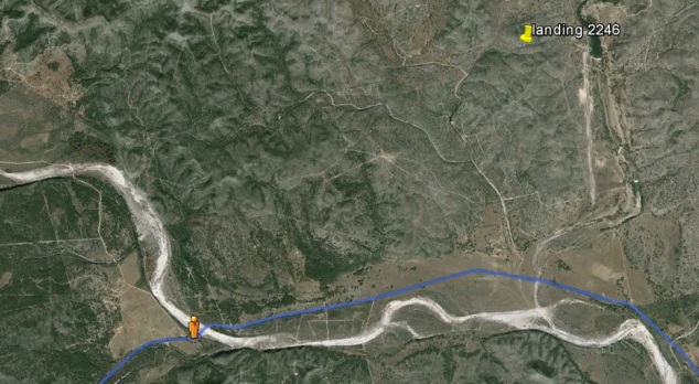
Here’s my local watershed map:

As you can see, I landed in the watershed of the West Nueces R (2nd hit); on to the Nueces (13th hit). Zooming back a little, you can see that the Nueces makes its way to the G of M. I labeled the Frio R as well, just because it’s also local to my landing:

It’s time for my Google Earth (GE) spaceflight in to S-Cen Texas. Click HERE, enjoy the trip, and then hit the back button.
Did you see what looks like a runway? Here’s a static look:
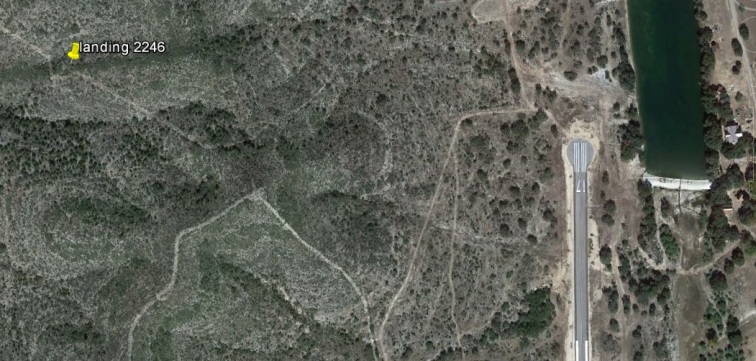
I’ll say! And this is no podunk grass airstrip! It’s paved, and over a mile long. I’m out in the middle of no where, so a paved runway makes no sense. But as you’ll learn soon enough, I figured out the story.
But first, here’s a shot showing Street View coverage near my landing (and you can see the entire runway):

And here’s what the orange dude sees:

And here’s SV coverage of the West Nueces River (which certainly looks dry):
Here ‘tis – and it certainly is dry!

The sign says “West Prong Nueces River.” There’s not even a bridge, so it must be dry almost all of the time. . .
Anyway, as mentioned earlier, I figured out why there’s a paved runway. I noted that there’s a road near the runway, which heads south to the road with Street View coverage I used for my landing shot. I took a look at where the two roads meet:

4 Aces Ranch, eh? A Google search shows that there’s some big money associated with this ranch. It’s a mere 17,132 acres (which amounts to nearly 27 square miles). I’m sure that I landed on 4 Aces Ranch property and that the runway is for the private jet of the incredibly wealthy owner.
Besides a runway, there are several houses, including the main house with a very fancy pool.
The pool installer (Cantera Pools) actually put together a virtual reality tour of the pool and patio:
According to LandsOfAmerica.com, the property was for sale, but has been sold. Anyway, there are a bunch of great photos on their website, which I’ll save for the end of this post.
So I checked out each and every small town looking for a hook. I found a minor hook in Camp Wood, but elsewhere? Nada, nada, nada. So, the winner is Camp Wood. And here’s the story (in my own words, garnered primarily from TexasEscapes.com):
In 1924, a St. Louis automobile dealer (Leon Klink) developed an acute interest in airplanes. For $250, he bought a WWI-surplus Canadian bi-plane (an OX-5 Curtiss).
From FineArtAmerica.com, here’s a shot of an OX-5 Curtiss:

Leon didn’t know how to fly, but he convinced an acquaintance of his (Charles Lindbergh, known as “Slim”) to pilot the plane to warmer southern climes (it was January). Slim took him up on the deal.
The two winged their way to Florida without incident (top speed, 75 mph). Before leaving St. Louis, Slim had applied to the Army’s Flight School in San Antonio TX. While in Florida, Slim got word to report to the School on March 15.
This left the two adventurers plenty of time, so they decided to follow the Southern Pacific Railroad tracks across the southern tier of the U.S., heading for California where Leon wanted to visit some friends.
Without any problem, they made it all the way to S-Cen Texas, still following the Southern Pacific railway.
Slim knew that the railway intercepted the Rio Grande, and that he’d have to bear to the right at that point. I did a little research, and found this map showing what I’m talking about. See the arrow and the note? The red rail lines are labeled “Union Pacific,” which back in the day were Southern Pacific (at least the one in our area of interest).

So what happens? Carefully check out this map (obviously put together by yours truly):

That’s right! He came across the Nueces River and mistook it for the Rio Grande! And this, in spite of the fact that he was a good 50 miles away from the Rio Grande. Here’s a GE close-up shot, more clearly showing Lindbergh’s wrong turn:

So, he’s cruising up the Nueces, blissfully unaware that he’s not following the Rio Grande. But then, when he reached Camp Wood, the railroad ended! Lindbergh knew then that he messed up (plus, he was low on fuel). So, he landed in a pasture north of town.
Now, I’ll quote directly from TexasEscapes.com:
Intending to take off again as soon as they refueled, the two aviators got a ride into town to buy gasoline.
Getting back to their plane late in the day, the two cross-country flyers accepted an invitation from a nearby ranch family to spend the night before resuming their flight. Years later, Ray Chant recalled that they sat around his family’s fireplace enjoying the warmth of the hearth and good conversation, though Klink talked more than Slim.
The next day when they tried to take off, they found the ground too soft for the Canuck to get up sufficient airspeed. Removing their luggage, the passenger seat and tool box, they tried again with only Slim in the plane.
The plan worked. Slim flew toward Camp Wood to find a better landing spot while Klink hitched a ride into town, hauling everything they had taken off the plane. Slim put the Canuck down on the Uvalde road, the town’s gravel main street.
Almost everyone in the county gathered to see the flyers on their way west. But as Slim taxied, confident he could squeeze the plane’s 43-foot wingspan between telephone poles on each side of the street, one of the wheels hit a rut. The aircraft veered sideways, its wing clipping one of the telephone poles. Now out of control, the aircraft crashed into the side of Warren Pruett’s hardware store.
Klink and Slim climbed out of the cockpit uninjured, relieved to find that no one had been inside the store when they hit it. The impact scattered pots and pans, caused a portrait of President Calvin Coolidge to drop to the store’s wooden floor and, according to some, left a horse collar draped around the plane’s smoking radiator.
It turns out that they needed a new propeller, and shellac to repair the plane’s cloth fuselage, which they ordered from Houston. As can be imagined, this all took a while.
After repairs, they managed to take off safely, but on their very next landing, they ran into a stiff bush and the cloth fuselage was damaged once again, creating another week’s delay. By this time, Lindbergh had to report to San Antonio; Klink hopped a train to California to visit his friends while Slim flew to San Antonio. I wonder if Klink got his airplane back? I presume so . . .
There you have it: The story of Lindbergh’s Wrong Turn. History would have been quite different if the rut on their takeoff “runway” had been a little deeper, causing the plane to veer a little more sharply, resulting in a serious crash that took the life of the pilot. I’m sure history is replete with similar near misses . . .
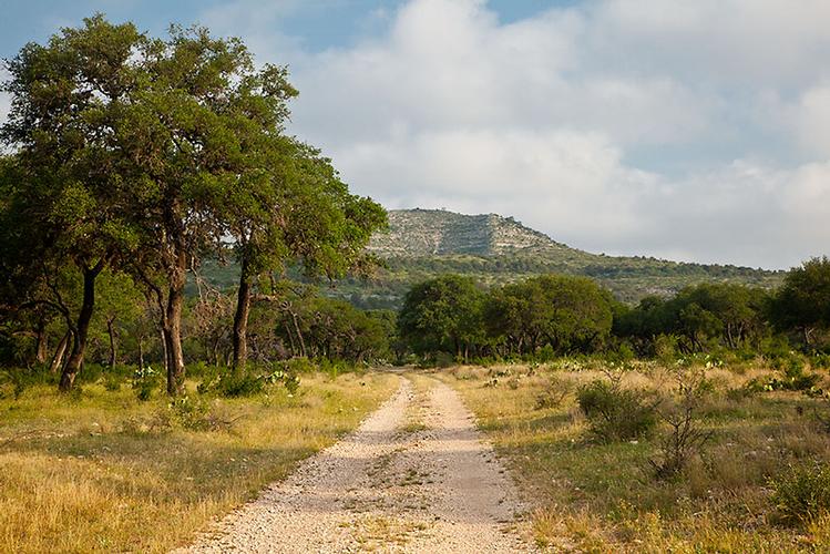
Time to wrap things up. As discussed earlier, I actually landed on the 4 Aces Ranch property, and found a real estate website (LandsOfAmerica.com) that had a bunch of pictures. Since these are all very local to my landing, I’ll close with a few of the most scenic:


That’ll do it . . .
KS
Greg
© 2016 A Landing A Day
