Ajo, Lukeville and Why, Arizona
Posted by graywacke on July 5, 2021
First timer? In this formerly once-a-day blog (and now pretty much a once-a-week blog), I use an app that provides a random latitude and longitude that puts me somewhere in the continental United States (the lower 48). I call this “landing.”
I keep track of the watersheds I land in, as well as the town or towns I land near. I do some internet research to hopefully find something of interest about my landing location.
To find out more about A Landing A Day (like who “Dan” is) please see “About Landing” above. To check out some relatively recent changes in how I do things, check out “About Landing (Revisited).”
Landing number 2530; A Landing A Day blog post number 974

Dan: Today’s lat/long (N32o 9.023’, W112o 54.260) puts me in southeast (south-central?) Arizona:

My local landing map shows that I landed out in the boonies – and about 15 miles north of the border:

Wonder why you don’t see Why? Well, it’s too little to show up on the map. Obviously, we’ll find out soon enough about the how, where and why for Why.
I’ll head over to Google Earth (GE) to get a look at my local drainage situation::

I landed in the watershed of the San Cristobal Wash, on to the Gila “River” (43rd hit). The Gila is about 65 miles from my landing, as the buzzard flies.
Here’s a cool GE shot looking west where the San Cristobal Wash runs through a gap in the mountains just west of my landing:

The Orange Dude hopped on I-8 and was able to get a look at the San Cristobal Wash just before it “discharges” into the Gila “River.” Here’s what he sees:
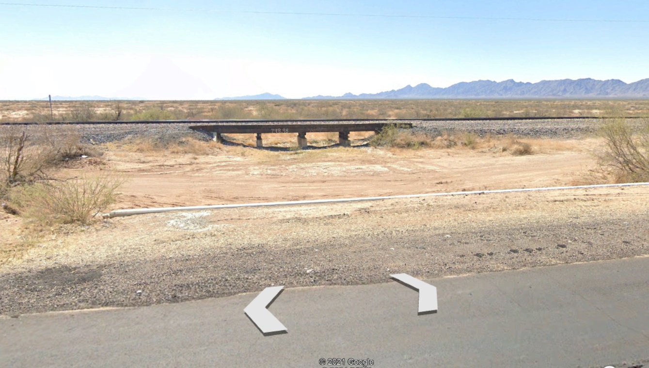
Amazingly, there’s Street View coverage of some dirt roads that run near the mouth of the San Cristobal. The OD situated himself on one of the dirt roads that actually crosses the Gila River bed:

Here’s his view of the crossing:

And here’s what he sees when he looks “upstream:”

I’m not sure how many years have gone by with no water over the road . . .
JFTHOI, I checked out GE where the Gila meets the Colorado. The OD was disappointed that the lack of Street View coverage prevented him from getting in on the action. Here’s the GE shot:
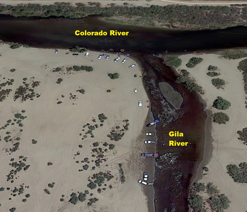
Is that water I see? And are there a bunch of cars parked right along the water’s edge? Here’s a closer look:

It looks like folks gather here to play in the water!
Wiki has this to say about the Gila:
The Gila River and its main tributary, the Salt River, would both be perennial streams carrying large volumes of water, but irrigation and municipal water diversions turn both into usually dry rivers. Below Phoenix to the Colorado River, the Gila is usually either a trickle or completely dry, as is the lower Salt towards its junction with the Gila.
A long time ago [I’m guessing, but maybe a hundred years ago] the Gila River was navigable by large riverboats from its mouth to near Phoenix, and by smaller craft from Phoenix nearly to the Arizona – New Mexico border.
That’s truly amazing, considering what the OD just showed us! Wiki also tells this interesting Gila-related story:
In 1944, 25 German prisoners of war pulled off the largest and most spectacular escape from an American compound, digging a 178-foot tunnel out of the Navy’s Papago Park Prisoner of War Camp (near Phoenix). All of the men were eventually captured, though some remained at large for more than a month.
Among the last to be captured were three German soldiers who had based their audacious but ill-fated escape plans on a stolen highway map of Arizona, which showed the Gila River leading to the Colorado River, which in turn led to Mexico. Devising a scheme to flee by water, the Germans constructed a collapsible kayak under the noses of their American captors, tested it in a makeshift pool within the prison compound, then sneaked it out through the tunnel. Their plan was perfect – except for the map. The Gila, shown as a healthy blue waterway, turned out to be little more than a dry rut.
Oops.
Back to my landing: The OD couldn’t get any closer than about 8 miles from my landing. Here’s a very oblique shot showing where he went to see the big yellow arrow:
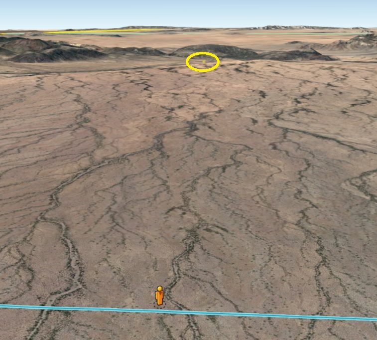
See the small mountain right behind my landing? I used it to accurately situate my landing from the OD’s perspective:

Why do I care about these details? God (Landing God, that is) only knows . . .
Do you see what looks like telephone poles? Here’s a closer view:

Nope! They’re cacti . . .
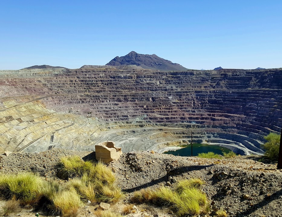
So I’ll hit my towns alphabetically, and start with Ajo. Ajo is a former mining town – copper primarily – and in fact the Phelps Dodge mine there had over 1,000 employees back in 1940s and 1950s.
Here’s a GE shot of Ajo, showing massive scars left by mining:

The open pit mine is just sitting there – here’s a shot posted on GE by Chad Stewart.
You regulars (all 17 of you) know I have a thing with name origins; Wiki has this to say:
Ajo is the Spanish word for garlic. The Spanish may have named the place using the familiar word in place of the similar-sounding Tohono O’odham Indian word for paint: oʼoho. The Tohono O’odham people obtained red paint pigments from the area and may have referred to the area as o’oho.
Next comes Lukeville (pop 35), which isn’t really a town, just a support area around a border crossing. Here’s a GE shot:

And a close-up of the border crossing:

I moved south to take a look at the much-more-developed Mexican side:

Two things are interesting about the above. First, how about the name of the town: “Hombres Blancos!” You don’t need to be a Spanish language scholar to realize that this translates as “White Men.” I did a Google search to try to get the story behind the name, but I couldn’t find anything. Oh, well.
The second point of interest is that there’s a line of cars heading north to the border crossing that stretches from the words “Hombres Blancos” up to the border. I wonder how long a wait that was?
And zooming back, the main Mexican town nearby is Sonoyta (pop 13,000):

Anyway, Wiki tells us that Lukeville was named after World War I pilot Frank Luke, an Arizona native who was awarded a posthumous Medal of Honor.
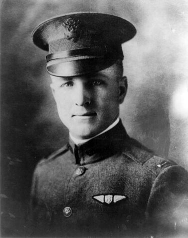
Frank Luke is wiki-clickable:
Between September 12 and September 29, 1918, Luke was credited with shooting down 14 German balloons and four airplanes: Luke achieved these 18 victories during just 10 sorties in eight days, a feat unsurpassed by any pilot in World War I.
About his death:
The evening of September 29, Luke flew to the front to attack three balloons, six miles behind the German lines. Luke shot down the enemy balloons but was then severely wounded by a single machine gun bullet fired from a hilltop a mile east of the last balloon site he had attacked.
Luke landed in a field after strafing a group of German soldiers on the ground near a small stream. Although weakened by his wound, he made his way toward the stream, intending to reach the cover of its adjacent underbrush. He collapsed some 200 meters from his airplane. Approached by German infantry, Luke drew his Colt Model 1911 pistol and fired a few rounds at his attackers before dying.
A personal note: Luke Airforce Base – located outside of Phoenix – was also named after Frank Luke. Back in the mid-80s, I was project manager for a subsurface environmental investigation at the Base. We were looking at several “areas of concern” where base activities may have contaminated subsurface soils and groundwater. I have a couple of stories:
We were installing a “monitoring well,” which extends to below the watertable (more than 100’ below the surface) so that we could sample the groundwater to see if it were contaminated. Anyway, we used a “mud rotary” drilling rig, which has a hollow drill rod. Mud is circulated down the drill rod, out the drill bit, back up the hole outside the rod and into a “mud pit.” There’s a mud pump in the pit that pumps the mud back down the hole.
The mud serves two functions: 1) it carries the sand we were drilling through up to the surface and 2) it keeps the hole open as the well is drilled and well casing is installed. The pit is pretty big – dug by a backhoe – and is designed to allow the sand being carried by the mud to settle out in the bottom of the pit.
All of this to let you know two things: First, while digging the mud pit, the backhoe severed an electric line that carried power to the munitions section of the base. We didn’t realize it at first, until the weapon-bearing MPs descended upon our work site, wondering what the hell we did to cut off the power. Oops.
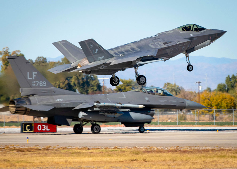
Secondly: Luke AFB was (and still is) a main F-16 and F-35 training facility, so all day long was a very-cool constant show of jets taking off & landing. Here’s a shot from the Luke AFB website showing an F-35 taking off with an F-16 behind it:
At one point, the jet action was extra intense, and I took a step back as I was looking up and checking out the scene. I happened to be standing at the edge of the mud pit, and I fell backwards into the pit. The pit was probably 6’ deep, and I was waist-high in mud. I still remember my coworkers saying things like: “Look at poor Gregory! It looks like he won’t be able to get out without help. Do we have a ladder anywhere? I don’t think so. Does anyone know where to find a ladder? Well, you’ll be fine until we find one, won’t you, Greg?”
Another day, we noticed a dark gray line in the sky along the horizon west of the base. The dark gray line got thicker and thicker, and began to practically loom over us. Someone shouted out “dust storm!” We scrambled to put various instruments and sampling equipment into our van before it hit. When it hit, visibility went to nearly zero, and we were surrounded by a blizzard of stinging dust. We didn’t get the van fully closed up before it hit, so we had a true dusty mess on our hands. . .
Here’s a shot of an oncoming dust storm from the State of Washington website:

One more quickie: One day it became eerily quiet, and re realized that no jets were flying. After several minutes of quiet, a single F-16 took off. As soon as it was airborne, the tail dipped down so that the jet was straight up and down. It seemed to pause for a second. Then up it went like a rocket. Soon, it was just a speck, but then it began to fall seemingly haphazardly back towards earth.
Of course, the pilot was in total control, and he then nose-dived straight back down towards the runway. At the last possible moment, he pulled out of the dive and with a dramatic roar zoomed right over us. He then took the jet through a series of breathtaking maneuvers – passing low over the Base flying upside down, etc.
Needless to say, no work was done during this incredible show. Afterwards, our Air Force contact was checking out our progress, and we asked him what the show was all about. He said that brass were visiting, and the Base decided to have their ace put on a show . . .
It’s time to move on down the alphabet, all the way to Why. Wiki says this about the name:
The town derives its name from the fact that two major highways, State Routes 85 and 86, intersect in a Y-intersection. At the time of its naming, state law required all city names to have at least three letters, so the town’s founders named the town “Why” as opposed to simply calling it “Y.”
Here’s a view of the town (with South up):

See the Y? I highlighted the roads to make it clearer:

And here’s a Street Atlas map:

I’m done with the three towns, but not the fact that I landed in the Organ Pipe Cactus National Monument:

I’ll close with some organ pipe cactus pictures posted on GE. First this, by Tom Ringold:

And then two by Ralph Maughan who – totally unbeknownst to him, I suspect – has contributed many many Google Earth photos to A Landing A Day:


I just took a brief journey through ALAD, checking out just some of Ralph’s great photos. I think I might do a Ralph Maughan post . . . .
That’ll do it . . .
KS
Greg
© 2021 A Landing A Day

Mark Miller said
All 17 of us!
I wonder if the cacti were to be named today they’d be telephone pole cactus and not organ pipe cactus…
Jordan said
Really great stories about your time near Luke Air Force Base! In particular the dust storm, the mud pit fall, and the air show by the ace.