First timer? In this formerly once-a-day blog (and now pretty much a once-a-week blog), I use an app that provides a random latitude and longitude that puts me somewhere in the continental United States (the lower 48). I call this “landing.”
I keep track of the watersheds I land in, as well as the town or towns I land near. I do some internet research to hopefully find something of interest about my landing location.
To find out more about A Landing A Day (like who “Dan” is) please see “About Landing” above. To check out some relatively recent changes in how I do things, check out “About Landing (Revisited).”
Landing number 2482 ; A Landing A Day blog post number 922
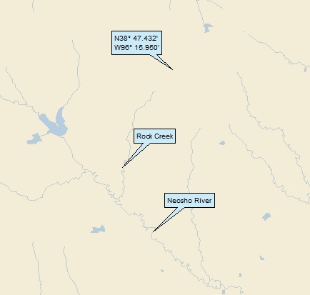
 Dan: Today’s lat/long (N38o 47.432’, W96o 15.950’) puts me in E-Cen Kansas:

If “E-Cen Kansas” sounds familiar, it should. Just two landings ago, I landed a mere 25 miles south of today’s landing. I featured Americus, which is 9 miles south of one of today’s titular towns, Bushong.
Here’s my local landing map:

My streams-only map shows that I landed in the Rock Creek watershed, on to the Neosho River (the same river as two landings ago, 9th hit).
Zooming out:

The Neosho (as I’m sure you all remember) discharges to the Arkansas (136th hit); on to the MM (960th hit).
Of course, per usual I went over to Google Earth (GE) to check things out. I didn’t get a great look at my landing (even though I could get within a half mile) thanks to intervening trees:

Here’s what the OD sees:

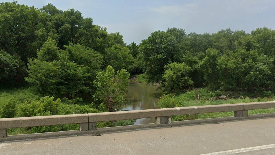
A few miles south, the OD got a good look at Rock Creek, and yes, I’m sure it’s Rock Creek:

Thanks, Kansas DOT! And here’s the creek:
Just northeast of my landing, I noticed a dead-ended GoogleMobile route:

Here’s a close-up:

Here’s a shot of the “road.”

The Orange Dude asked, “where in the heck are you taking me?” I think he was imagining being a character in a Stephen King novel . . .
Here are some more StreetView shots:


I think that the GoogleMobile driver had some second thoughts about driving up this apparent driveway, as well! Anyway, there’s another entryway at the end of the road:

This appears to be quite the cool property!
I think I’ll start with Council Grove, far-and-away the largest local town (pop 2,200). From Wiki:
It was named after an 1825 agreement between White European Americans and the Osage Nation that was signed under “Council Oak,” allowing settlers’ wagon trains to pass westward through the area on the Santa Fe Trail. Pioneers later gathered at a nearby grove of trees so that wagons could band together for their trip west.
I wonder what the Osage Nation received in return for their cooperation? Whatever it was, I’m sure it amounted to nothing in very short order.
Also. There’s a “Madonna of the Trail” statue in Council Grove, which is also Wiki-clickable:
Madonna of the Trail is a series of 12 identical monuments dedicated to the spirit of pioneer women in the United States. The monuments were commissioned by the National Society of Daughters of the American Revolution. They were installed in each of the 12 states along the National Old Trails Road, which extended from Cumberland, Maryland, to Upland, California.
Here’s a map of the road (established in 1912, as one of the original roads created due to that new-fangled contraption, the automobile:

Back to Wiki:
Created by sculptor August Leimbach and funded by contributions, the Madonna of the Trail monuments were intended to provide a symbol of the courage and faith of the women whose strength and love aided so greatly in conquering the wilderness and establishing permanent homes. Dedicated in 1928 and 1929, the twelve statues became sources of local pride. Through the continuing efforts of local and national groups, all are currently in good condition and on display.
Here’s the one in Council Grove:

Time to head on over to Bushong. From Wiki:
 The city, originally a whistle-stop of the Missouri Pacific Railroad, was first named Weeks. The city took its present name in 1886 in honor of St. Louis Browns [baseball] catcher Albert J. “Doc” Bushong.
Following the Browns’ victory in the 1886 World Series over the Chicago White Stockings, the Missouri Pacific Railroad honored several of the St. Louis players by naming some of their depots after the players.
Bushong (whose career spanned 16 years, from 1875 – 1891) had played every game in the series and was at bat in Game Six, when the winning run scored by Curt Welch stealing home. The city of Bushong is the only one still carrying its name from the 1886 World Series.
The 1886 World Series was decided in extra innings of game 6 by Curt Welch’s so-called “$15,000 slide” following a passed ball [while our man Bushong was at the plate]. The decisive run scored by Welch became one of the most famous plays in the history of baseball in that era.
Following his baseball retirement in 1891, Bushong, then 33 years old, began practicing dentistry full-time along with two brothers, who were also dentists, at a large dental house in Hoboken, New Jersey. Eventually he became manager of the establishment. Also while working in Hoboken, he began and, according to baseball historian William Rankin, “built up a large and flourishing practice”, at his home in south Brooklyn, 442 Ninth Street.
I hitched my wagon up to GE to get a look at Doc Bushong’s house at 442 Ninth Street, and here’s what the OD could see:

442 is the building straight ahead, the second from the corner. It looks like there’s a business on the ground floor. Yup. It’s “Brooklyn Net Wellness:”

I don’t get their peculiar sign that appears to highlight “klyn et ess” (on this July 2018 photo). I Googled “klyn et ess” and found one hit – a May 2019 subReddit post (HalfLitSigns) that included a picture of the sign, with this note: “This subreddit is for any light-up signs that have only part of their letters lit up, making it spell something stupid.”
The Street View photo was taken in June 2019; if in fact the sign is simply missing some of its letters due to an electrical issue, it has been that way for almost a year! Here’s hoping they’ve fixed their sign.
BTW, There’s another photo posted on HalfLitSigns subreddit:

FYI, Brooklyn Net Wellness is an upscale massage parlor. It has good reviews, but is shut down thanks to the crazy times we’re all living through.
Today’s last stop is Admire. According to the town website, the locals pronounce it AD-mire. Say AD-mire three times out loud, to fix it in your consciousness. Paraphrasing from the ADmire’s website:
The town was founded in 1886 by a group of investors (including Joseph Admire.) In June 1887, the town fathers decided to run an excursion train to Admire for the purpose of interesting people in moving there and buying lots.
From the website:

The day before the excursion visitors were to arrive, the groves of trees around town were ransacked for nice thrifty trees. [These cut-down trees were evidently “planted” around town.] The visitors could not help admiring the beautiful appearance of the town. In one of the speeches given that day one of the visitors remarked how admirable Admire was. The joke was on the town, however, for in a few days when the trees had withered and dried the town had the appearance of being very, very dead.
A drought then hit, and the town suffered greatly. The website tells a story that a 4’ diameter well was hand dug, trying to obtain more water for the town. The well came up totally dry, however.
Back to the website:
The work was ended when a portion of the well caved in. One man was trapped at the bottom of the well, and rather than risk further loss of life in a rescue operations, as another cave in was feared, the well was filled up. The lone well digger still resides one hundred and sixty feet below Main Street.
Staying with the Admire town website, here’s a shot of the “Community Pride” web page:

Look closely at the gentlemen (lady?) on the left. Are you as baffled as I am about why this picture was chosen? Some guy (or woman) in a cowboy hat with:
- A strap around his (her) hat
- Tape around the toes of his (her) shoes
- Tape around one of his (her) ankles
- A cloth bag with a leash
I’m sure there’s an explanation . . .
I’ll close with a couple of shots of a very cool, very old stone wall, just north of my landing. First this, posted on GE by Maxine Arnoldy:

And then this of the same wall from a different angle, by Al Schmidt:

That’ll do it . . .
KS
Greg
© 2020 A Landing A Day
